Uyar elevation
Uyar (Krasnoyarskiy), Russia elevation is 357 meters and Uyar elevation in feet is 1171 ft above sea level [src 1]. Uyar is a populated place (feature code) with elevation that is 158 meters (518 ft) bigger than average city elevation in Russia.
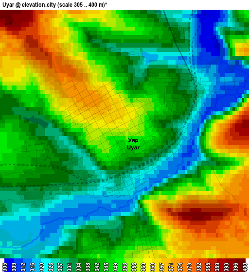
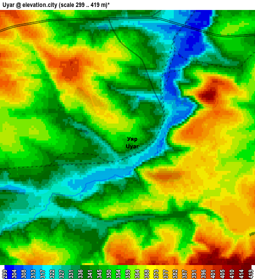
Below is the Elevation map of Uyar, which displays elevation range with different colors. Scale of the first map is from 305 to 400 m (1001 to 1312 ft) with average elevation of 344.9 meters (=1132 ft) [note 1]
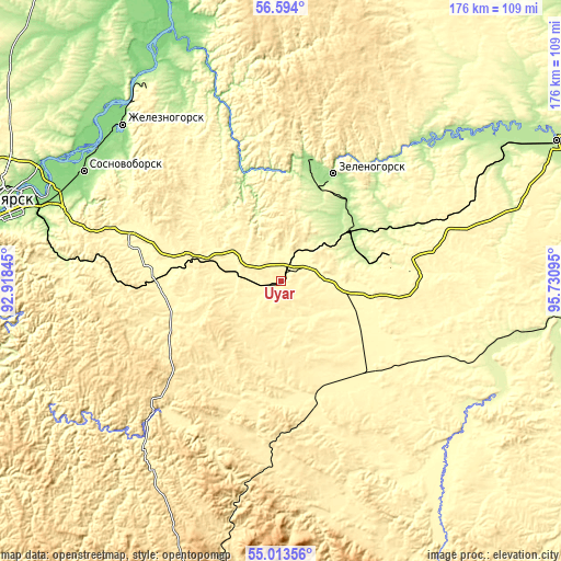
These maps also provides idea of topography and contour of this city, they are displayed at different zoom levels. More info about maps, scale and edge coordinates you can find below images.
| \ | Map #1 | Map #2 | Topo.Map |
| Scale [m] | 305..400 m | 299..419 m | × |
| Scale [ft] | 1001..1312 ft | 981..1375 ft | × |
| Average | 344.9 m = 1132 ft | 354.1 m = 1162 ft | × |
| Width | 5.49 km = 3.4 mi | 10.98 km = 6.8 mi | 175.7 km = 109.2 mi |
| Height | 5.49 km = 3.4 mi | 10.98 km = 6.8 mi | 175.7 km = 109.2 mi |
| ↑Max Latitude | 55.836486° | 55.861156° | 56.594° |
| Latitude at center | 55.8118° | 55.8118° | 55.8118° |
| ↓Min Latitude | 55.787099° | 55.762382° | 55.01356° |
| ← Min Longitude | 94.280755° | 94.236809° | 92.91845° |
| Longitude center | 94.3247° | 94.3247° | 94.3247° |
| →Max Longitude | 94.368645° | 94.412591° | 95.73095° |
Nearby cities:
Cities around Uyar sort by population:
• Zheleznogorsk elevation 149 m
69.4 km,  314°
314°
• Zelenogorsk 167 m
37.5 km,  27°
27°
• Sosnovoborsk 154 m
70.4 km,  299°
299°
• Berëzovka 144 m
79.4 km,  287°
287°
• Borodino 337 m
37.9 km,  73°
73°
• Aginskoye 342 m
71.6 km,  149°
149°
• Zykovo 187 m
74.3 km,  282°
282°
• Irbeyskoye 249 m
73.1 km,  105°
105°
• Shalinskoye 388 m
36.9 km,  253°
253°
• Partizanskoye 390 m
35.2 km,  173°
173°
• Ural 259 m
28.7 km, 68°
• Irsha 276 m
32.3 km, 66°
Multilingual:
 En español:
Uyar elevación 357 m.
 En France:
Uyar élévation 357 m.


Sources and notes:
- [note 1] Map square and city borders are not equal. Map elevation data is calculated only from area inside that square.
- [src 1] Elevation data from geonames database provided with same terms of usage.
- [src 2] The elevation map of Uyar is generated using elevation data from NASA's 3 arcsec (90m) resolution SRTM data.
- [src 3] Base (background) map © OpenStreetMap contributors tiles are generated by Geofabrik and OpenTopoMap.
Copyright & License:
This Uyar Elevation Map is licensed under CC BY-SA. You may reuse any part from this page, if you give a proper credit by linking to this URL:
 More info on terms of use page.