Zavodoukovsk elevation
Zavodoukovsk (Tyumen’ Oblast), Russia elevation is 75 meters and Zavodoukovsk elevation in feet is 246 ft above sea level [src 1]. Zavodoukovsk is a populated place (feature code) with elevation that is 124 meters (407 ft) smaller than average city elevation in Russia.
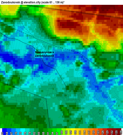
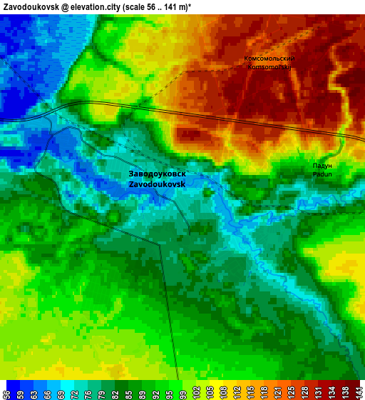
Below is the Elevation map of Zavodoukovsk, which displays elevation range with different colors. Scale of the first map is from 61 to 138 m (200 to 453 ft) with average elevation of 86.8 meters (=285 ft) [note 1]
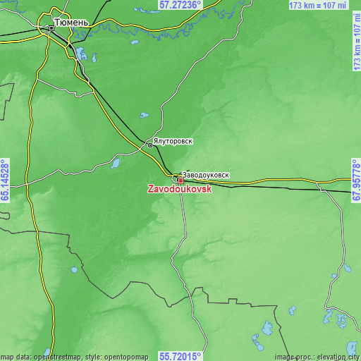
These maps also provides idea of topography and contour of this city, they are displayed at different zoom levels. More info about maps, scale and edge coordinates you can find below images.
| \ | Map #1 | Map #2 | Topo.Map |
| Scale [m] | 61..138 m | 56..141 m | × |
| Scale [ft] | 200..453 ft | 184..463 ft | × |
| Average | 86.8 m = 285 ft | 94.2 m = 309 ft | × |
| Width | 5.39 km = 3.3 mi | 10.79 km = 6.7 mi | 172.6 km = 107.2 mi |
| Height | 5.39 km = 3.3 mi | 10.79 km = 6.7 mi | 172.6 km = 107.2 mi |
| ↑Max Latitude | 56.528445° | 56.552674° | 57.27236° |
| Latitude at center | 56.5042° | 56.5042° | 56.5042° |
| ↓Min Latitude | 56.47994° | 56.455664° | 55.72015° |
| ← Min Longitude | 66.507585° | 66.463639° | 65.14528° |
| Longitude center | 66.55153° | 66.55153° | 66.55153° |
| →Max Longitude | 66.595475° | 66.639421° | 67.95778° |
Nearby cities:
Cities around Zavodoukovsk sort by population:
• Yalutorovsk elevation 64 m
22.6 km,  317°
317°
• Borovskiy 56 m
78.3 km, 319°
• Vinzili 66 m
69.5 km, 316°
• Omutinskiy 99 m
68.8 km,  92°
92°
• Bogandinskiy 67 m
59.1 km, 317°
• Isetskoye 71 m
75.5 km,  268°
268°
• Uporovo 66 m
27.6 km,  218°
218°
• Antipino 67 m
82.6 km, 324°
• Mokrousovo 113 m
78.3 km,  170°
170°
• Yurginskoye 106 m
62.2 km,  55°
55°
• Novaya Zaimka 115 m
23 km,  95°
95°
• Onokhino 62 m
77.5 km,  307°
307°
Multilingual:
 En español:
Zavodoukovsk elevación 75 m.
 En France:
Zavodooukovsk élévation 75 m.
 Auf Deutsch:
Sawodoukowsk höhe über dem Meeresspiegel ist 75 m.

Sources and notes:
- [note 1] Map square and city borders are not equal. Map elevation data is calculated only from area inside that square.
- [src 1] Elevation data from geonames database provided with same terms of usage.
- [src 2] The elevation map of Zavodoukovsk is generated using elevation data from NASA's 3 arcsec (90m) resolution SRTM data.
- [src 3] Base (background) map © OpenStreetMap contributors tiles are generated by Geofabrik and OpenTopoMap.
Copyright & License:
This Zavodoukovsk Elevation Map is licensed under CC BY-SA. You may reuse any part from this page, if you give a proper credit by linking to this URL:
 More info on terms of use page.