Verkhnebakanskiy elevation
Verkhnebakanskiy (Krasnodarskiy), Russia elevation is 276 meters and Verkhnebakanskiy elevation in feet is 906 ft above sea level [src 1]. Verkhnebakanskiy is a section of populated place (feature code) with elevation that is 77 meters (253 ft) bigger than average city elevation in Russia.
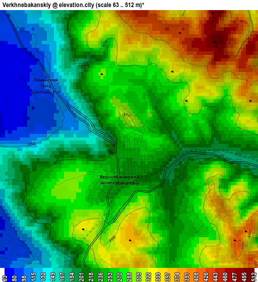
Below is the Elevation map of Verkhnebakanskiy, which displays elevation range with different colors. Scale of the first map is from 63 to 512 m (207 to 1680 ft) with average elevation of 251.8 meters (=826 ft) [note 1]
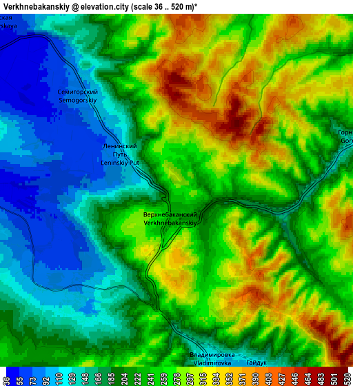
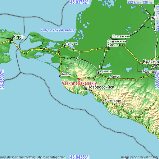
These maps also provides idea of topography and contour of this city, they are displayed at different zoom levels. More info about maps, scale and edge coordinates you can find below images.
| \ | Map #1 | Map #2 | Topo.Map |
| Scale [m] | 63..512 m | 36..520 m | × |
| Scale [ft] | 207..1680 ft | 118..1706 ft | × |
| Average | 251.8 m = 826 ft | 226.1 m = 742 ft | × |
| Width | 6.93 km = 4.3 mi | 13.86 km = 8.6 mi | 221.7 km = 137.8 mi |
| Height | 6.93 km = 4.3 mi | 13.86 km = 8.6 mi | 221.7 km = 137.8 mi |
| ↑Max Latitude | 44.880317° | 44.911448° | 45.83752° |
| Latitude at center | 44.84917° | 44.84917° | 44.84917° |
| ↓Min Latitude | 44.818006° | 44.786825° | 43.84356° |
| ← Min Longitude | 37.613275° | 37.569329° | 36.25097° |
| Longitude center | 37.65722° | 37.65722° | 37.65722° |
| →Max Longitude | 37.701165° | 37.745111° | 39.06347° |
Nearby cities:
Cities around Verkhnebakanskiy sort by population:
• Novorossiysk elevation 9 m
16.4 km,  147°
147°
• Krymsk 22 m
27.8 km,  71°
71°
• Anapa 16 m
26.7 km,  280°
280°
• Anapskaya 16 m
22 km, 283°
• Gostagayevskaya 69 m
22.7 km,  328°
328°
• Rayevskaya 126 m
8.1 km,  259°
259°
• Myskhako 23 m
22.8 km,  157°
157°
• Gayduk 100 m
7.9 km, 154°
• Kiyevskoye 15 m
27.8 km,  40°
40°
• Tsibanobalka 42 m
28.7 km,  300°
300°
• Abrau-Dyurso 136 m
17.2 km,  194°
194°
• Sukko 30 m
19.4 km,  253°
253°
Multilingual:
 En español:
Verkhnebakanskiy elevación 276 m.
 En France:
Verkhnebakanskiy élévation 276 m.
 Auf Deutsch:
Verkhnebakanskiy höhe über dem Meeresspiegel ist 276 m.

Sources and notes:
- [note 1] Map square and city borders are not equal. Map elevation data is calculated only from area inside that square.
- [src 1] Elevation data from geonames database provided with same terms of usage.
- [src 2] The elevation map of Verkhnebakanskiy is generated using elevation data from NASA's 3 arcsec (90m) resolution SRTM data.
- [src 3] Base (background) map © OpenStreetMap contributors tiles are generated by Geofabrik and OpenTopoMap.
Copyright & License:
This Verkhnebakanskiy Elevation Map is licensed under CC BY-SA. You may reuse any part from this page, if you give a proper credit by linking to this URL:
 More info on terms of use page.