Levoberezhnyy elevation
Levoberezhnyy (Moscow Oblast), Russia elevation is 168 meters and Levoberezhnyy elevation in feet is 551 ft above sea level [src 1]. Levoberezhnyy is a section of populated place (feature code) with elevation that is 31 meters (102 ft) smaller than average city elevation in Russia.
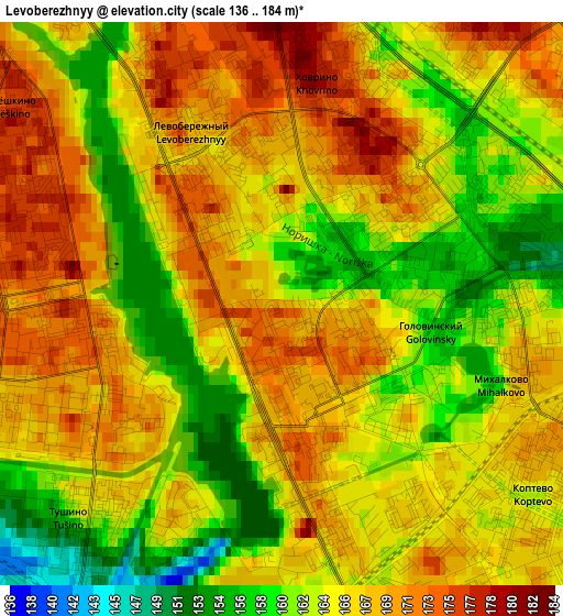
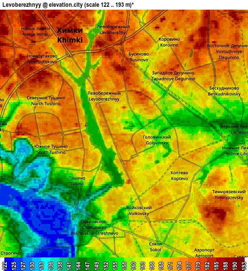
Below is the Elevation map of Levoberezhnyy, which displays elevation range with different colors. Scale of the first map is from 136 to 184 m (446 to 604 ft) with average elevation of 165.5 meters (=543 ft) [note 1]
These maps also provides idea of topography and contour of this city, they are displayed at different zoom levels. More info about maps, scale and edge coordinates you can find below images.
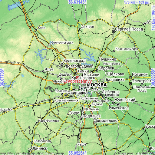
| \ | Map #1 | Map #2 | Topo.Map |
| Scale [m] | 136..184 m | 122..193 m | × |
| Scale [ft] | 446..604 ft | 400..633 ft | × |
| Average | 165.5 m = 543 ft | 164.2 m = 539 ft | × |
| Width | 5.49 km = 3.4 mi | 10.97 km = 6.8 mi | 175.6 km = 109.1 mi |
| Height | 5.49 km = 3.4 mi | 10.97 km = 6.8 mi | 175.5 km = 109.1 mi |
| ↑Max Latitude | 55.874661° | 55.899307° | 56.63143° |
| Latitude at center | 55.85° | 55.85° | 55.85° |
| ↓Min Latitude | 55.825323° | 55.80063° | 55.05254° |
| ← Min Longitude | 37.439385° | 37.395439° | 36.07708° |
| Longitude center | 37.48333° | 37.48333° | 37.48333° |
| →Max Longitude | 37.527275° | 37.571221° | 38.88958° |
Nearby cities:
Cities around Levoberezhnyy sort by population:
• Khimki elevation 185 m
6.2 km,  327°
327°
• Strogino 125 m
5.7 km,  231°
231°
• Shchukino 153 m
5.9 km,  200°
200°
• Vostochnoe Degunino 174 m
5.7 km,  54°
54°
• Sokol 159 m
5.9 km,  159°
159°
• Pokrovskoye-Streshnëvo 157 m
4.9 km, 198°
• Novovladykino 149 m
6.2 km,  90°
90°
• Likhobory 147 m
5.2 km, 90°
• Novokhovrino 171 m
2.1 km,  29°
29°
• Slobodka 156 m
6.5 km,  73°
73°
• Golovinskiy 155 m
0.9 km,  61°
61°
• Koptëvo 166 m
4.3 km,  150°
150°
Multilingual:
 En español:
Levoberezhnyy elevación 168 m.
 En France:
Levoberezhnyy élévation 168 m.
 Auf Deutsch:
Levoberezhnyy höhe über dem Meeresspiegel ist 168 m.
 На русском:
Аксиньино, Левобережный высота над уровнем моря 168 м
Sources and notes:
- [note 1] Map square and city borders are not equal. Map elevation data is calculated only from area inside that square.
- [src 1] Elevation data from geonames database provided with same terms of usage.
- [src 2] The elevation map of Levoberezhnyy is generated using elevation data from NASA's 3 arcsec (90m) resolution SRTM data.
- [src 3] Base (background) map © OpenStreetMap contributors tiles are generated by Geofabrik and OpenTopoMap.
Copyright & License:
This Levoberezhnyy Elevation Map is licensed under CC BY-SA. You may reuse any part from this page, if you give a proper credit by linking to this URL:
 More info on terms of use page.