Argudan elevation
Argudan (Kabardino-Balkariya Republic), Russia elevation is 358 meters and Argudan elevation in feet is 1175 ft above sea level [src 1]. Argudan is a populated place (feature code) with elevation that is 159 meters (522 ft) bigger than average city elevation in Russia.
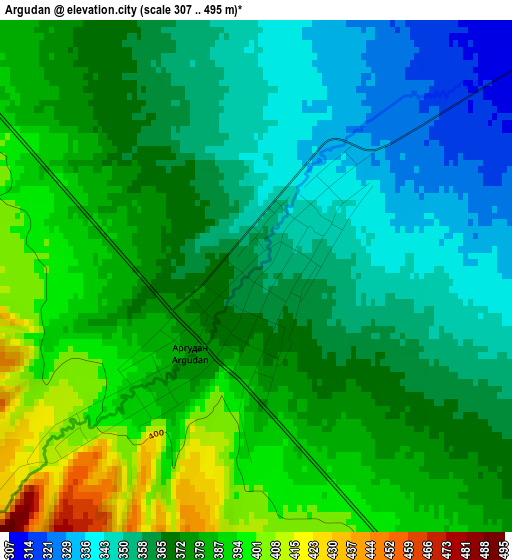
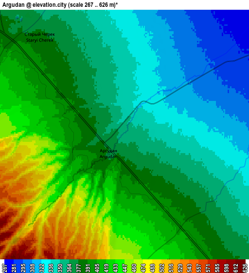
Below is the Elevation map of Argudan, which displays elevation range with different colors. Scale of the first map is from 307 to 495 m (1007 to 1624 ft) with average elevation of 370.2 meters (=1215 ft) [note 1]
These maps also provides idea of topography and contour of this city, they are displayed at different zoom levels. More info about maps, scale and edge coordinates you can find below images.
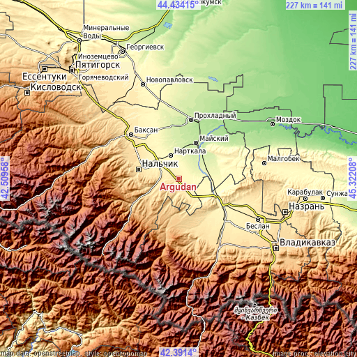
| \ | Map #1 | Map #2 | Topo.Map |
| Scale [m] | 307..495 m | 267..626 m | × |
| Scale [ft] | 1007..1624 ft | 876..2054 ft | × |
| Average | 370.2 m = 1215 ft | 387.1 m = 1270 ft | × |
| Width | 7.1 km = 4.4 mi | 14.2 km = 8.8 mi | 227.1 km = 141.1 mi |
| Height | 7.1 km = 4.4 mi | 14.2 km = 8.8 mi | 227.1 km = 141.1 mi |
| ↑Max Latitude | 43.4533° | 43.485193° | 44.43415° |
| Latitude at center | 43.42139° | 43.42139° | 43.42139° |
| ↓Min Latitude | 43.389463° | 43.35752° | 42.3914° |
| ← Min Longitude | 43.871885° | 43.827939° | 42.50958° |
| Longitude center | 43.91583° | 43.91583° | 43.91583° |
| →Max Longitude | 43.959775° | 44.003721° | 45.32208° |
Nearby cities:
Cities around Argudan sort by population:
• Nartkala elevation 291 m
16 km,  340°
340°
• Terek 260 m
19.1 km,  68°
68°
• Nartan 386 m
20.1 km,  299°
299°
• Kakhun 297 m
13.9 km,  346°
346°
• Psygansu 474 m
9.9 km,  268°
268°
• Staryy Cherek 384 m
7.9 km,  314°
314°
• Urvan’ 369 m
14.8 km, 302°
• Aushiger 566 m
15.1 km,  259°
259°
• Urukh 470 m
16.8 km,  147°
147°
• Kotlyarevskaya 228 m
20.6 km,  34°
34°
• Staryy Urukh 405 m
12.3 km,  137°
137°
• Nizhniy Cherek 300 m
10.2 km,  359°
359°
Multilingual:
 En español:
Argudan elevación 358 m.
 En France:
Argudan élévation 358 m.


Sources and notes:
- [note 1] Map square and city borders are not equal. Map elevation data is calculated only from area inside that square.
- [src 1] Elevation data from geonames database provided with same terms of usage.
- [src 2] The elevation map of Argudan is generated using elevation data from NASA's 3 arcsec (90m) resolution SRTM data.
- [src 3] Base (background) map © OpenStreetMap contributors tiles are generated by Geofabrik and OpenTopoMap.
Copyright & License:
This Argudan Elevation Map is licensed under CC BY-SA. You may reuse any part from this page, if you give a proper credit by linking to this URL:
 More info on terms of use page.