Armavir elevation
Armavir (Krasnodarskiy), Russia elevation is 201 meters and Armavir elevation in feet is 659 ft above sea level [src 1]. Armavir is a populated place (feature code) with elevation that is 2 meters (7 ft) bigger than average city elevation in Russia.
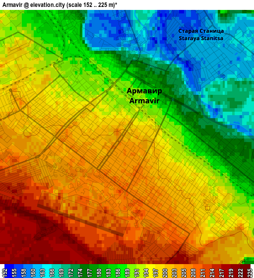
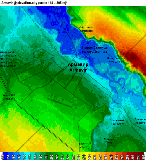
Below is the Elevation map of Armavir, which displays elevation range with different colors. Scale of the first map is from 152 to 225 m (499 to 738 ft) with average elevation of 192.3 meters (=631 ft) [note 1]
These maps also provides idea of topography and contour of this city, they are displayed at different zoom levels. More info about maps, scale and edge coordinates you can find below images.
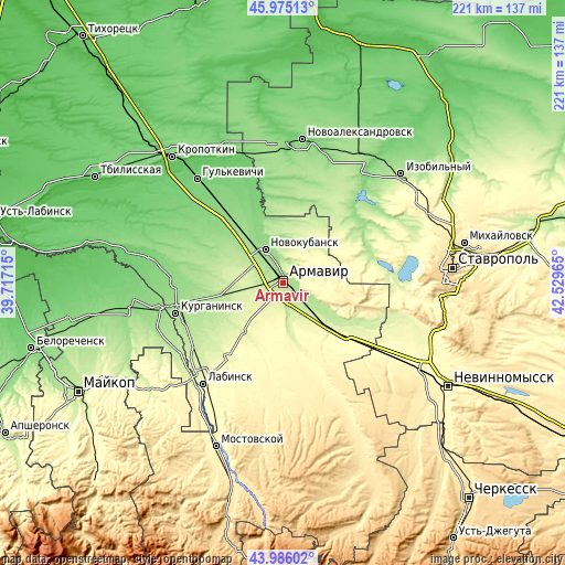
| \ | Map #1 | Map #2 | Topo.Map |
| Scale [m] | 152..225 m | 148..305 m | × |
| Scale [ft] | 499..738 ft | 486..1001 ft | × |
| Average | 192.3 m = 631 ft | 203.7 m = 668 ft | × |
| Width | 6.91 km = 4.3 mi | 13.82 km = 8.6 mi | 221.2 km = 137.4 mi |
| Height | 6.91 km = 4.3 mi | 13.82 km = 8.6 mi | 221.2 km = 137.4 mi |
| ↑Max Latitude | 45.020271° | 45.051326° | 45.97513° |
| Latitude at center | 44.9892° | 44.9892° | 44.9892° |
| ↓Min Latitude | 44.958112° | 44.927007° | 43.98602° |
| ← Min Longitude | 41.079455° | 41.035509° | 39.71715° |
| Longitude center | 41.1234° | 41.1234° | 41.1234° |
| →Max Longitude | 41.167345° | 41.211291° | 42.52965° |
Nearby cities:
Cities around Armavir sort by population:
• Novokubansk elevation 143 m
16.1 km,  331°
331°
• Uspenskoye 250 m
27.5 km,  129°
129°
• Sovetskaya 287 m
23.9 km,  170°
170°
• Konokovo 238 m
21.4 km, 131°
• Staraya Stanitsa 161 m
3.2 km,  43°
43°
• Prochnookopskaya 198 m
8.6 km,  356°
356°
• Zavetnyy 224 m
6.5 km, 170°
• Novoalekseyevskaya 241 m
24.1 km,  218°
218°
• Glubokiy 240 m
9.5 km,  240°
240°
• Prikubanskiy 165 m
4.6 km,  72°
72°
• Kovalevskoye 142 m
25.6 km, 333°
• Krasnaya Polyana 155 m
7.5 km,  347°
347°
Multilingual:
 En español:
Armavir elevación 201 m.
 En France:
Armavir élévation 201 m.


Sources and notes:
- [note 1] Map square and city borders are not equal. Map elevation data is calculated only from area inside that square.
- [src 1] Elevation data from geonames database provided with same terms of usage.
- [src 2] The elevation map of Armavir is generated using elevation data from NASA's 3 arcsec (90m) resolution SRTM data.
- [src 3] Base (background) map © OpenStreetMap contributors tiles are generated by Geofabrik and OpenTopoMap.
Copyright & License:
This Armavir Elevation Map is licensed under CC BY-SA. You may reuse any part from this page, if you give a proper credit by linking to this URL:
 More info on terms of use page.