Babayevo elevation
Babayevo (Vologda), Russia elevation is 132 meters and Babayevo elevation in feet is 433 ft above sea level [src 1]. Babayevo is a populated place (feature code) with elevation that is 67 meters (220 ft) smaller than average city elevation in Russia.
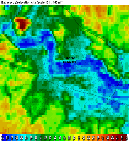
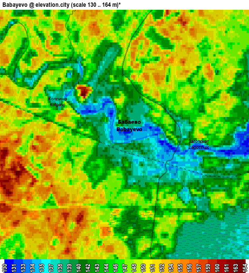
Below is the Elevation map of Babayevo, which displays elevation range with different colors. Scale of the first map is from 131 to 163 m (430 to 535 ft) with average elevation of 142.5 meters (=468 ft) [note 1]
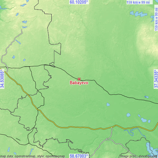
These maps also provides idea of topography and contour of this city, they are displayed at different zoom levels. More info about maps, scale and edge coordinates you can find below images.
| \ | Map #1 | Map #2 | Topo.Map |
| Scale [m] | 131..163 m | 130..164 m | × |
| Scale [ft] | 430..535 ft | 427..538 ft | × |
| Average | 142.5 m = 468 ft | 146.1 m = 479 ft | × |
| Width | 4.98 km = 3.1 mi | 9.95 km = 6.2 mi | 159.2 km = 98.9 mi |
| Height | 4.98 km = 3.1 mi | 9.95 km = 6.2 mi | 159.2 km = 98.9 mi |
| ↑Max Latitude | 59.415967° | 59.438319° | 60.10205° |
| Latitude at center | 59.3936° | 59.3936° | 59.3936° |
| ↓Min Latitude | 59.371218° | 59.348822° | 58.67003° |
| ← Min Longitude | 35.893155° | 35.849209° | 34.53085° |
| Longitude center | 35.9371° | 35.9371° | 35.9371° |
| →Max Longitude | 35.981045° | 36.024991° | 37.34335° |
Nearby cities:
Cities around Babayevo sort by population:
• Pikalëvo elevation 184 m
101 km,  277°
277°
• Pestovo 129 m
89.3 km,  184°
184°
• Kaduy 116 m
72.1 km,  107°
107°
• Ustyuzhna 118 m
67.8 km,  155°
155°
• Chagoda 136 m
43 km,  233°
233°
• Khvoynaya 164 m
97.1 km,  235°
235°
• Suda 110 m
95.9 km, 106°
• Yefimovskiy 178 m
72.4 km, 279°
• Sazonovo 136 m
52.5 km, 230°
• Khokhlovo 114 m
87.4 km, 108°
• Nelazskoye 134 m
99.3 km,  103°
103°
• Imeni Zhelyabova 111 m
61.6 km,  142°
142°
Multilingual:
 En español:
Babáyevo elevación 132 m.
 En France:
Babaïevo élévation 132 m.
 Auf Deutsch:
Babajewo höhe über dem Meeresspiegel ist 132 m.

Sources and notes:
- [note 1] Map square and city borders are not equal. Map elevation data is calculated only from area inside that square.
- [src 1] Elevation data from geonames database provided with same terms of usage.
- [src 2] The elevation map of Babayevo is generated using elevation data from NASA's 3 arcsec (90m) resolution SRTM data.
- [src 3] Base (background) map © OpenStreetMap contributors tiles are generated by Geofabrik and OpenTopoMap.
Copyright & License:
This Babayevo Elevation Map is licensed under CC BY-SA. You may reuse any part from this page, if you give a proper credit by linking to this URL:
 More info on terms of use page.