Balashov elevation
Balashov (Saratovskaya Oblast), Russia elevation is 139 meters and Balashov elevation in feet is 456 ft above sea level [src 1]. Balashov is a populated place (feature code) with elevation that is 60 meters (197 ft) smaller than average city elevation in Russia.
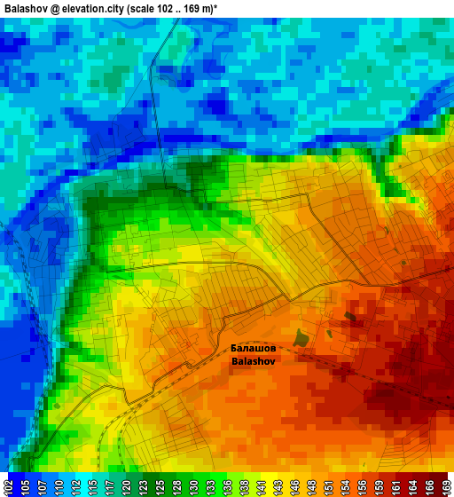
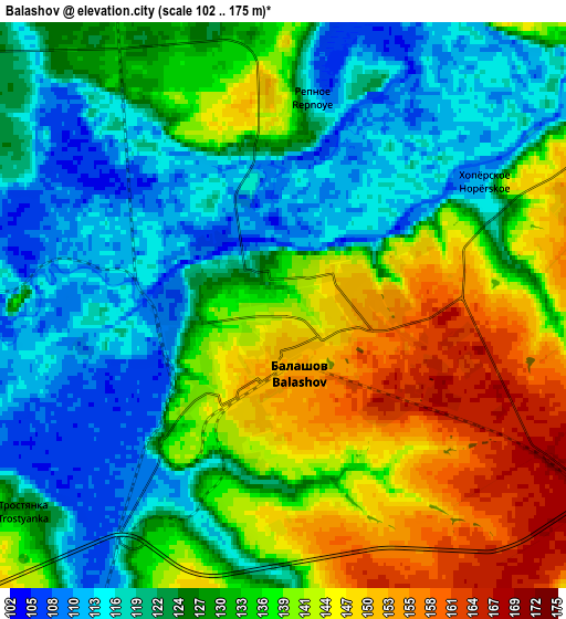
Below is the Elevation map of Balashov, which displays elevation range with different colors. Scale of the first map is from 102 to 169 m (335 to 554 ft) with average elevation of 132.6 meters (=435 ft) [note 1]
These maps also provides idea of topography and contour of this city, they are displayed at different zoom levels. More info about maps, scale and edge coordinates you can find below images.
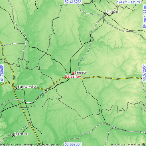
| \ | Map #1 | Map #2 | Topo.Map |
| Scale [m] | 102..169 m | 102..175 m | × |
| Scale [ft] | 335..554 ft | 335..574 ft | × |
| Average | 132.6 m = 435 ft | 130.7 m = 429 ft | × |
| Width | 6.08 km = 3.8 mi | 12.15 km = 7.5 mi | 194.5 km = 120.9 mi |
| Height | 6.08 km = 3.8 mi | 12.15 km = 7.5 mi | 194.4 km = 120.8 mi |
| ↑Max Latitude | 51.577518° | 51.60482° | 52.41626° |
| Latitude at center | 51.5502° | 51.5502° | 51.5502° |
| ↓Min Latitude | 51.522865° | 51.495514° | 50.66733° |
| ← Min Longitude | 43.122755° | 43.078809° | 41.76045° |
| Longitude center | 43.1667° | 43.1667° | 43.1667° |
| →Max Longitude | 43.210645° | 43.254591° | 44.57295° |
Nearby cities:
Cities around Balashov sort by population:
• Borisoglebsk elevation 106 m
77.7 km,  254°
254°
• Povorino 118 m
75.2 km,  238°
238°
• Yelan’ 118 m
77.8 km,  149°
149°
• Arkadak 134 m
48.2 km,  28°
28°
• Kamenka 155 m
37.5 km,  227°
227°
• Samoylovka 128 m
55.4 km,  137°
137°
• Muchkapskiy 109 m
58.4 km,  304°
304°
• Romanovka 113 m
35.8 km,  307°
307°
• Turki 165 m
49.1 km,  8°
8°
• Pinerovka 109 m
6.9 km,  280°
280°
• Repnoye 115 m
4.8 km,  16°
16°
• Bol’shoy Karay 163 m
33.5 km, 280°
Multilingual:
 En español:
Balashov elevación 139 m.
 En France:
Balashov élévation 139 m.
 Auf Deutsch:
Balaschow höhe über dem Meeresspiegel ist 139 m.

Sources and notes:
- [note 1] Map square and city borders are not equal. Map elevation data is calculated only from area inside that square.
- [src 1] Elevation data from geonames database provided with same terms of usage.
- [src 2] The elevation map of Balashov is generated using elevation data from NASA's 3 arcsec (90m) resolution SRTM data.
- [src 3] Base (background) map © OpenStreetMap contributors tiles are generated by Geofabrik and OpenTopoMap.
Copyright & License:
This Balashov Elevation Map is licensed under CC BY-SA. You may reuse any part from this page, if you give a proper credit by linking to this URL:
 More info on terms of use page.