Bashmakovo elevation
Bashmakovo (Penza), Russia elevation is 199 meters and Bashmakovo elevation in feet is 653 ft above sea level [src 1]. Bashmakovo is a populated place (feature code) with elevation that is 0 meters (0 ft) bigger than average city elevation in Russia.
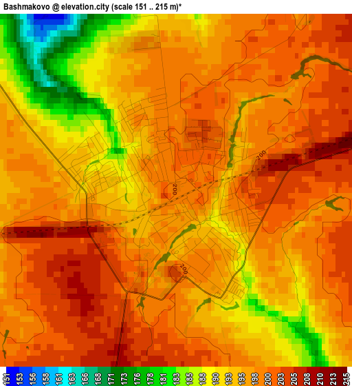
Below is the Elevation map of Bashmakovo, which displays elevation range with different colors. Scale of the first map is from 151 to 215 m (495 to 705 ft) with average elevation of 196.5 meters (=645 ft) [note 1]
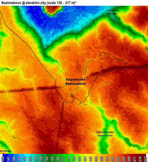
These maps also provides idea of topography and contour of this city, they are displayed at different zoom levels. More info about maps, scale and edge coordinates you can find below images.
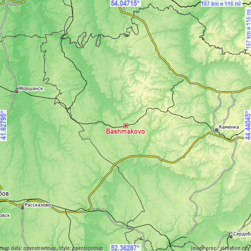
| \ | Map #1 | Map #2 | Topo.Map |
| Scale [m] | 151..215 m | 138..217 m | × |
| Scale [ft] | 495..705 ft | 453..712 ft | × |
| Average | 196.5 m = 645 ft | 191.1 m = 627 ft | × |
| Width | 5.85 km = 3.6 mi | 11.7 km = 7.3 mi | 187.3 km = 116.4 mi |
| Height | 5.85 km = 3.6 mi | 11.7 km = 7.3 mi | 187.3 km = 116.4 mi |
| ↑Max Latitude | 53.239598° | 53.26589° | 54.04715° |
| Latitude at center | 53.21329° | 53.21329° | 53.21329° |
| ↓Min Latitude | 53.186966° | 53.160625° | 52.36287° |
| ← Min Longitude | 42.990255° | 42.946309° | 41.62795° |
| Longitude center | 43.0342° | 43.0342° | 43.0342° |
| →Max Longitude | 43.078145° | 43.122091° | 44.44045° |
Nearby cities:
Cities around Bashmakovo sort by population:
• Nizhniy Lomov elevation 175 m
55.3 km,  50°
50°
• Kirsanov 152 m
65.5 km,  198°
198°
• Zemetchino 130 m
42 km,  318°
318°
• Belinskiy 189 m
37.6 km,  137°
137°
• Pachelma 186 m
21.4 km,  80°
80°
• Vadinsk 147 m
53.2 km,  1°
1°
• Verkhniy Lomov 182 m
44.5 km, 50°
• Pichayevo 139 m
55.4 km,  272°
272°
• Poim 155 m
23.2 km,  153°
153°
• Gavrilovka Vtoraya 160 m
41.5 km,  205°
205°
• Shiringushi 132 m
72.8 km,  345°
345°
• Lermontovo 217 m
48.5 km,  120°
120°
Multilingual:
 En español:
Bashmakovo elevación 199 m.
 En France:
Bashmakovo élévation 199 m.
 Auf Deutsch:
Bashmakovo höhe über dem Meeresspiegel ist 199 m.

Sources and notes:
- [note 1] Map square and city borders are not equal. Map elevation data is calculated only from area inside that square.
- [src 1] Elevation data from geonames database provided with same terms of usage.
- [src 2] The elevation map of Bashmakovo is generated using elevation data from NASA's 3 arcsec (90m) resolution SRTM data.
- [src 3] Base (background) map © OpenStreetMap contributors tiles are generated by Geofabrik and OpenTopoMap.
Copyright & License:
This Bashmakovo Elevation Map is licensed under CC BY-SA. You may reuse any part from this page, if you give a proper credit by linking to this URL:
 More info on terms of use page.