Belaya Kalitva elevation
Belaya Kalitva (Rostov), Russia elevation is 39 meters and Belaya Kalitva elevation in feet is 128 ft above sea level [src 1]. Belaya Kalitva is a seat of a second-order administrative division (feature code) with elevation that is 160 meters (525 ft) smaller than average city elevation in Russia.
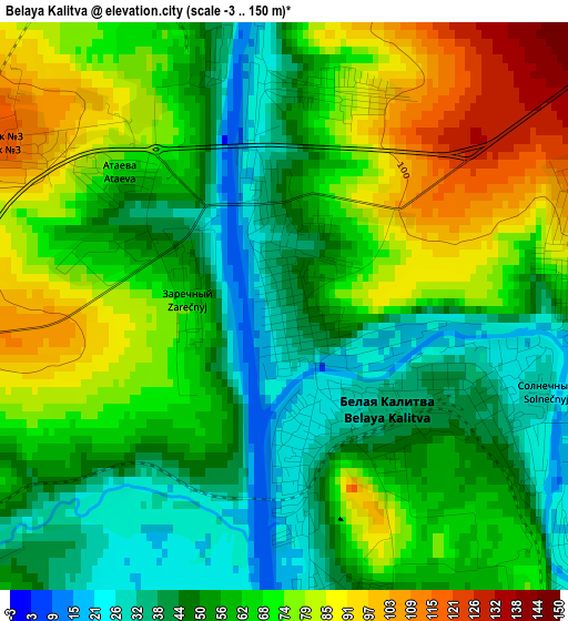
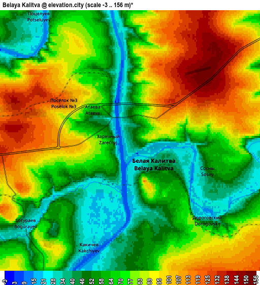
Below is the Elevation map of Belaya Kalitva, which displays elevation range with different colors. Scale of the first map is from -3 to 150 m (-10 to 492 ft) with average elevation of 61.7 meters (=202 ft) [note 1]
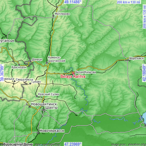
These maps also provides idea of topography and contour of this city, they are displayed at different zoom levels. More info about maps, scale and edge coordinates you can find below images.
| \ | Map #1 | Map #2 | Topo.Map |
| Scale [m] | -3..150 m | -3..156 m | × |
| Scale [ft] | -10..492 ft | -10..512 ft | × |
| Average | 61.7 m = 202 ft | 74.6 m = 245 ft | × |
| Width | 6.52 km = 4.1 mi | 13.03 km = 8.1 mi | 208.5 km = 129.6 mi |
| Height | 6.52 km = 4.1 mi | 13.03 km = 8.1 mi | 208.5 km = 129.6 mi |
| ↑Max Latitude | 48.215141° | 48.244415° | 49.11486° |
| Latitude at center | 48.18585° | 48.18585° | 48.18585° |
| ↓Min Latitude | 48.156543° | 48.127218° | 47.23969° |
| ← Min Longitude | 40.730295° | 40.686349° | 39.36799° |
| Longitude center | 40.77424° | 40.77424° | 40.77424° |
| →Max Longitude | 40.818185° | 40.862131° | 42.18049° |
Nearby cities:
Cities around Belaya Kalitva sort by population:
• Kamensk-Shakhtinskiy elevation 57 m
40.8 km,  291°
291°
• Likhovskoy 219 m
44.3 km,  265°
265°
• Tatsinskiy 82 m
37.2 km,  88°
88°
• Sholokhovskiy 153 m
22.7 km,  62°
62°
• Gornyatskiy 96 m
16.6 km,  42°
42°
• Koksovyy 91 m
9.8 km,  277°
277°
• Staraya Stanitsa 38 m
39.8 km,  296°
296°
• Sinegorskiy 67 m
19.8 km,  164°
164°
• Zhirnov 65 m
26.1 km, 93°
• Bystrogorskiy 42 m
27.3 km,  84°
84°
• Likhoy 117 m
42.7 km,  261°
261°
• Uglegorskiy 110 m
36 km, 79°
Multilingual:
 En español:
Bélaya Kalitvá elevación 39 m.
 En France:
Belaïa Kalitva élévation 39 m.
 Auf Deutsch:
Belaya Kalitva höhe über dem Meeresspiegel ist 39 m.

Sources and notes:
- [note 1] Map square and city borders are not equal. Map elevation data is calculated only from area inside that square.
- [src 1] Elevation data from geonames database provided with same terms of usage.
- [src 2] The elevation map of Belaya Kalitva is generated using elevation data from NASA's 3 arcsec (90m) resolution SRTM data.
- [src 3] Base (background) map © OpenStreetMap contributors tiles are generated by Geofabrik and OpenTopoMap.
Copyright & License:
This Belaya Kalitva Elevation Map is licensed under CC BY-SA. You may reuse any part from this page, if you give a proper credit by linking to this URL:
 More info on terms of use page.