Bezhanitsy elevation
Bezhanitsy (Pskov Oblast), Russia elevation is 117 meters and Bezhanitsy elevation in feet is 384 ft above sea level [src 1]. Bezhanitsy is a populated place (feature code) with elevation that is 82 meters (269 ft) smaller than average city elevation in Russia.
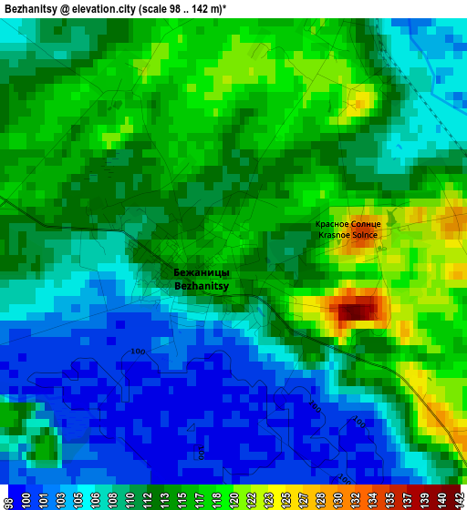
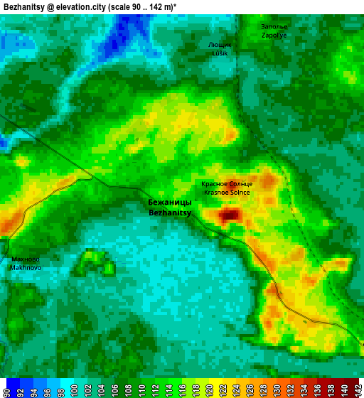
Below is the Elevation map of Bezhanitsy, which displays elevation range with different colors. Scale of the first map is from 98 to 142 m (322 to 466 ft) with average elevation of 111 meters (=364 ft) [note 1]
These maps also provides idea of topography and contour of this city, they are displayed at different zoom levels. More info about maps, scale and edge coordinates you can find below images.
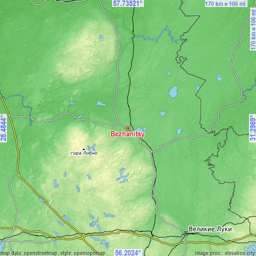
| \ | Map #1 | Map #2 | Topo.Map |
| Scale [m] | 98..142 m | 90..142 m | × |
| Scale [ft] | 322..466 ft | 295..466 ft | × |
| Average | 111 m = 364 ft | 107.7 m = 353 ft | × |
| Width | 5.33 km = 3.3 mi | 10.65 km = 6.6 mi | 170.4 km = 105.9 mi |
| Height | 5.33 km = 3.3 mi | 10.65 km = 6.6 mi | 170.4 km = 105.9 mi |
| ↑Max Latitude | 57.000632° | 57.024558° | 57.73521° |
| Latitude at center | 56.97669° | 56.97669° | 56.97669° |
| ↓Min Latitude | 56.952733° | 56.928761° | 56.2024° |
| ← Min Longitude | 29.846705° | 29.802759° | 28.4844° |
| Longitude center | 29.89065° | 29.89065° | 29.89065° |
| →Max Longitude | 29.934595° | 29.978541° | 31.2969° |
Nearby cities:
Cities around Bezhanitsy sort by population:
• Dedovichi elevation 85 m
64 km,  3°
3°
• Novosokol’niki 132 m
72 km,  166°
166°
• Pushkinskiye Gory 138 m
59.6 km,  274°
274°
• Loknya 119 m
22.5 km,  136°
136°
• Novorzhev 74 m
34.2 km,  279°
279°
• Vybor 82 m
51.9 km,  302°
302°
• Krasnyy Luch 103 m
15.7 km,  50°
50°
• Laptëvo 109 m
69.3 km,  247°
247°
• Glubokoye 199 m
66.9 km,  232°
232°
• Norkino 188 m
62.7 km,  236°
236°
• Polyane 122 m
61.9 km,  260°
260°
• Bolgatovo 102 m
60.4 km, 251°
Multilingual:
 En español:
Bezhanitsy elevación 117 m.
 En France:
Bezhanitsy élévation 117 m.
 Auf Deutsch:
Bezhanitsy höhe über dem Meeresspiegel ist 117 m.

Sources and notes:
- [note 1] Map square and city borders are not equal. Map elevation data is calculated only from area inside that square.
- [src 1] Elevation data from geonames database provided with same terms of usage.
- [src 2] The elevation map of Bezhanitsy is generated using elevation data from NASA's 3 arcsec (90m) resolution SRTM data.
- [src 3] Base (background) map © OpenStreetMap contributors tiles are generated by Geofabrik and OpenTopoMap.
Copyright & License:
This Bezhanitsy Elevation Map is licensed under CC BY-SA. You may reuse any part from this page, if you give a proper credit by linking to this URL:
 More info on terms of use page.