Bol’shaya Izhora elevation
Bol’shaya Izhora (Leningradskaya Oblast'), Russia elevation is 8 meters and Bol’shaya Izhora elevation in feet is 26 ft above sea level [src 1]. Bol’shaya Izhora is a populated place (feature code) with elevation that is 191 meters (627 ft) smaller than average city elevation in Russia.
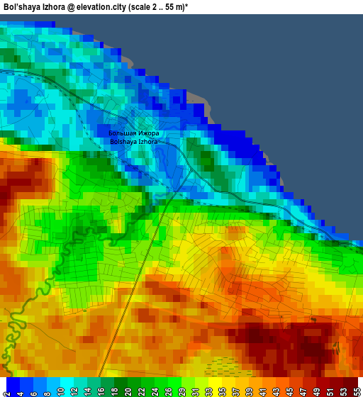
Below is the Elevation map of Bol’shaya Izhora, which displays elevation range with different colors. Scale of the first map is from 2 to 55 m (7 to 180 ft) with average elevation of 28.3 meters (=93 ft) [note 1]
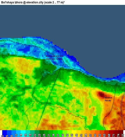
These maps also provides idea of topography and contour of this city, they are displayed at different zoom levels. More info about maps, scale and edge coordinates you can find below images.
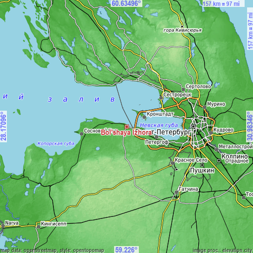
| \ | Map #1 | Map #2 | Topo.Map |
| Scale [m] | 2..55 m | 2..77 m | × |
| Scale [ft] | 7..180 ft | 7..253 ft | × |
| Average | 28.3 m = 93 ft | 37.1 m = 122 ft | × |
| Width | 4.9 km = 3 mi | 9.79 km = 6.1 mi | 156.7 km = 97.4 mi |
| Height | 4.9 km = 3 mi | 9.79 km = 6.1 mi | 156.6 km = 97.3 mi |
| ↑Max Latitude | 59.959967° | 59.981958° | 60.63496° |
| Latitude at center | 59.93796° | 59.93796° | 59.93796° |
| ↓Min Latitude | 59.915939° | 59.893903° | 59.226° |
| ← Min Longitude | 29.533265° | 29.489319° | 28.17096° |
| Longitude center | 29.57721° | 29.57721° | 29.57721° |
| →Max Longitude | 29.621155° | 29.665101° | 30.98346° |
Nearby cities:
Cities around Bol’shaya Izhora sort by population:
• Peterhof elevation 26 m
19 km,  108°
108°
• Petrodvorets 28 m
13.4 km, 110°
• Kronshtadt 8 m
12.3 km,  58°
58°
• Lomonosov 30 m
11.4 km, 108°
• Ol’gino 28 m
22.3 km,  120°
120°
• Gorbunki 26 m
26.6 km, 121°
• Tarkhovka 7 m
26.3 km, 57°
• Lebyazh’ye 12 m
9.4 km,  285°
285°
• Lisiy Nos 41 m
26.2 km,  70°
70°
• Aleksandrovskaya 1 m
25.7 km, 60°
• Gorskaya 7 m
25 km, 61°
• Gostilitsy 134 m
21.2 km,  173°
173°
Multilingual:
 En español:
Bol’shaya Izhora elevación 8 m.
 En France:
Bol’shaya Izhora élévation 8 m.
 Auf Deutsch:
Bol’shaya Izhora höhe über dem Meeresspiegel ist 8 m.

Sources and notes:
- [note 1] Map square and city borders are not equal. Map elevation data is calculated only from area inside that square.
- [src 1] Elevation data from geonames database provided with same terms of usage.
- [src 2] The elevation map of Bol’shaya Izhora is generated using elevation data from NASA's 3 arcsec (90m) resolution SRTM data.
- [src 3] Base (background) map © OpenStreetMap contributors tiles are generated by Geofabrik and OpenTopoMap.
Copyright & License:
This Bol’shaya Izhora Elevation Map is licensed under CC BY-SA. You may reuse any part from this page, if you give a proper credit by linking to this URL:
 More info on terms of use page.