Bugul’ma elevation
Bugul’ma (Tatarstan Republic, Bugul’minskiy Rayon), Russia elevation is 292 meters and Bugul’ma elevation in feet is 958 ft above sea level [src 1]. Bugul’ma is a populated place (feature code) with elevation that is 93 meters (305 ft) bigger than average city elevation in Russia.
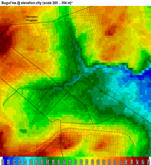
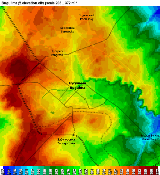
Below is the Elevation map of Bugul’ma, which displays elevation range with different colors. Scale of the first map is from 265 to 354 m (869 to 1161 ft) with average elevation of 312.6 meters (=1026 ft) [note 1]
These maps also provides idea of topography and contour of this city, they are displayed at different zoom levels. More info about maps, scale and edge coordinates you can find below images.
| \ | Map #1 | Map #2 | Topo.Map |
| Scale [m] | 265..354 m | 205..372 m | × |
| Scale [ft] | 869..1161 ft | 673..1220 ft | × |
| Average | 312.6 m = 1026 ft | 307.7 m = 1010 ft | × |
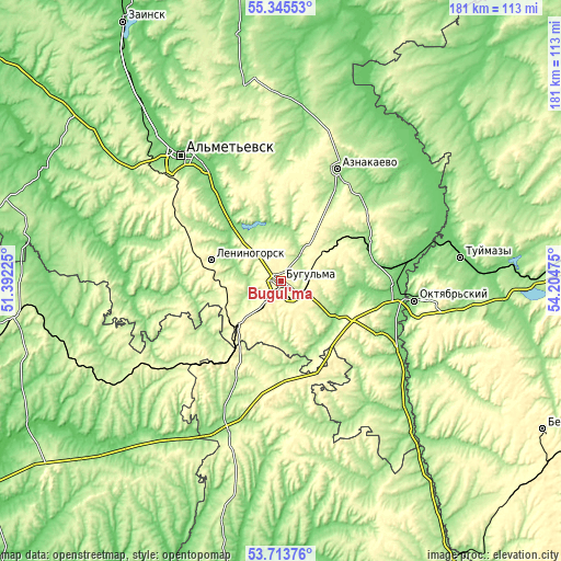
| Width | 5.67 km = 3.5 mi | 11.34 km = 7 mi | 181.4 km = 112.7 mi |
| Height | 5.67 km = 3.5 mi | 11.34 km = 7 mi | 181.4 km = 112.7 mi |
| ↑Max Latitude | 54.563288° | 54.588759° | 55.34553° |
| Latitude at center | 54.5378° | 54.5378° | 54.5378° |
| ↓Min Latitude | 54.512296° | 54.486777° | 53.71376° |
| ← Min Longitude | 52.754555° | 52.710609° | 51.39225° |
| Longitude center | 52.7985° | 52.7985° | 52.7985° |
| →Max Longitude | 52.842445° | 52.886391° | 54.20475° |
Nearby cities:
Cities around Bugul’ma sort by population:
• Al’met’yevsk elevation 121 m
51.2 km,  322°
322°
• Oktyabr’skiy 133 m
43.9 km,  98°
98°
• Leninogorsk 223 m
22.9 km,  288°
288°
• Bavly 180 m
33.9 km,  118°
118°
• Dzhalil’ 288 m
54.2 km,  355°
355°
• Urussu 107 m
43.4 km,  81°
81°
• Nizhnyaya Maktama 110 m
43.3 km,  326°
326°
• Aktyubinskiy 307 m
30.7 km,  0°
0°
• Klyavlino 241 m
58.4 km,  238°
238°
• Karabash 144 m
22.1 km, 321°
• Severnoye 197 m
52.1 km,  198°
198°
• Shugurovo 129 m
43.1 km,  265°
265°
Multilingual:
 En español:
Bugul’ma elevación 292 m.
 En France:
Bugul’ma élévation 292 m.
 Auf Deutsch:
Bugul’ma höhe über dem Meeresspiegel ist 292 m.

Sources and notes:
- [note 1] Map square and city borders are not equal. Map elevation data is calculated only from area inside that square.
- [src 1] Elevation data from geonames database provided with same terms of usage.
- [src 2] The elevation map of Bugul’ma is generated using elevation data from NASA's 3 arcsec (90m) resolution SRTM data.
- [src 3] Base (background) map © OpenStreetMap contributors tiles are generated by Geofabrik and OpenTopoMap.
Copyright & License:
This Bugul’ma Elevation Map is licensed under CC BY-SA. You may reuse any part from this page, if you give a proper credit by linking to this URL:
 More info on terms of use page.