Chornoye elevation
Chornoye (Moscow Oblast, Balashikha Urban Okrug), Russia elevation is 137 meters and Chornoye elevation in feet is 449 ft above sea level [src 1]. Chornoye is a populated place (feature code) with elevation that is 62 meters (203 ft) smaller than average city elevation in Russia.
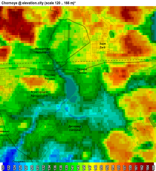
Below is the Elevation map of Chornoye, which displays elevation range with different colors. Scale of the first map is from 120 to 166 m (394 to 545 ft) with average elevation of 142.8 meters (=469 ft) [note 1]
These maps also provides idea of topography and contour of this city, they are displayed at different zoom levels. More info about maps, scale and edge coordinates you can find below images.
| \ | Map #1 | Map #2 | Topo.Map |
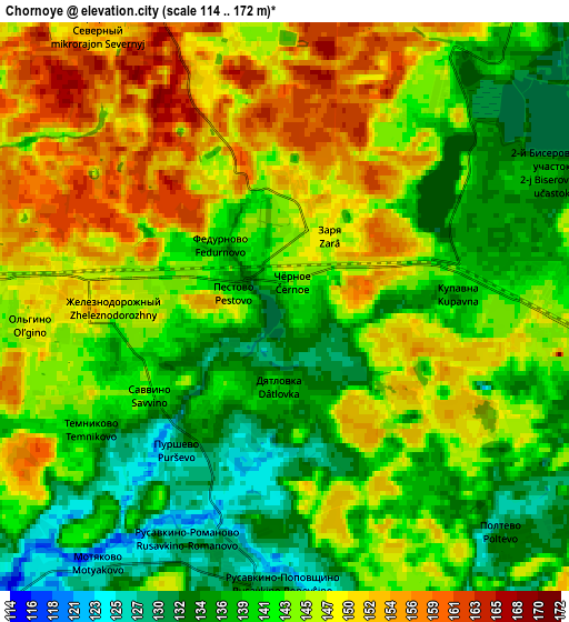
| Scale [m] | 120..166 m | 114..172 m | × |
| Scale [ft] | 394..545 ft | 374..564 ft | × |
| Average | 142.8 m = 469 ft | 143.4 m = 470 ft | × |
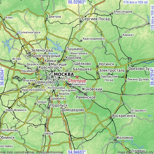
| Width | 5.5 km = 3.4 mi | 11 km = 6.8 mi | 176 km = 109.4 mi |
| Height | 5.5 km = 3.4 mi | 11 km = 6.8 mi | 176 km = 109.4 mi |
| ↑Max Latitude | 55.770837° | 55.795549° | 56.52963° |
| Latitude at center | 55.74611° | 55.74611° | 55.74611° |
| ↓Min Latitude | 55.721367° | 55.696608° | 54.94653° |
| ← Min Longitude | 38.024945° | 37.980999° | 36.66264° |
| Longitude center | 38.06889° | 38.06889° | 38.06889° |
| →Max Longitude | 38.112835° | 38.156781° | 39.47514° |
Nearby cities:
Cities around Chornoye sort by population:
• Balashikha elevation 147 m
9.9 km,  315°
315°
• Zheleznodorozhnyy 146 m
3.3 km,  265°
265°
• Zarya 158 m
2 km,  58°
58°
• Staraya Kupavna 145 m
9.8 km,  45°
45°
• Elektrougli 145 m
9.1 km,  105°
105°
• Kupavna 143 m
3.9 km,  90°
90°
• Korenëvo 132 m
9.1 km,  204°
204°
• Saltykovka 150 m
8.7 km,  285°
285°
• Rodniki 134 m
10.5 km,  180°
180°
• Purshevo 127 m
3.6 km,  219°
219°
• Fedurnovo 140 m
1.7 km,  305°
305°
• Vishnyakovskiye Dachi 135 m
4.5 km, 62°
Multilingual:
 En español:
Chornoye elevación 137 m.
 En France:
Chornoye élévation 137 m.
 Auf Deutsch:
Chornoye höhe über dem Meeresspiegel ist 137 m.

Sources and notes:
- [note 1] Map square and city borders are not equal. Map elevation data is calculated only from area inside that square.
- [src 1] Elevation data from geonames database provided with same terms of usage.
- [src 2] The elevation map of Chornoye is generated using elevation data from NASA's 3 arcsec (90m) resolution SRTM data.
- [src 3] Base (background) map © OpenStreetMap contributors tiles are generated by Geofabrik and OpenTopoMap.
Copyright & License:
This Chornoye Elevation Map is licensed under CC BY-SA. You may reuse any part from this page, if you give a proper credit by linking to this URL:
 More info on terms of use page.