Dachnoye elevation
Dachnoye (St.-Petersburg, Kirovskiy Rayon), Russia elevation is 15 meters and Dachnoye elevation in feet is 49 ft above sea level [src 1]. Dachnoye is a section of populated place (feature code) with elevation that is 184 meters (604 ft) smaller than average city elevation in Russia.
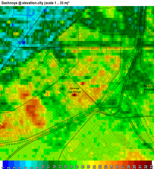
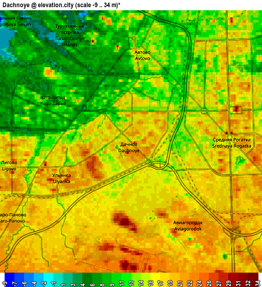
Below is the Elevation map of Dachnoye, which displays elevation range with different colors. Scale of the first map is from 1 to 33 m (3 to 108 ft) with average elevation of 15.7 meters (=52 ft) [note 1]
These maps also provides idea of topography and contour of this city, they are displayed at different zoom levels. More info about maps, scale and edge coordinates you can find below images.
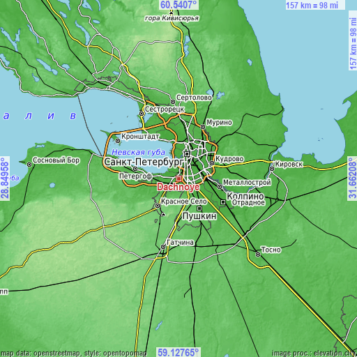
| \ | Map #1 | Map #2 | Topo.Map |
| Scale [m] | 1..33 m | -9..34 m | × |
| Scale [ft] | 3..108 ft | -30..112 ft | × |
| Average | 15.7 m = 52 ft | 15.5 m = 51 ft | × |
| Width | 4.91 km = 3.1 mi | 9.82 km = 6.1 mi | 157.1 km = 97.6 mi |
| Height | 4.91 km = 3.1 mi | 9.82 km = 6.1 mi | 157.1 km = 97.6 mi |
| ↑Max Latitude | 59.86374° | 59.885796° | 60.5407° |
| Latitude at center | 59.84167° | 59.84167° | 59.84167° |
| ↓Min Latitude | 59.819585° | 59.797485° | 59.12765° |
| ← Min Longitude | 30.211885° | 30.167939° | 28.84958° |
| Longitude center | 30.25583° | 30.25583° | 30.25583° |
| →Max Longitude | 30.299775° | 30.343721° | 31.66208° |
Nearby cities:
Cities around Dachnoye sort by population:
• Saint Petersburg elevation 11 m
11.3 km,  16°
16°
• Centralniy 18 m
11.5 km,  30°
30°
• Vasyl'evsky Ostrov 7 m
11 km,  359°
359°
• Admiralteisky 9 m
7.6 km,  12°
12°
• Uritsk 18 m
4.5 km,  266°
266°
• Kupchino 17 m
5.8 km,  77°
77°
• Sosnovaya Polyana 17 m
6.1 km,  263°
263°
• Obukhovo 14 m
10.9 km,  88°
88°
• Avtovo 14 m
3.4 km, 9°
• Gorelovo 47 m
10.3 km,  221°
221°
• Shushary 24 m
7.9 km,  117°
117°
• Strel'na 22 m
12.3 km,  275°
275°
Multilingual:
 En español:
Dachnoye elevación 15 m.
 En France:
Dachnoye élévation 15 m.


Sources and notes:
- [note 1] Map square and city borders are not equal. Map elevation data is calculated only from area inside that square.
- [src 1] Elevation data from geonames database provided with same terms of usage.
- [src 2] The elevation map of Dachnoye is generated using elevation data from NASA's 3 arcsec (90m) resolution SRTM data.
- [src 3] Base (background) map © OpenStreetMap contributors tiles are generated by Geofabrik and OpenTopoMap.
Copyright & License:
This Dachnoye Elevation Map is licensed under CC BY-SA. You may reuse any part from this page, if you give a proper credit by linking to this URL:
 More info on terms of use page.