Demyansk elevation
Demyansk (Novgorod Oblast), Russia elevation is 52 meters and Demyansk elevation in feet is 171 ft above sea level [src 1]. Demyansk is a populated place (feature code) with elevation that is 147 meters (482 ft) smaller than average city elevation in Russia.
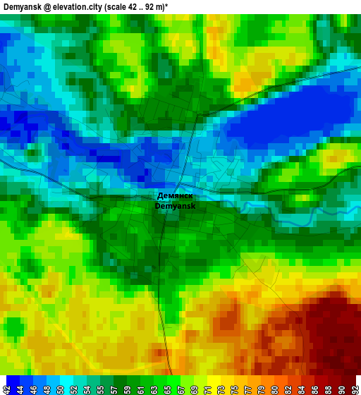
Below is the Elevation map of Demyansk, which displays elevation range with different colors. Scale of the first map is from 42 to 92 m (138 to 302 ft) with average elevation of 62.4 meters (=205 ft) [note 1]
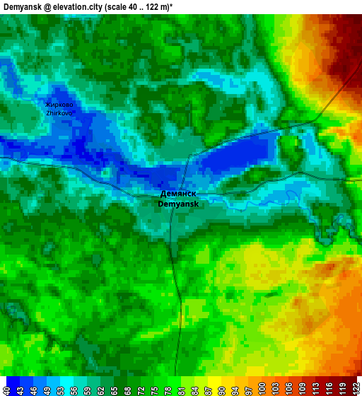
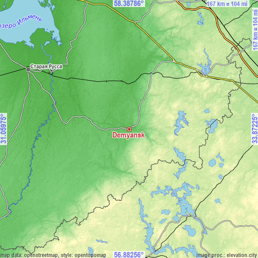
These maps also provides idea of topography and contour of this city, they are displayed at different zoom levels. More info about maps, scale and edge coordinates you can find below images.
| \ | Map #1 | Map #2 | Topo.Map |
| Scale [m] | 42..92 m | 40..122 m | × |
| Scale [ft] | 138..302 ft | 131..400 ft | × |
| Average | 62.4 m = 205 ft | 70.8 m = 232 ft | × |
| Width | 5.23 km = 3.2 mi | 10.46 km = 6.5 mi | 167.4 km = 104 mi |
| Height | 5.23 km = 3.2 mi | 10.46 km = 6.5 mi | 167.4 km = 104 mi |
| ↑Max Latitude | 57.666522° | 57.690018° | 58.38786° |
| Latitude at center | 57.64301° | 57.64301° | 57.64301° |
| ↓Min Latitude | 57.619483° | 57.595941° | 56.88256° |
| ← Min Longitude | 32.422055° | 32.378109° | 31.05975° |
| Longitude center | 32.466° | 32.466° | 32.466° |
| →Max Longitude | 32.509945° | 32.553891° | 33.87225° |
Nearby cities:
Cities around Demyansk sort by population:
• Staraya Russa elevation 27 m
76.2 km,  300°
300°
• Ostashkov 210 m
67.3 km,  145°
145°
• Valday 212 m
59.4 km,  51°
51°
• Bologoye-4 203 m
75.8 km,  67°
67°
• Kresttsy 68 m
67 km,  2°
2°
• Parfino 28 m
60.8 km,  307°
307°
• Peno 215 m
81.4 km,  168°
168°
• Firovo 212 m
75.9 km,  103°
103°
• Marevo 115 m
43.2 km,  212°
212°
• Vypolzovo 188 m
77.6 km, 70°
• Poddor’ye 74 m
82.8 km,  256°
256°
• Yedrovo 199 m
74.7 km, 66°
Multilingual:
 En español:
Demyansk elevación 52 m.
 En France:
Demyansk élévation 52 m.


Sources and notes:
- [note 1] Map square and city borders are not equal. Map elevation data is calculated only from area inside that square.
- [src 1] Elevation data from geonames database provided with same terms of usage.
- [src 2] The elevation map of Demyansk is generated using elevation data from NASA's 3 arcsec (90m) resolution SRTM data.
- [src 3] Base (background) map © OpenStreetMap contributors tiles are generated by Geofabrik and OpenTopoMap.
Copyright & License:
This Demyansk Elevation Map is licensed under CC BY-SA. You may reuse any part from this page, if you give a proper credit by linking to this URL:
 More info on terms of use page.