Gadzhiyevo elevation
Gadzhiyevo (Murmansk), Russia elevation is 34 meters and Gadzhiyevo elevation in feet is 112 ft above sea level [src 1]. Gadzhiyevo is a populated place (feature code) with elevation that is 165 meters (541 ft) smaller than average city elevation in Russia.
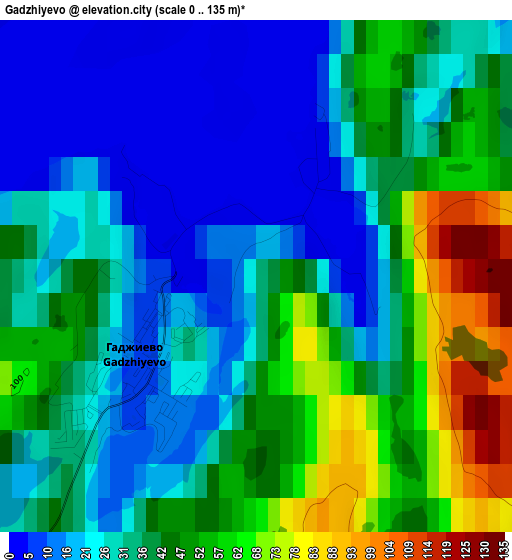
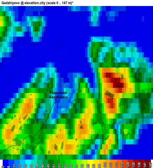
Below is the Elevation map of Gadzhiyevo, which displays elevation range with different colors. Scale of the first map is from 0 to 135 m (0 to 443 ft) with average elevation of 36.2 meters (=119 ft) [note 1]
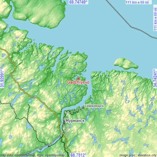
These maps also provides idea of topography and contour of this city, they are displayed at different zoom levels. More info about maps, scale and edge coordinates you can find below images.
| \ | Map #1 | Map #2 | Topo.Map |
| Scale [m] | 0..135 m | 0..147 m | × |
| Scale [ft] | 0..443 ft | 0..482 ft | × |
| Average | 36.2 m = 119 ft | 35.3 m = 116 ft | × |
| Width | 3.46 km = 2.1 mi | 6.92 km = 4.3 mi | 110.8 km = 68.8 mi |
| Height | 3.46 km = 2.1 mi | 6.92 km = 4.3 mi | 110.8 km = 68.8 mi |
| ↑Max Latitude | 69.27062° | 69.286169° | 69.74749° |
| Latitude at center | 69.25506° | 69.25506° | 69.25506° |
| ↓Min Latitude | 69.239489° | 69.223906° | 68.7512° |
| ← Min Longitude | 33.292215° | 33.248269° | 31.92991° |
| Longitude center | 33.33616° | 33.33616° | 33.33616° |
| →Max Longitude | 33.380105° | 33.424051° | 34.74241° |
Nearby cities:
Cities around Gadzhiyevo sort by population:
• Murmansk elevation 96 m
32.2 km,  197°
197°
• Severomorsk 17 m
20.9 km,  171°
171°
• Polyarnyy 15 m
7.6 km,  144°
144°
• Zaozërsk 53 m
38.4 km,  294°
294°
• Snezhnogorsk 74 m
7.6 km,  205°
205°
• Kola 12 m
43.5 km, 196°
• Roslyakovo 1 m
24.2 km,  192°
192°
• Vidyayevo 1 m
22.1 km, 288°
• Vidyayevo 12 m
43.2 km, 197°
• Safonovo 38 m
21.7 km,  184°
184°
• Severomorsk-3 120 m
44.6 km,  159°
159°
• Abram Mys 1 m
33.2 km, 202°
Multilingual:
 En español:
Gadzhiyevo elevación 34 m.
 En France:
Gadjievo élévation 34 m.
 Auf Deutsch:
Gadschijewo höhe über dem Meeresspiegel ist 34 m.

Sources and notes:
- [note 1] Map square and city borders are not equal. Map elevation data is calculated only from area inside that square.
- [src 1] Elevation data from geonames database provided with same terms of usage.
- [src 2] The elevation map of Gadzhiyevo is generated using GMTED2010 database with 7.5 arcsec (225m) resolution.
- [src 3] Base (background) map © OpenStreetMap contributors tiles are generated by Geofabrik and OpenTopoMap.
Copyright & License:
This Gadzhiyevo Elevation Map is licensed under CC BY-SA. You may reuse any part from this page, if you give a proper credit by linking to this URL:
 More info on terms of use page.