Kamyshin elevation
Kamyshin (Volgograd Oblast), Russia elevation is 73 meters and Kamyshin elevation in feet is 240 ft above sea level [src 1]. Kamyshin is a populated place (feature code) with elevation that is 126 meters (413 ft) smaller than average city elevation in Russia.
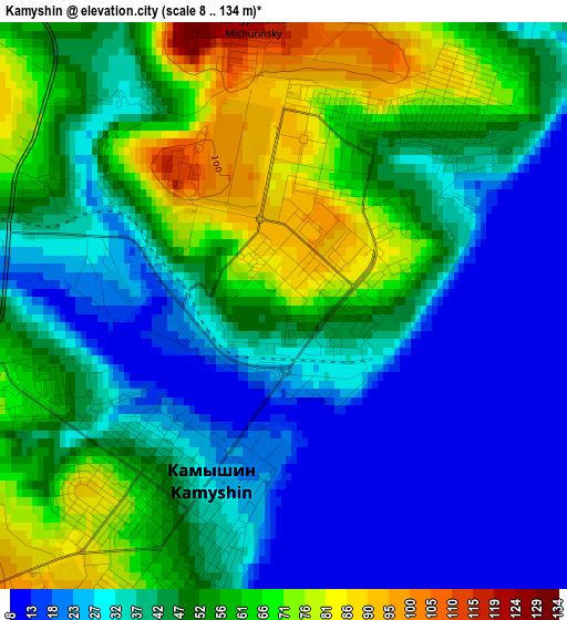
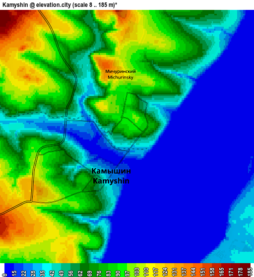
Below is the Elevation map of Kamyshin, which displays elevation range with different colors. Scale of the first map is from 8 to 134 m (26 to 440 ft) with average elevation of 44 meters (=144 ft) [note 1]
These maps also provides idea of topography and contour of this city, they are displayed at different zoom levels. More info about maps, scale and edge coordinates you can find below images.
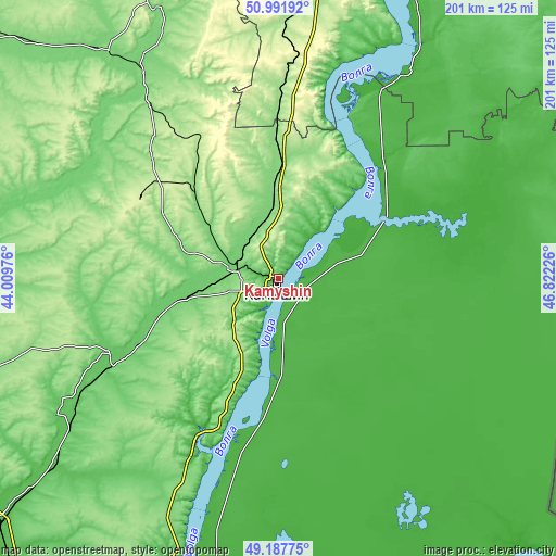
| \ | Map #1 | Map #2 | Topo.Map |
| Scale [m] | 8..134 m | 8..185 m | × |
| Scale [ft] | 26..440 ft | 26..607 ft | × |
| Average | 44 m = 144 ft | 56 m = 184 ft | × |
| Width | 6.27 km = 3.9 mi | 12.54 km = 7.8 mi | 200.6 km = 124.6 mi |
| Height | 6.27 km = 3.9 mi | 12.54 km = 7.8 mi | 200.6 km = 124.6 mi |
| ↑Max Latitude | 50.126511° | 50.154676° | 50.99192° |
| Latitude at center | 50.09833° | 50.09833° | 50.09833° |
| ↓Min Latitude | 50.070132° | 50.041917° | 49.18775° |
| ← Min Longitude | 45.372065° | 45.328119° | 44.00976° |
| Longitude center | 45.41601° | 45.41601° | 45.41601° |
| →Max Longitude | 45.459955° | 45.503901° | 46.82226° |
Nearby cities:
Cities around Kamyshin sort by population:
• Kotovo elevation 148 m
50.3 km,  299°
299°
• Nikolayevsk 30 m
8.4 km,  158°
158°
• Petrov Val 108 m
15.5 km,  288°
288°
• Bykovo 38 m
37 km,  183°
183°
• Krasnyy Yar 106 m
82.5 km,  323°
323°
• Rovnoye 20 m
87.8 km,  30°
30°
• Staraya Poltavka 19 m
86.6 km,  60°
60°
• Kamenskiy 194 m
87.7 km,  3°
3°
• Primorsk 20 m
96.7 km,  196°
196°
• Antipovka 42 m
30.8 km,  193°
193°
• Gornyy Balykley 53 m
65.9 km, 202°
• Medveditskiy 108 m
91.2 km,  326°
326°
Multilingual:
 En español:
Kamyshin elevación 73 m.
 En France:
Kamychine élévation 73 m.
 Auf Deutsch:
Kamyschin höhe über dem Meeresspiegel ist 73 m.

Sources and notes:
- [note 1] Map square and city borders are not equal. Map elevation data is calculated only from area inside that square.
- [src 1] Elevation data from geonames database provided with same terms of usage.
- [src 2] The elevation map of Kamyshin is generated using elevation data from NASA's 3 arcsec (90m) resolution SRTM data.
- [src 3] Base (background) map © OpenStreetMap contributors tiles are generated by Geofabrik and OpenTopoMap.
Copyright & License:
This Kamyshin Elevation Map is licensed under CC BY-SA. You may reuse any part from this page, if you give a proper credit by linking to this URL:
 More info on terms of use page.