Kapotnya elevation
Kapotnya (Moscow), Russia elevation is 140 meters and Kapotnya elevation in feet is 459 ft above sea level [src 1]. Kapotnya is a section of populated place (feature code) with elevation that is 59 meters (194 ft) smaller than average city elevation in Russia.
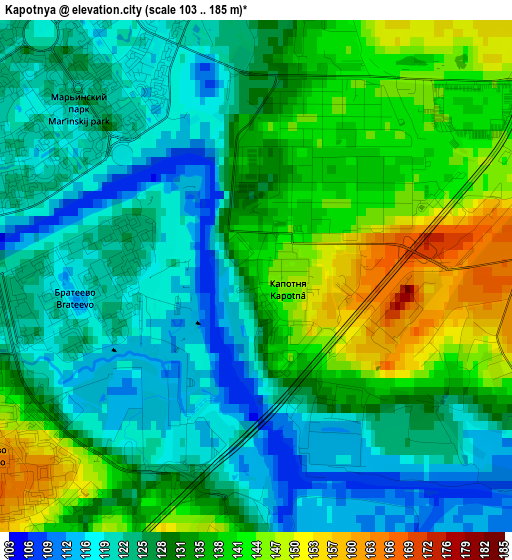
Below is the Elevation map of Kapotnya, which displays elevation range with different colors. Scale of the first map is from 103 to 185 m (338 to 607 ft) with average elevation of 130.6 meters (=428 ft) [note 1]
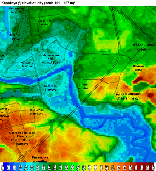
These maps also provides idea of topography and contour of this city, they are displayed at different zoom levels. More info about maps, scale and edge coordinates you can find below images.

| \ | Map #1 | Map #2 | Topo.Map |
| Scale [m] | 103..185 m | 101..197 m | × |
| Scale [ft] | 338..607 ft | 331..646 ft | × |
| Average | 130.6 m = 428 ft | 138.6 m = 455 ft | × |
| Width | 5.52 km = 3.4 mi | 11.03 km = 6.9 mi | 176.5 km = 109.7 mi |
| Height | 5.52 km = 3.4 mi | 11.03 km = 6.9 mi | 176.5 km = 109.7 mi |
| ↑Max Latitude | 55.662856° | 55.687636° | 56.42376° |
| Latitude at center | 55.63806° | 55.63806° | 55.63806° |
| ↓Min Latitude | 55.613249° | 55.588421° | 54.83628° |
| ← Min Longitude | 37.749115° | 37.705169° | 36.38681° |
| Longitude center | 37.79306° | 37.79306° | 37.79306° |
| →Max Longitude | 37.837005° | 37.880951° | 39.19931° |
Nearby cities:
Cities around Kapotnya sort by population:
• Mar’ino elevation 118 m
5 km,  285°
285°
• Lyublino 141 m
4.8 km,  334°
334°
• Orekhovo-Borisovo 176 m
5.1 km,  235°
235°
• Zyablikovo 145 m
2.9 km,  214°
214°
• Brateyevo 119 m
1.8 km,  268°
268°
• Alekseyevka 142 m
1 km,  154°
154°
• Dzerzhinsky 143 m
4.2 km,  106°
106°
• Dzerzhinskiy 152 m
4.1 km,  103°
103°
• Kur’yanovo 120 m
6 km,  282°
282°
• Kotel’niki 175 m
3.2 km, 95°
• Razvilka 175 m
6.1 km, 212°
• Orekhovo-Borisovo Yuzhnoye 131 m
3.8 km,  262°
262°
Multilingual:
 En español:
Kapotnya elevación 140 m.
 En France:
Kapotnya élévation 140 m.
 Auf Deutsch:
Kapotnya höhe über dem Meeresspiegel ist 140 m.

Sources and notes:
- [note 1] Map square and city borders are not equal. Map elevation data is calculated only from area inside that square.
- [src 1] Elevation data from geonames database provided with same terms of usage.
- [src 2] The elevation map of Kapotnya is generated using elevation data from NASA's 3 arcsec (90m) resolution SRTM data.
- [src 3] Base (background) map © OpenStreetMap contributors tiles are generated by Geofabrik and OpenTopoMap.
Copyright & License:
This Kapotnya Elevation Map is licensed under CC BY-SA. You may reuse any part from this page, if you give a proper credit by linking to this URL:
 More info on terms of use page.