Karachev elevation
Karachev (Bryansk Oblast), Russia elevation is 204 meters and Karachev elevation in feet is 669 ft above sea level [src 1]. Karachev is a populated place (feature code) with elevation that is 5 meters (16 ft) bigger than average city elevation in Russia.
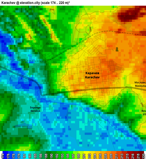
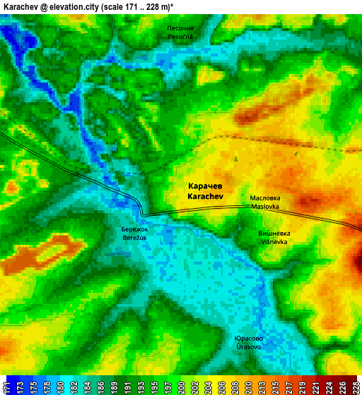
Below is the Elevation map of Karachev, which displays elevation range with different colors. Scale of the first map is from 174 to 220 m (571 to 722 ft) with average elevation of 193 meters (=633 ft) [note 1]
These maps also provides idea of topography and contour of this city, they are displayed at different zoom levels. More info about maps, scale and edge coordinates you can find below images.
| \ | Map #1 | Map #2 | Topo.Map |
| Scale [m] | 174..220 m | 171..228 m | × |
| Scale [ft] | 571..722 ft | 561..748 ft | × |
| Average | 193 m = 633 ft | 194.7 m = 639 ft | × |
| Width | 5.86 km = 3.6 mi | 11.73 km = 7.3 mi | 187.7 km = 116.6 mi |
| Height | 5.86 km = 3.6 mi | 11.73 km = 7.3 mi | 187.7 km = 116.6 mi |
| ↑Max Latitude | 53.149284° | 53.175631° | 53.95855° |
| Latitude at center | 53.12292° | 53.12292° | 53.12292° |
| ↓Min Latitude | 53.09654° | 53.070144° | 52.27072° |
| ← Min Longitude | 34.941225° | 34.897279° | 33.57892° |
| Longitude center | 34.98517° | 34.98517° | 34.98517° |
| →Max Longitude | 35.029115° | 35.073061° | 36.39142° |
Nearby cities:
Cities around Karachev sort by population:
• Bryansk elevation 206 m
43.3 km,  289°
289°
• Navlya 174 m
46.4 km,  224°
224°
• Belyye Berega 181 m
23.4 km, 293°
• Suponevo 153 m
46.8 km,  281°
281°
• Khvastovichi 179 m
39.2 km,  10°
10°
• Khotynets 217 m
27.5 km,  88°
88°
• Dobrun’ 193 m
49.8 km, 277°
• Shablykino 205 m
32.8 km,  154°
154°
• Putëvka 186 m
48.8 km, 287°
• Sven’ 182 m
29.7 km, 282°
• Raditsa-Krylovka 148 m
47 km,  297°
297°
• Soskovo 227 m
49.5 km, 147°
Multilingual:
 En español:
Karachev elevación 204 m.
 En France:
Karachev élévation 204 m.
 Auf Deutsch:
Karachev höhe über dem Meeresspiegel ist 204 m.

Sources and notes:
- [note 1] Map square and city borders are not equal. Map elevation data is calculated only from area inside that square.
- [src 1] Elevation data from geonames database provided with same terms of usage.
- [src 2] The elevation map of Karachev is generated using elevation data from NASA's 3 arcsec (90m) resolution SRTM data.
- [src 3] Base (background) map © OpenStreetMap contributors tiles are generated by Geofabrik and OpenTopoMap.
Copyright & License:
This Karachev Elevation Map is licensed under CC BY-SA. You may reuse any part from this page, if you give a proper credit by linking to this URL:
 More info on terms of use page.