Karata elevation
Karata (Dagestan), Russia elevation is 1457 meters and Karata elevation in feet is 4780 ft above sea level [src 1]. Karata is a seat of a second-order administrative division (feature code) with elevation that is 1258 meters (4127 ft) bigger than average city elevation in Russia.
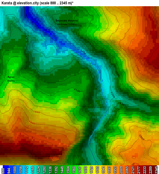
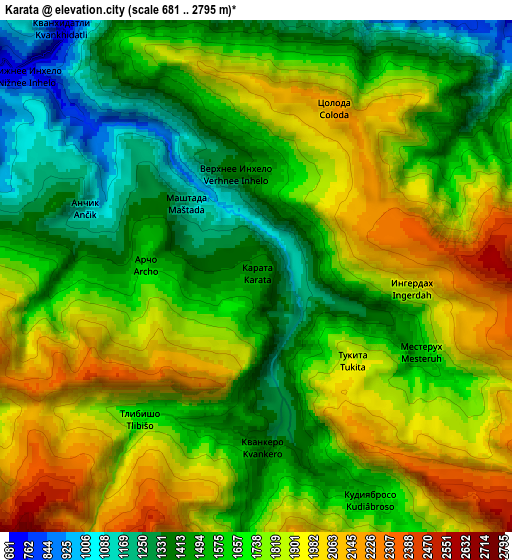
Below is the Elevation map of Karata, which displays elevation range with different colors. Scale of the first map is from 888 to 2345 m (2913 to 7694 ft) with average elevation of 1603 meters (=5259 ft) [note 1]
These maps also provides idea of topography and contour of this city, they are displayed at different zoom levels. More info about maps, scale and edge coordinates you can find below images.
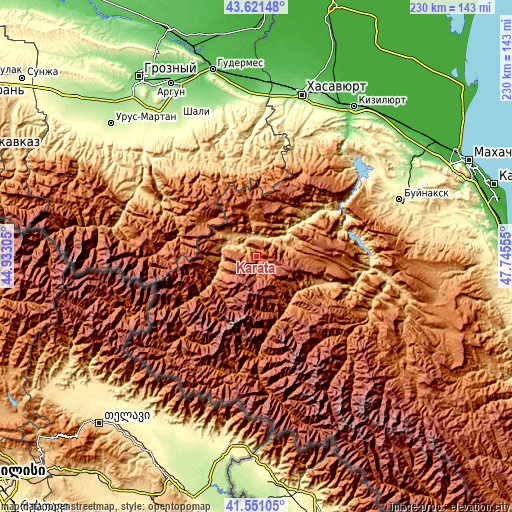
| \ | Map #1 | Map #2 | Topo.Map |
| Scale [m] | 888..2345 m | 681..2795 m | × |
| Scale [ft] | 2913..7694 ft | 2234..9170 ft | × |
| Average | 1603 m = 5259 ft | 1697.8 m = 5570 ft | × |
| Width | 7.19 km = 4.5 mi | 14.39 km = 8.9 mi | 230.2 km = 143 mi |
| Height | 7.19 km = 4.5 mi | 14.39 km = 8.9 mi | 230.2 km = 143 mi |
| ↑Max Latitude | 42.627202° | 42.659528° | 43.62148° |
| Latitude at center | 42.59486° | 42.59486° | 42.59486° |
| ↓Min Latitude | 42.562501° | 42.530125° | 41.55105° |
| ← Min Longitude | 46.295355° | 46.251409° | 44.93305° |
| Longitude center | 46.3393° | 46.3393° | 46.3393° |
| →Max Longitude | 46.383245° | 46.427191° | 47.74555° |
Nearby cities:
Cities around Karata sort by population:
• Shamil’kala elevation 589 m
44.1 km,  76°
76°
• Untsukul’ 874 m
38.8 km,  70°
70°
• Ansalta 1145 m
20.9 km,  300°
300°
• Andi 1551 m
21.9 km,  343°
343°
• Aknada 1733 m
25.5 km,  212°
212°
• Khunzakh 1661 m
30.7 km,  100°
100°
• Gimry 495 m
44.8 km, 65°
• Gagatli 1748 m
23.3 km,  350°
350°
• Siukh 1901 m
16.8 km,  88°
88°
• Khebda 904 m
24.2 km,  133°
133°
• Agvali 975 m
19 km,  250°
250°
• Ashil’ta 617 m
37.4 km,  58°
58°
Multilingual:
 En español:
Karata elevación 1457 m.
 En France:
Karata élévation 1457 m.


Sources and notes:
- [note 1] Map square and city borders are not equal. Map elevation data is calculated only from area inside that square.
- [src 1] Elevation data from geonames database provided with same terms of usage.
- [src 2] The elevation map of Karata is generated using elevation data from NASA's 3 arcsec (90m) resolution SRTM data.
- [src 3] Base (background) map © OpenStreetMap contributors tiles are generated by Geofabrik and OpenTopoMap.
Copyright & License:
This Karata Elevation Map is licensed under CC BY-SA. You may reuse any part from this page, if you give a proper credit by linking to this URL:
 More info on terms of use page.