Kashirskoye elevation
Kashirskoye (Voronezj), Russia elevation is 131 meters and Kashirskoye elevation in feet is 430 ft above sea level [src 1]. Kashirskoye is a populated place (feature code) with elevation that is 68 meters (223 ft) smaller than average city elevation in Russia.
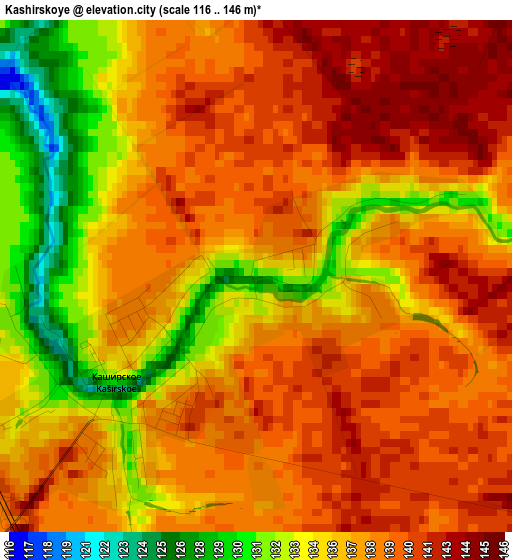
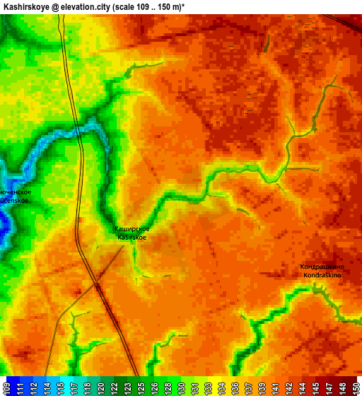
Below is the Elevation map of Kashirskoye, which displays elevation range with different colors. Scale of the first map is from 116 to 146 m (381 to 479 ft) with average elevation of 137.2 meters (=450 ft) [note 1]
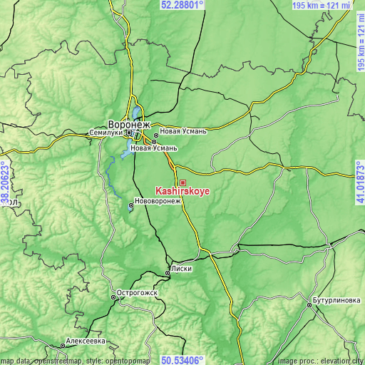
These maps also provides idea of topography and contour of this city, they are displayed at different zoom levels. More info about maps, scale and edge coordinates you can find below images.
| \ | Map #1 | Map #2 | Topo.Map |
| Scale [m] | 116..146 m | 109..150 m | × |
| Scale [ft] | 381..479 ft | 358..492 ft | × |
| Average | 137.2 m = 450 ft | 137.4 m = 451 ft | × |
| Width | 6.09 km = 3.8 mi | 12.19 km = 7.6 mi | 195 km = 121.2 mi |
| Height | 6.09 km = 3.8 mi | 12.19 km = 7.6 mi | 195 km = 121.2 mi |
| ↑Max Latitude | 51.446847° | 51.474227° | 52.28801° |
| Latitude at center | 51.41945° | 51.41945° | 51.41945° |
| ↓Min Latitude | 51.392037° | 51.364607° | 50.53406° |
| ← Min Longitude | 39.568535° | 39.524589° | 38.20623° |
| Longitude center | 39.61248° | 39.61248° | 39.61248° |
| →Max Longitude | 39.656425° | 39.700371° | 41.01873° |
Nearby cities:
Cities around Kashirskoye sort by population:
• Novovoronezh elevation 116 m
30.1 km,  245°
245°
• Novaya Usman’ 103 m
28.5 km,  330°
330°
• Somovo 110 m
39.6 km, 334°
• Volya 145 m
38.8 km,  352°
352°
• Maslovka 110 m
30 km,  299°
299°
• Shilovo 90 m
38.9 km,  291°
291°
• Kolodeznyy 80 m
31.3 km, 252°
• Davydovka 97 m
31.8 km,  203°
203°
• Orlovo 130 m
37.2 km,  357°
357°
• Sredniy Ikorets 87 m
40.4 km,  165°
165°
• Drakino 92 m
34.4 km,  205°
205°
• Podkletnoye 109 m
21.6 km, 331°
Multilingual:
 En español:
Kashirskoye elevación 131 m.
 En France:
Kashirskoye élévation 131 m.
 Auf Deutsch:
Kashirskoye höhe über dem Meeresspiegel ist 131 m.

Sources and notes:
- [note 1] Map square and city borders are not equal. Map elevation data is calculated only from area inside that square.
- [src 1] Elevation data from geonames database provided with same terms of usage.
- [src 2] The elevation map of Kashirskoye is generated using elevation data from NASA's 3 arcsec (90m) resolution SRTM data.
- [src 3] Base (background) map © OpenStreetMap contributors tiles are generated by Geofabrik and OpenTopoMap.
Copyright & License:
This Kashirskoye Elevation Map is licensed under CC BY-SA. You may reuse any part from this page, if you give a proper credit by linking to this URL:
 More info on terms of use page.