Khadyzhensk elevation
Khadyzhensk (Krasnodarskiy), Russia elevation is 113 meters and Khadyzhensk elevation in feet is 371 ft above sea level [src 1]. Khadyzhensk is a populated place (feature code) with elevation that is 86 meters (282 ft) smaller than average city elevation in Russia.
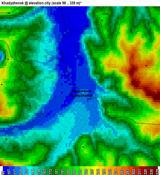
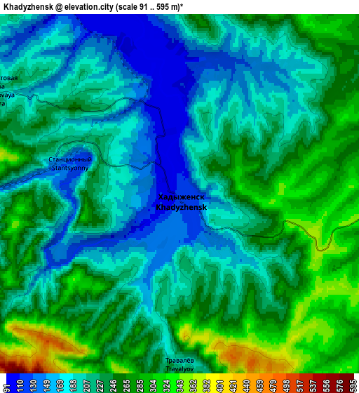
Below is the Elevation map of Khadyzhensk, which displays elevation range with different colors. Scale of the first map is from 98 to 339 m (322 to 1112 ft) with average elevation of 174.5 meters (=573 ft) [note 1]
These maps also provides idea of topography and contour of this city, they are displayed at different zoom levels. More info about maps, scale and edge coordinates you can find below images.
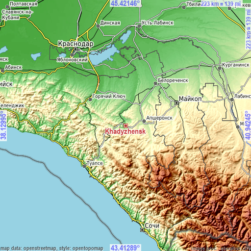
| \ | Map #1 | Map #2 | Topo.Map |
| Scale [m] | 98..339 m | 91..595 m | × |
| Scale [ft] | 322..1112 ft | 299..1952 ft | × |
| Average | 174.5 m = 573 ft | 223.7 m = 734 ft | × |
| Width | 6.98 km = 4.3 mi | 13.96 km = 8.7 mi | 223.3 km = 138.8 mi |
| Height | 6.98 km = 4.3 mi | 13.96 km = 8.7 mi | 223.3 km = 138.8 mi |
| ↑Max Latitude | 44.457175° | 44.488534° | 45.42146° |
| Latitude at center | 44.4258° | 44.4258° | 44.4258° |
| ↓Min Latitude | 44.394408° | 44.362999° | 43.41289° |
| ← Min Longitude | 39.492255° | 39.448309° | 38.12995° |
| Longitude center | 39.5362° | 39.5362° | 39.5362° |
| →Max Longitude | 39.580145° | 39.624091° | 40.94245° |
Nearby cities:
Cities around Khadyzhensk sort by population:
• Maykop elevation 227 m
49.5 km,  65°
65°
• Tuapse 52 m
50.9 km,  225°
225°
• Belorechensk 118 m
47 km,  35°
35°
• Apsheronsk 198 m
16.3 km, 74°
• Goryachiy Klyuch 58 m
39.5 km,  305°
305°
• Khanskaya 160 m
43.8 km,  50°
50°
• Saratovskaya 47 m
40 km,  321°
321°
• Pshekhskaya 137 m
36.4 km,  34°
34°
• Neftegorsk 333 m
15.2 km,  116°
116°
• Nebug 11 m
51 km,  236°
236°
• Yuzhnyy 139 m
42.6 km, 39°
• Agoy 18 m
50.4 km, 231°
Multilingual:
 En español:
Jadyzhensk elevación 113 m.
 En France:
Khadyjensk élévation 113 m.
 Auf Deutsch:
Chadyschensk höhe über dem Meeresspiegel ist 113 m.

Sources and notes:
- [note 1] Map square and city borders are not equal. Map elevation data is calculated only from area inside that square.
- [src 1] Elevation data from geonames database provided with same terms of usage.
- [src 2] The elevation map of Khadyzhensk is generated using elevation data from NASA's 3 arcsec (90m) resolution SRTM data.
- [src 3] Base (background) map © OpenStreetMap contributors tiles are generated by Geofabrik and OpenTopoMap.
Copyright & License:
This Khadyzhensk Elevation Map is licensed under CC BY-SA. You may reuse any part from this page, if you give a proper credit by linking to this URL:
 More info on terms of use page.