Khatukay elevation
Khatukay (Adygeya Republic), Russia elevation is 32 meters and Khatukay elevation in feet is 105 ft above sea level [src 1]. Khatukay is a populated place (feature code) with elevation that is 167 meters (548 ft) smaller than average city elevation in Russia.
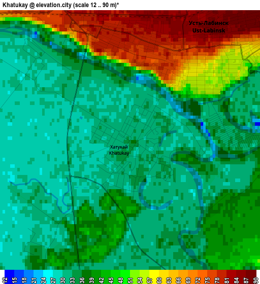
Below is the Elevation map of Khatukay, which displays elevation range with different colors. Scale of the first map is from 12 to 90 m (39 to 295 ft) with average elevation of 40.3 meters (=132 ft) [note 1]
These maps also provides idea of topography and contour of this city, they are displayed at different zoom levels. More info about maps, scale and edge coordinates you can find below images.
| \ | Map #1 | Map #2 | Topo.Map |
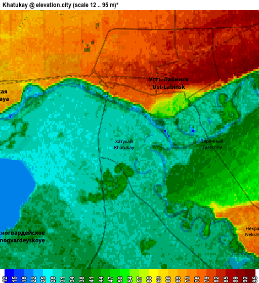
| Scale [m] | 12..90 m | 12..95 m | × |
| Scale [ft] | 39..295 ft | 39..312 ft | × |
| Average | 40.3 m = 132 ft | 48.6 m = 159 ft | × |
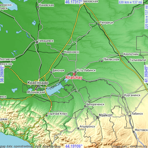
| Width | 6.89 km = 4.3 mi | 13.77 km = 8.6 mi | 220.4 km = 136.9 mi |
| Height | 6.89 km = 4.3 mi | 13.77 km = 8.6 mi | 220.4 km = 136.9 mi |
| ↑Max Latitude | 45.221702° | 45.252647° | 46.17317° |
| Latitude at center | 45.19074° | 45.19074° | 45.19074° |
| ↓Min Latitude | 45.159761° | 45.128765° | 44.19106° |
| ← Min Longitude | 39.619255° | 39.575309° | 38.25695° |
| Longitude center | 39.6632° | 39.6632° | 39.6632° |
| →Max Longitude | 39.707145° | 39.751091° | 41.06945° |
Nearby cities:
Cities around Khatukay sort by population:
• Ust’-Labinsk elevation 75 m
3 km,  42°
42°
• Ladozhskaya 94 m
25.2 km,  58°
58°
• Vasyurinskaya 43 m
20.4 km,  246°
246°
• Platnirovskaya 34 m
31.5 km,  316°
316°
• Starokorsunskaya 38 m
31 km,  241°
241°
• Dvubratskiy 101 m
12.3 km, 64°
• Krasnogvardeyskoye 33 m
10 km,  225°
225°
• Velikovechnoye 70 m
29.4 km,  165°
165°
• Ryazanskaya 65 m
26.8 km,  192°
192°
• Nekrasovskaya 75 m
8.4 km,  127°
127°
• Novolabinskaya 86 m
20.2 km,  116°
116°
• Beloye 45 m
15.9 km,  183°
183°
Multilingual:
 En español:
Khatukay elevación 32 m.
 En France:
Khatukay élévation 32 m.


Sources and notes:
- [note 1] Map square and city borders are not equal. Map elevation data is calculated only from area inside that square.
- [src 1] Elevation data from geonames database provided with same terms of usage.
- [src 2] The elevation map of Khatukay is generated using elevation data from NASA's 3 arcsec (90m) resolution SRTM data.
- [src 3] Base (background) map © OpenStreetMap contributors tiles are generated by Geofabrik and OpenTopoMap.
Copyright & License:
This Khatukay Elevation Map is licensed under CC BY-SA. You may reuse any part from this page, if you give a proper credit by linking to this URL:
 More info on terms of use page.