Kiknur elevation
Kiknur (Kirov), Russia elevation is 113 meters and Kiknur elevation in feet is 371 ft above sea level [src 1]. Kiknur is a populated place (feature code) with elevation that is 86 meters (282 ft) smaller than average city elevation in Russia.
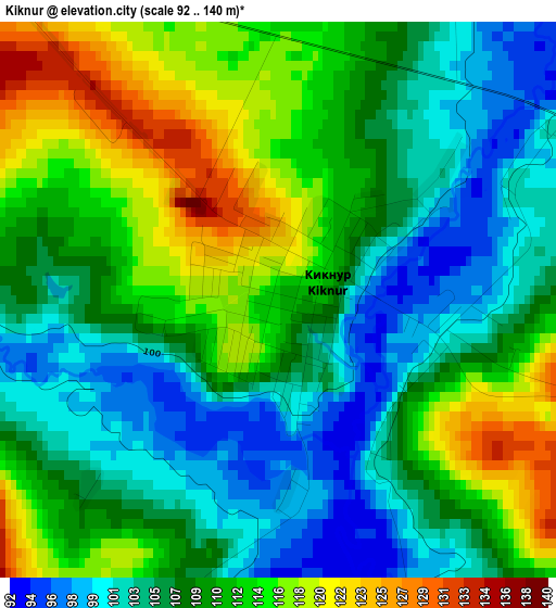
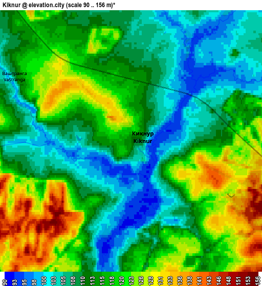
Below is the Elevation map of Kiknur, which displays elevation range with different colors. Scale of the first map is from 92 to 140 m (302 to 459 ft) with average elevation of 109 meters (=358 ft) [note 1]
These maps also provides idea of topography and contour of this city, they are displayed at different zoom levels. More info about maps, scale and edge coordinates you can find below images.
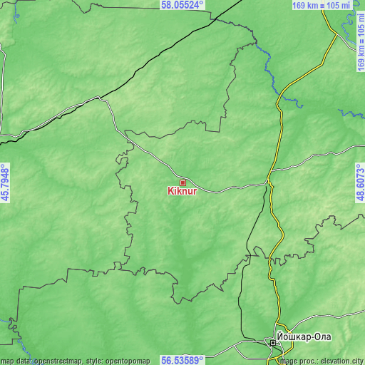
| \ | Map #1 | Map #2 | Topo.Map |
| Scale [m] | 92..140 m | 90..156 m | × |
| Scale [ft] | 302..459 ft | 295..512 ft | × |
| Average | 109 m = 358 ft | 114.6 m = 376 ft | × |
| Width | 5.28 km = 3.3 mi | 10.56 km = 6.6 mi | 168.9 km = 104.9 mi |
| Height | 5.28 km = 3.3 mi | 10.56 km = 6.6 mi | 168.9 km = 104.9 mi |
| ↑Max Latitude | 57.327141° | 57.350857° | 58.05524° |
| Latitude at center | 57.30341° | 57.30341° | 57.30341° |
| ↓Min Latitude | 57.279664° | 57.255902° | 56.53589° |
| ← Min Longitude | 47.157105° | 47.113159° | 45.7948° |
| Longitude center | 47.20105° | 47.20105° | 47.20105° |
| →Max Longitude | 47.244995° | 47.288941° | 48.6073° |
Nearby cities:
Cities around Kiknur sort by population:
• Shakhun’ya elevation 152 m
54.4 km,  319°
319°
• Yaransk 122 m
41.1 km,  90°
90°
• Orshanka 114 m
60 km,  135°
135°
• Sharanga 149 m
42.2 km,  250°
250°
• Sanchursk 86 m
40.4 km,  175°
175°
• Tonkino 120 m
45 km,  279°
279°
• Tuzha 110 m
55.4 km,  52°
52°
• Ar’ya 115 m
76.8 km,  285°
285°
• Tonshayevo 139 m
49.4 km,  346°
346°
• Pizhma 130 m
62.6 km,  355°
355°
• Kilemary 104 m
61.8 km,  199°
199°
• Prudy 147 m
63.2 km,  298°
298°
Multilingual:
 En español:
Kiknur elevación 113 m.
 En France:
Kiknur élévation 113 m.


Sources and notes:
- [note 1] Map square and city borders are not equal. Map elevation data is calculated only from area inside that square.
- [src 1] Elevation data from geonames database provided with same terms of usage.
- [src 2] The elevation map of Kiknur is generated using elevation data from NASA's 3 arcsec (90m) resolution SRTM data.
- [src 3] Base (background) map © OpenStreetMap contributors tiles are generated by Geofabrik and OpenTopoMap.
Copyright & License:
This Kiknur Elevation Map is licensed under CC BY-SA. You may reuse any part from this page, if you give a proper credit by linking to this URL:
 More info on terms of use page.