Kirillov elevation
Kirillov (Vologda, Kirillovskiy Rayon), Russia elevation is 126 meters and Kirillov elevation in feet is 413 ft above sea level [src 1]. Kirillov is a seat of a second-order administrative division (feature code) with elevation that is 73 meters (240 ft) smaller than average city elevation in Russia.
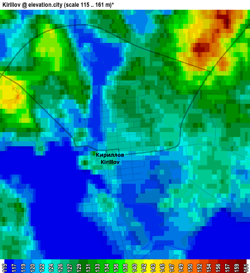
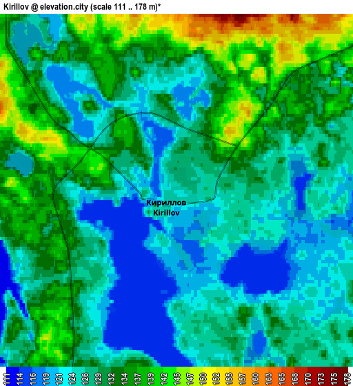
Below is the Elevation map of Kirillov, which displays elevation range with different colors. Scale of the first map is from 115 to 161 m (377 to 528 ft) with average elevation of 125 meters (=410 ft) [note 1]
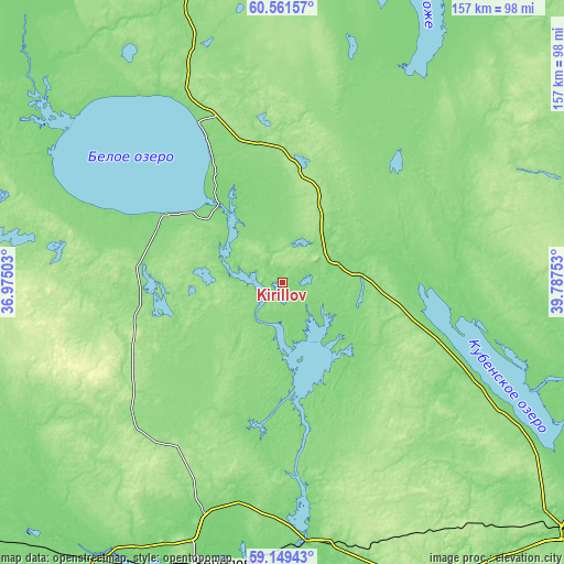
These maps also provides idea of topography and contour of this city, they are displayed at different zoom levels. More info about maps, scale and edge coordinates you can find below images.
| \ | Map #1 | Map #2 | Topo.Map |
| Scale [m] | 115..161 m | 111..178 m | × |
| Scale [ft] | 377..528 ft | 364..584 ft | × |
| Average | 125 m = 410 ft | 129.3 m = 424 ft | × |
| Width | 4.91 km = 3.1 mi | 9.81 km = 6.1 mi | 157 km = 97.6 mi |
| Height | 4.91 km = 3.1 mi | 9.81 km = 6.1 mi | 157 km = 97.6 mi |
| ↑Max Latitude | 59.885046° | 59.907088° | 60.56157° |
| Latitude at center | 59.86299° | 59.86299° | 59.86299° |
| ↓Min Latitude | 59.840919° | 59.818834° | 59.14943° |
| ← Min Longitude | 38.337335° | 38.293389° | 36.97503° |
| Longitude center | 38.38128° | 38.38128° | 38.38128° |
| →Max Longitude | 38.425225° | 38.469171° | 39.78753° |
Nearby cities:
Cities around Kirillov sort by population:
• Cherepovets elevation 136 m
85.6 km,  198°
198°
• Sheksna 109 m
73 km,  174°
174°
• Belozërsk 131 m
36.8 km,  300°
300°
• Suda 110 m
91.6 km,  210°
210°
• Tonshalovo 125 m
78.2 km, 198°
• Ust’ye 120 m
80.2 km,  108°
108°
• Ferapontovo 133 m
14.5 km,  45°
45°
• Lipin Bor 133 m
49.8 km,  333°
333°
• Nelazskoye 134 m
85.8 km, 209°
• Chebsara 174 m
78 km,  160°
160°
• Kuzino 127 m
10.4 km, 202°
• Goritsy 124 m
6.8 km,  276°
276°
Multilingual:
 En español:
Kirillov elevación 126 m.
 En France:
Kirillov élévation 126 m.
 Auf Deutsch:
Kirillov höhe über dem Meeresspiegel ist 126 m.

Sources and notes:
- [note 1] Map square and city borders are not equal. Map elevation data is calculated only from area inside that square.
- [src 1] Elevation data from geonames database provided with same terms of usage.
- [src 2] The elevation map of Kirillov is generated using elevation data from NASA's 3 arcsec (90m) resolution SRTM data.
- [src 3] Base (background) map © OpenStreetMap contributors tiles are generated by Geofabrik and OpenTopoMap.
Copyright & License:
This Kirillov Elevation Map is licensed under CC BY-SA. You may reuse any part from this page, if you give a proper credit by linking to this URL:
 More info on terms of use page.