Kirishi elevation
Kirishi (Leningradskaya Oblast'), Russia elevation is 33 meters and Kirishi elevation in feet is 108 ft above sea level [src 1]. Kirishi is a populated place (feature code) with elevation that is 166 meters (545 ft) smaller than average city elevation in Russia.
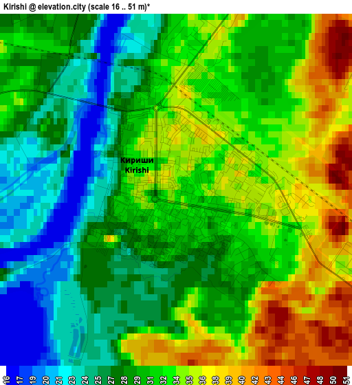
Below is the Elevation map of Kirishi, which displays elevation range with different colors. Scale of the first map is from 16 to 51 m (52 to 167 ft) with average elevation of 30.8 meters (=101 ft) [note 1]
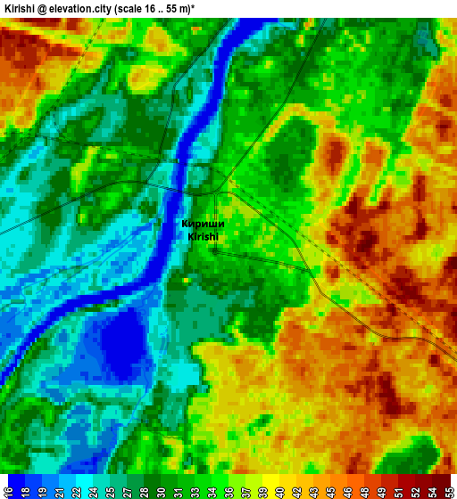
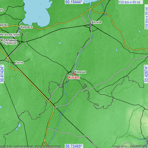
These maps also provides idea of topography and contour of this city, they are displayed at different zoom levels. More info about maps, scale and edge coordinates you can find below images.
| \ | Map #1 | Map #2 | Topo.Map |
| Scale [m] | 16..51 m | 16..55 m | × |
| Scale [ft] | 52..167 ft | 52..180 ft | × |
| Average | 30.8 m = 101 ft | 33.3 m = 109 ft | × |
| Width | 4.97 km = 3.1 mi | 9.94 km = 6.2 mi | 159 km = 98.8 mi |
| Height | 4.97 km = 3.1 mi | 9.94 km = 6.2 mi | 159 km = 98.8 mi |
| ↑Max Latitude | 59.469451° | 59.491768° | 60.15444° |
| Latitude at center | 59.44712° | 59.44712° | 59.44712° |
| ↓Min Latitude | 59.424774° | 59.402413° | 58.72469° |
| ← Min Longitude | 31.976545° | 31.932599° | 30.61424° |
| Longitude center | 32.02049° | 32.02049° | 32.02049° |
| →Max Longitude | 32.064435° | 32.108381° | 33.42674° |
Nearby cities:
Cities around Kirishi sort by population:
• Volkhov elevation 35 m
56.1 km,  18°
18°
• Tosno 41 m
65.3 km,  279°
279°
• Chudovo 32 m
41.4 km,  207°
207°
• Mga 30 m
63.4 km,  302°
302°
• Priladozhskiy 54 m
54 km,  326°
326°
• Lyuban’ 44 m
46.8 km,  256°
256°
• Kholm 60 m
51.1 km,  113°
113°
• Budogoshch’ 52 m
31.5 km,  125°
125°
• Ryabovo 51 m
50.5 km, 264°
• Nurma 59 m
57.8 km, 281°
• Staraya Ladoga 16 m
63.2 km,  14°
14°
• Krasnofarfornyy 24 m
35.9 km,  195°
195°
Multilingual:
 En español:
Kírishi elevación 33 m.
 En France:
Kirichi élévation 33 m.


Sources and notes:
- [note 1] Map square and city borders are not equal. Map elevation data is calculated only from area inside that square.
- [src 1] Elevation data from geonames database provided with same terms of usage.
- [src 2] The elevation map of Kirishi is generated using elevation data from NASA's 3 arcsec (90m) resolution SRTM data.
- [src 3] Base (background) map © OpenStreetMap contributors tiles are generated by Geofabrik and OpenTopoMap.
Copyright & License:
This Kirishi Elevation Map is licensed under CC BY-SA. You may reuse any part from this page, if you give a proper credit by linking to this URL:
 More info on terms of use page.