Konstantinovskoye elevation
Konstantinovskoye (Stavropol’ Kray), Russia elevation is 240 meters and Konstantinovskoye elevation in feet is 787 ft above sea level [src 1]. Konstantinovskoye is a populated place (feature code) with elevation that is 41 meters (135 ft) bigger than average city elevation in Russia.
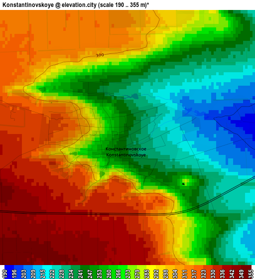
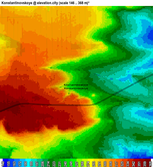
Below is the Elevation map of Konstantinovskoye, which displays elevation range with different colors. Scale of the first map is from 190 to 355 m (623 to 1165 ft) with average elevation of 280.6 meters (=921 ft) [note 1]
These maps also provides idea of topography and contour of this city, they are displayed at different zoom levels. More info about maps, scale and edge coordinates you can find below images.
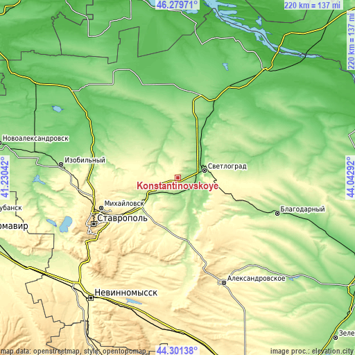
| \ | Map #1 | Map #2 | Topo.Map |
| Scale [m] | 190..355 m | 146..368 m | × |
| Scale [ft] | 623..1165 ft | 479..1207 ft | × |
| Average | 280.6 m = 921 ft | 266.9 m = 876 ft | × |
| Width | 6.87 km = 4.3 mi | 13.75 km = 8.5 mi | 220 km = 136.7 mi |
| Height | 6.87 km = 4.3 mi | 13.75 km = 8.5 mi | 220 km = 136.7 mi |
| ↑Max Latitude | 45.330073° | 45.360959° | 46.27971° |
| Latitude at center | 45.29917° | 45.29917° | 45.29917° |
| ↓Min Latitude | 45.26825° | 45.237314° | 44.30138° |
| ← Min Longitude | 42.592725° | 42.548779° | 41.23042° |
| Longitude center | 42.63667° | 42.63667° | 42.63667° |
| →Max Longitude | 42.680615° | 42.724561° | 44.04292° |
Nearby cities:
Cities around Konstantinovskoye sort by population:
• Mikhaylovsk elevation 425 m
51.5 km,  248°
248°
• Svetlograd 136 m
17.5 km,  76°
76°
• Ipatovo 101 m
51 km,  24°
24°
• Pelagiada 330 m
49.1 km,  257°
257°
• Trunovskoye 179 m
44.4 km,  298°
298°
• Gofitskoye 218 m
40.4 km,  127°
127°
• Blagodatnoye 212 m
11.8 km,  340°
340°
• Aleksandriya 174 m
52.8 km,  115°
115°
• Beshpagir 342 m
36.8 km,  213°
213°
• Sukhaya Buyvola 278 m
32.4 km, 119°
• Spitsevka 249 m
21.9 km, 206°
• Vysotskoye 347 m
37.1 km,  145°
145°
Multilingual:
 En español:
Konstantinovskoye elevación 240 m.
 En France:
Konstantinovskoye élévation 240 m.
 Auf Deutsch:
Konstantinovskoye höhe über dem Meeresspiegel ist 240 m.

Sources and notes:
- [note 1] Map square and city borders are not equal. Map elevation data is calculated only from area inside that square.
- [src 1] Elevation data from geonames database provided with same terms of usage.
- [src 2] The elevation map of Konstantinovskoye is generated using elevation data from NASA's 3 arcsec (90m) resolution SRTM data.
- [src 3] Base (background) map © OpenStreetMap contributors tiles are generated by Geofabrik and OpenTopoMap.
Copyright & License:
This Konstantinovskoye Elevation Map is licensed under CC BY-SA. You may reuse any part from this page, if you give a proper credit by linking to this URL:
 More info on terms of use page.