Krasnoye elevation
Krasnoye (Belgorod Oblast), Russia elevation is 209 meters and Krasnoye elevation in feet is 686 ft above sea level [src 1]. Krasnoye is a populated place (feature code) with elevation that is 10 meters (33 ft) bigger than average city elevation in Russia.
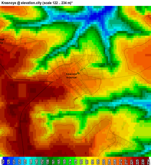
Below is the Elevation map of Krasnoye, which displays elevation range with different colors. Scale of the first map is from 122 to 234 m (400 to 768 ft) with average elevation of 191 meters (=627 ft) [note 1]
These maps also provides idea of topography and contour of this city, they are displayed at different zoom levels. More info about maps, scale and edge coordinates you can find below images.
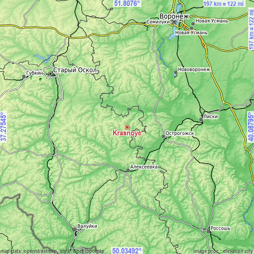
| \ | Map #1 | Topo.Map |
| Scale [m] | 122..234 m | × |
| Scale [ft] | 400..768 ft | × |
| Average | 191 m = 627 ft | × |
| Width | 6.16 km = 3.8 mi | 197.1 km = 122.5 mi |
| Height | 6.16 km = 3.8 mi | 197.1 km = 122.5 mi |
| ↑Max Latitude | 50.957389° | 51.8076° |
| Latitude at center | 50.9297° | 50.9297° |
| ↓Min Latitude | 50.901994° | 50.03492° |
| ← Min Longitude | 38.637755° | 37.27545° |
| Longitude center | 38.6817° | 38.6817° |
| →Max Longitude | 38.725645° | 40.08795° |
Nearby cities:
Cities around Krasnoye sort by population:
• Rossosh’ elevation 107 m
24.4 km,  330°
330°
• Alekseyevka 106 m
33.2 km,  178°
178°
• Novovoronezh 116 m
56.2 km,  41°
41°
• Ostrogozhsk 116 m
28.5 km,  104°
104°
• Krasnogvardeyskoye 120 m
36.8 km,  212°
212°
• Kolodeznyy 80 m
56.9 km, 37°
• Uryv-Pokrovka 92 m
39.6 km,  58°
58°
• Zasosna 112 m
38.8 km, 211°
• Ilovka 191 m
25.1 km,  187°
187°
• Drakino 92 m
55.5 km,  65°
65°
• Rogovatoye 206 m
39.4 km, 327°
• Korotoyak 93 m
35.2 km,  79°
79°
Multilingual:
 En español:
Krasnoye elevación 209 m.
 En France:
Krasnoye élévation 209 m.
 Auf Deutsch:
Krasnoye höhe über dem Meeresspiegel ist 209 m.

Sources and notes:
- [note 1] Map square and city borders are not equal. Map elevation data is calculated only from area inside that square.
- [src 1] Elevation data from geonames database provided with same terms of usage.
- [src 2] The elevation map of Krasnoye is generated using elevation data from NASA's 3 arcsec (90m) resolution SRTM data.
- [src 3] Base (background) map © OpenStreetMap contributors tiles are generated by Geofabrik and OpenTopoMap.
Copyright & License:
This Krasnoye Elevation Map is licensed under CC BY-SA. You may reuse any part from this page, if you give a proper credit by linking to this URL:
 More info on terms of use page.