Krylovskaya elevation
Krylovskaya (Krasnodarskiy), Russia elevation is 12 meters and Krylovskaya elevation in feet is 39 ft above sea level [src 1]. Krylovskaya is a populated place (feature code) with elevation that is 187 meters (614 ft) smaller than average city elevation in Russia.
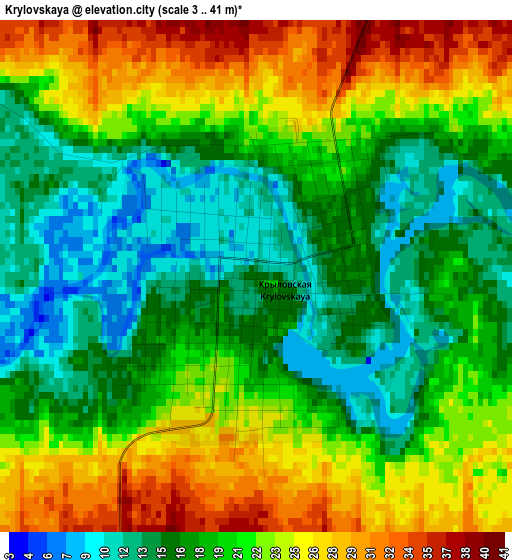
Below is the Elevation map of Krylovskaya, which displays elevation range with different colors. Scale of the first map is from 3 to 41 m (10 to 135 ft) with average elevation of 20.2 meters (=66 ft) [note 1]
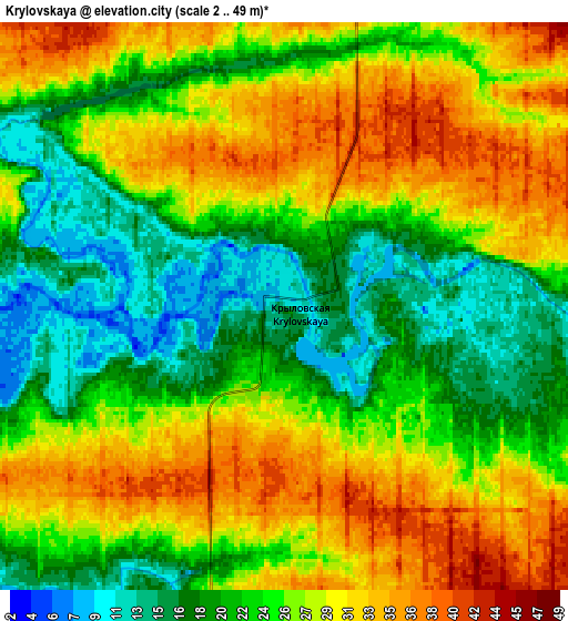
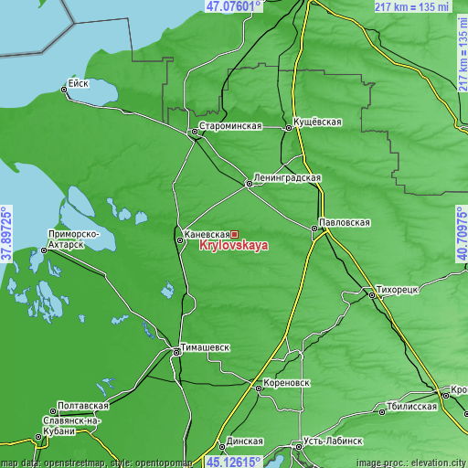
These maps also provides idea of topography and contour of this city, they are displayed at different zoom levels. More info about maps, scale and edge coordinates you can find below images.
| \ | Map #1 | Map #2 | Topo.Map |
| Scale [m] | 3..41 m | 2..49 m | × |
| Scale [ft] | 10..135 ft | 7..161 ft | × |
| Average | 20.2 m = 66 ft | 25.5 m = 84 ft | × |
| Width | 6.78 km = 4.2 mi | 13.55 km = 8.4 mi | 216.8 km = 134.7 mi |
| Height | 6.78 km = 4.2 mi | 13.55 km = 8.4 mi | 216.8 km = 134.7 mi |
| ↑Max Latitude | 46.140158° | 46.170599° | 47.07601° |
| Latitude at center | 46.1097° | 46.1097° | 46.1097° |
| ↓Min Latitude | 46.079225° | 46.048734° | 45.12615° |
| ← Min Longitude | 39.259555° | 39.215609° | 37.89725° |
| Longitude center | 39.3035° | 39.3035° | 39.3035° |
| →Max Longitude | 39.347445° | 39.391391° | 40.70975° |
Nearby cities:
Cities around Krylovskaya sort by population:
• Kanevskaya elevation 13 m
26.7 km,  264°
264°
• Leningradskaya 29 m
24.4 km,  15°
15°
• Pavlovskaya 44 m
37.1 km,  85°
85°
• Staroderevyankovskaya 22 m
26 km,  274°
274°
• Novominskaya 22 m
35.1 km,  310°
310°
• Pereyaslovskaya 21 m
36.9 km,  215°
215°
• Chelbasskaya 30 m
15.4 km,  160°
160°
• Staroleushkovskaya 33 m
37.8 km,  111°
111°
• Lenina 36 m
37.3 km,  97°
97°
• Novoplatnirovskaya 16 m
8.9 km, 92°
• Atamanskaya 31 m
26.7 km,  73°
73°
• Baturinskaya 15 m
35.6 km,  171°
171°
Multilingual:
 En español:
Krylovskaya elevación 12 m.
 En France:
Krylovskaya élévation 12 m.
 Auf Deutsch:
Krylovskaya höhe über dem Meeresspiegel ist 12 m.

Sources and notes:
- [note 1] Map square and city borders are not equal. Map elevation data is calculated only from area inside that square.
- [src 1] Elevation data from geonames database provided with same terms of usage.
- [src 2] The elevation map of Krylovskaya is generated using elevation data from NASA's 3 arcsec (90m) resolution SRTM data.
- [src 3] Base (background) map © OpenStreetMap contributors tiles are generated by Geofabrik and OpenTopoMap.
Copyright & License:
This Krylovskaya Elevation Map is licensed under CC BY-SA. You may reuse any part from this page, if you give a proper credit by linking to this URL:
 More info on terms of use page.