Krylovskaya elevation
Krylovskaya (Krasnodarskiy), Russia elevation is 28 meters and Krylovskaya elevation in feet is 92 ft above sea level [src 1]. Krylovskaya is a seat of a second-order administrative division (feature code) with elevation that is 171 meters (561 ft) smaller than average city elevation in Russia.
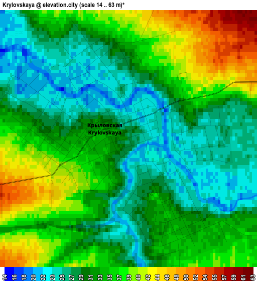
Below is the Elevation map of Krylovskaya, which displays elevation range with different colors. Scale of the first map is from 14 to 63 m (46 to 207 ft) with average elevation of 32.6 meters (=107 ft) [note 1]
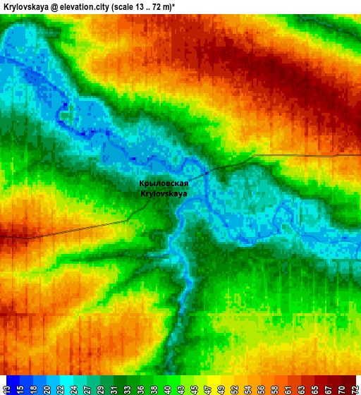
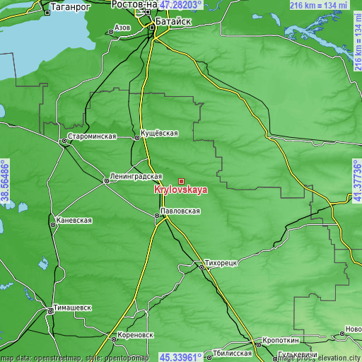
These maps also provides idea of topography and contour of this city, they are displayed at different zoom levels. More info about maps, scale and edge coordinates you can find below images.
| \ | Map #1 | Map #2 | Topo.Map |
| Scale [m] | 14..63 m | 13..72 m | × |
| Scale [ft] | 46..207 ft | 43..236 ft | × |
| Average | 32.6 m = 107 ft | 42.9 m = 141 ft | × |
| Width | 6.75 km = 4.2 mi | 13.5 km = 8.4 mi | 216 km = 134.2 mi |
| Height | 6.75 km = 4.2 mi | 13.5 km = 8.4 mi | 216 km = 134.2 mi |
| ↑Max Latitude | 46.349782° | 46.380107° | 47.28203° |
| Latitude at center | 46.31944° | 46.31944° | 46.31944° |
| ↓Min Latitude | 46.289081° | 46.258706° | 45.33961° |
| ← Min Longitude | 39.927165° | 39.883219° | 38.56486° |
| Longitude center | 39.97111° | 39.97111° | 39.97111° |
| →Max Longitude | 40.015055° | 40.059001° | 41.37736° |
Nearby cities:
Cities around Krylovskaya sort by population:
• Leningradskaya elevation 29 m
44.8 km,  270°
270°
• Pavlovskaya 44 m
24.8 km,  215°
215°
• Kushchëvskaya 13 m
37.3 km,  315°
315°
• Fastovetskaya 52 m
46.8 km,  161°
161°
• Novoleushkovskaya 42 m
36 km,  177°
177°
• Novorozhdestvenskaya 43 m
51 km, 181°
• Kalnibolotskaya 47 m
51.1 km,  132°
132°
• Staroleushkovskaya 33 m
40.4 km,  203°
203°
• Kislyakovskaya 17 m
26.5 km,  300°
300°
• Lenina 36 m
31.6 km,  207°
207°
• Novoplatnirovskaya 16 m
48.6 km,  240°
240°
• Atamanskaya 31 m
30.2 km, 238°
Multilingual:
 En español:
Krylovskaya elevación 28 m.
 En France:
Krylovskaya élévation 28 m.
 Auf Deutsch:
Krylovskaya höhe über dem Meeresspiegel ist 28 m.

Sources and notes:
- [note 1] Map square and city borders are not equal. Map elevation data is calculated only from area inside that square.
- [src 1] Elevation data from geonames database provided with same terms of usage.
- [src 2] The elevation map of Krylovskaya is generated using elevation data from NASA's 3 arcsec (90m) resolution SRTM data.
- [src 3] Base (background) map © OpenStreetMap contributors tiles are generated by Geofabrik and OpenTopoMap.
Copyright & License:
This Krylovskaya Elevation Map is licensed under CC BY-SA. You may reuse any part from this page, if you give a proper credit by linking to this URL:
 More info on terms of use page.