Kugesi elevation
Kugesi (Chuvashia), Russia elevation is 187 meters and Kugesi elevation in feet is 614 ft above sea level [src 1]. Kugesi is a populated place (feature code) with elevation that is 12 meters (39 ft) smaller than average city elevation in Russia.
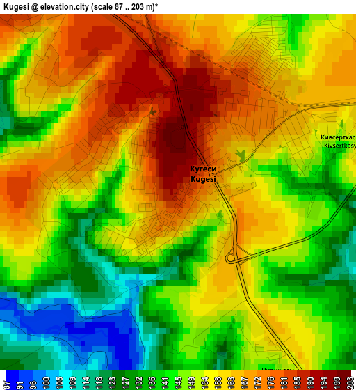
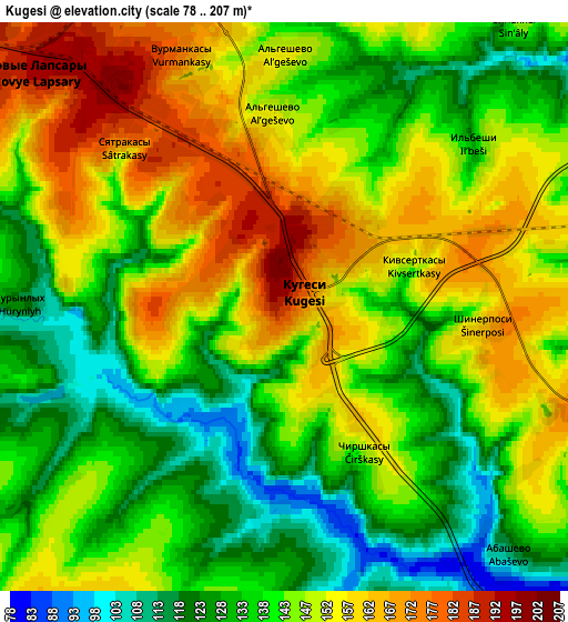
Below is the Elevation map of Kugesi, which displays elevation range with different colors. Scale of the first map is from 87 to 203 m (285 to 666 ft) with average elevation of 153.4 meters (=503 ft) [note 1]
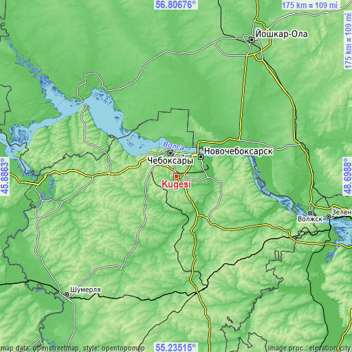
These maps also provides idea of topography and contour of this city, they are displayed at different zoom levels. More info about maps, scale and edge coordinates you can find below images.
| \ | Map #1 | Map #2 | Topo.Map |
| Scale [m] | 87..203 m | 78..207 m | × |
| Scale [ft] | 285..666 ft | 256..679 ft | × |
| Average | 153.4 m = 503 ft | 144.1 m = 473 ft | × |
| Width | 5.46 km = 3.4 mi | 10.92 km = 6.8 mi | 174.7 km = 108.6 mi |
| Height | 5.46 km = 3.4 mi | 10.92 km = 6.8 mi | 174.7 km = 108.6 mi |
| ↑Max Latitude | 56.053498° | 56.07803° | 56.80676° |
| Latitude at center | 56.02895° | 56.02895° | 56.02895° |
| ↓Min Latitude | 56.004387° | 55.979808° | 55.23515° |
| ← Min Longitude | 47.248605° | 47.204659° | 45.8863° |
| Longitude center | 47.29255° | 47.29255° | 47.29255° |
| →Max Longitude | 47.336495° | 47.380441° | 48.6988° |
Nearby cities:
Cities around Kugesi sort by population:
• Cheboksary elevation 106 m
11.8 km,  347°
347°
• Novocheboksarsk 105 m
14.7 km,  51°
51°
• Tsivil’sk 67 m
21.2 km,  146°
146°
• Zvenigovo 69 m
45.2 km,  97°
97°
• Mariinskiy Posad 85 m
28.1 km,  70°
70°
• Novyye Lapsary 193 m
6.6 km,  312°
312°
• Krasnoarmeyskoye 109 m
30 km,  194°
194°
• Atlashevo 72 m
16.5 km, 96°
• Yantikovo 97 m
44.9 km,  120°
120°
• Ishley 164 m
15.1 km,  267°
267°
• Morgaushi 154 m
33 km,  257°
257°
• Vilovatovo 187 m
45.7 km,  290°
290°
Multilingual:
 En español:
Kugesi elevación 187 m.
 En France:
Kugesi élévation 187 m.


Sources and notes:
- [note 1] Map square and city borders are not equal. Map elevation data is calculated only from area inside that square.
- [src 1] Elevation data from geonames database provided with same terms of usage.
- [src 2] The elevation map of Kugesi is generated using elevation data from NASA's 3 arcsec (90m) resolution SRTM data.
- [src 3] Base (background) map © OpenStreetMap contributors tiles are generated by Geofabrik and OpenTopoMap.
Copyright & License:
This Kugesi Elevation Map is licensed under CC BY-SA. You may reuse any part from this page, if you give a proper credit by linking to this URL:
 More info on terms of use page.