Kulary elevation
Kulary (Chechnya), Russia elevation is 165 meters and Kulary elevation in feet is 541 ft above sea level [src 1]. Kulary is a populated place (feature code) with elevation that is 34 meters (112 ft) smaller than average city elevation in Russia.
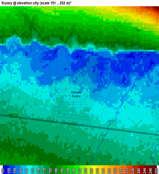
Below is the Elevation map of Kulary, which displays elevation range with different colors. Scale of the first map is from 151 to 252 m (495 to 827 ft) with average elevation of 176.2 meters (=578 ft) [note 1]
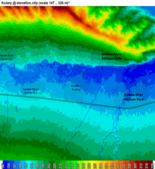
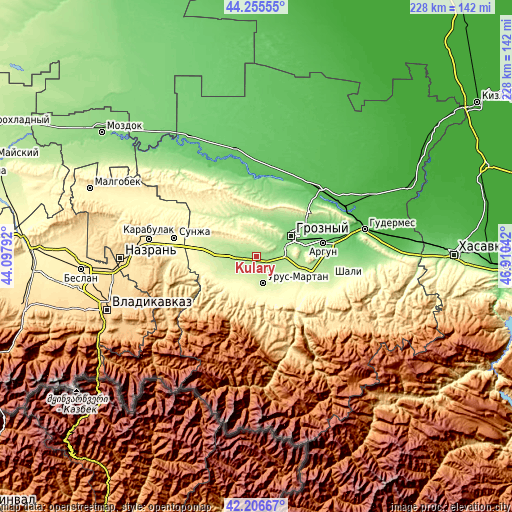
These maps also provides idea of topography and contour of this city, they are displayed at different zoom levels. More info about maps, scale and edge coordinates you can find below images.
| \ | Map #1 | Map #2 | Topo.Map |
| Scale [m] | 151..252 m | 147..326 m | × |
| Scale [ft] | 495..827 ft | 482..1070 ft | × |
| Average | 176.2 m = 578 ft | 196.7 m = 645 ft | × |
| Width | 7.12 km = 4.4 mi | 14.24 km = 8.8 mi | 227.8 km = 141.5 mi |
| Height | 7.12 km = 4.4 mi | 14.24 km = 8.8 mi | 227.8 km = 141.5 mi |
| ↑Max Latitude | 43.271725° | 43.303714° | 44.25555° |
| Latitude at center | 43.23972° | 43.23972° | 43.23972° |
| ↓Min Latitude | 43.207698° | 43.175659° | 42.20667° |
| ← Min Longitude | 45.460225° | 45.416279° | 44.09792° |
| Longitude center | 45.50417° | 45.50417° | 45.50417° |
| →Max Longitude | 45.548115° | 45.592061° | 46.91042° |
Nearby cities:
Cities around Kulary sort by population:
• Groznyy elevation 128 m
17 km,  61°
61°
• Urus-Martan 236 m
12.4 km,  167°
167°
• Goyty 213 m
12.8 km,  131°
131°
• Alkhan-Kala 196 m
3.5 km,  53°
53°
• Gekhi 227 m
8.9 km,  196°
196°
• Katyr-Yurt 237 m
13.3 km,  235°
235°
• Alkhan-Yurt 165 m
5.6 km,  99°
99°
• Valerik 220 m
10.3 km,  229°
229°
• Zakan-Yurt 187 m
7 km,  290°
290°
• Roshni-Chu 354 m
17.2 km,  193°
193°
• Shaami-Yurt 184 m
9.5 km,  261°
261°
• Khambi-Irze 173 m
4.2 km, 262°
Multilingual:
 En español:
Kulary elevación 165 m.
 En France:
Kulary élévation 165 m.


Sources and notes:
- [note 1] Map square and city borders are not equal. Map elevation data is calculated only from area inside that square.
- [src 1] Elevation data from geonames database provided with same terms of usage.
- [src 2] The elevation map of Kulary is generated using elevation data from NASA's 3 arcsec (90m) resolution SRTM data.
- [src 3] Base (background) map © OpenStreetMap contributors tiles are generated by Geofabrik and OpenTopoMap.
Copyright & License:
This Kulary Elevation Map is licensed under CC BY-SA. You may reuse any part from this page, if you give a proper credit by linking to this URL:
 More info on terms of use page.