Kuznetsk elevation
Kuznetsk (Penza), Russia elevation is 239 meters and Kuznetsk elevation in feet is 784 ft above sea level [src 1]. Kuznetsk is a populated place (feature code) with elevation that is 40 meters (131 ft) bigger than average city elevation in Russia.
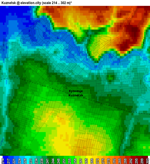
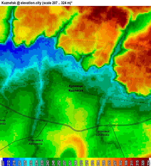
Below is the Elevation map of Kuznetsk, which displays elevation range with different colors. Scale of the first map is from 214 to 302 m (702 to 991 ft) with average elevation of 248.4 meters (=815 ft) [note 1]
These maps also provides idea of topography and contour of this city, they are displayed at different zoom levels. More info about maps, scale and edge coordinates you can find below images.
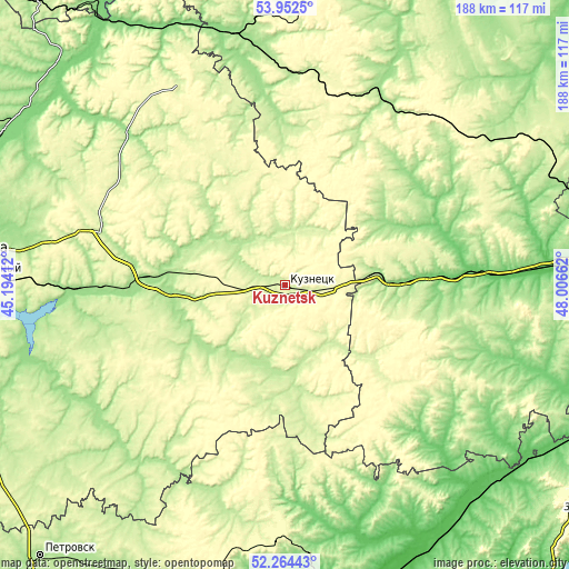
| \ | Map #1 | Map #2 | Topo.Map |
| Scale [m] | 214..302 m | 207..324 m | × |
| Scale [ft] | 702..991 ft | 679..1063 ft | × |
| Average | 248.4 m = 815 ft | 261.7 m = 859 ft | × |
| Width | 5.87 km = 3.6 mi | 11.73 km = 7.3 mi | 187.7 km = 116.6 mi |
| Height | 5.87 km = 3.6 mi | 11.73 km = 7.3 mi | 187.7 km = 116.6 mi |
| ↑Max Latitude | 53.143117° | 53.169468° | 53.9525° |
| Latitude at center | 53.11675° | 53.11675° | 53.11675° |
| ↓Min Latitude | 53.090367° | 53.063967° | 52.26443° |
| ← Min Longitude | 46.556425° | 46.512479° | 45.19412° |
| Longitude center | 46.60037° | 46.60037° | 46.60037° |
| →Max Longitude | 46.644315° | 46.688261° | 48.00662° |
Nearby cities:
Cities around Kuznetsk sort by population:
• Zarechnyy elevation 221 m
2.2 km,  328°
328°
• Srednyaya Yelyuzan’ 236 m
44.5 km,  256°
256°
• Sosnovoborsk 188 m
30.4 km,  309°
309°
• Chaadayevka 165 m
46 km,  273°
273°
• Nikolayevka 131 m
40.3 km,  88°
88°
• Pavlovka 257 m
54.4 km,  11°
11°
• Russkiy Kameshkir 215 m
44.6 km,  230°
230°
• Makhalino 223 m
25.6 km, 262°
• Neverkino 228 m
38 km,  165°
165°
• Inderka 193 m
27.1 km,  302°
302°
• Poselki 223 m
6.7 km,  284°
284°
• Imeni Vladimira Il’icha Lenina 209 m
55.8 km,  26°
26°
Multilingual:
 En español:
Kuznetsk elevación 239 m.
 En France:
Kouznetsk élévation 239 m.


Sources and notes:
- [note 1] Map square and city borders are not equal. Map elevation data is calculated only from area inside that square.
- [src 1] Elevation data from geonames database provided with same terms of usage.
- [src 2] The elevation map of Kuznetsk is generated using elevation data from NASA's 3 arcsec (90m) resolution SRTM data.
- [src 3] Base (background) map © OpenStreetMap contributors tiles are generated by Geofabrik and OpenTopoMap.
Copyright & License:
This Kuznetsk Elevation Map is licensed under CC BY-SA. You may reuse any part from this page, if you give a proper credit by linking to this URL:
 More info on terms of use page.