Yubileyny elevation
Yubileyny (Moscow Oblast), Russia elevation is 163 meters and Yubileyny elevation in feet is 535 ft above sea level [src 1]. Yubileyny is a populated place (feature code) with elevation that is 36 meters (118 ft) smaller than average city elevation in Russia.
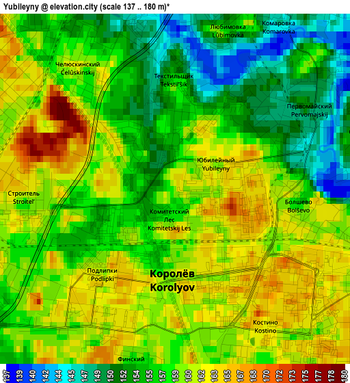
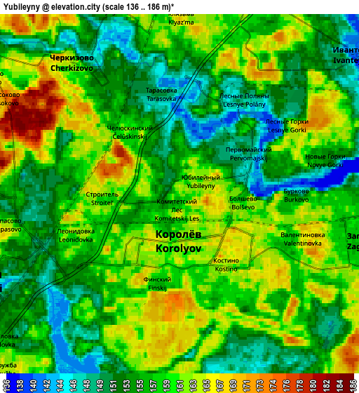
Below is the Elevation map of Yubileyny, which displays elevation range with different colors. Scale of the first map is from 137 to 180 m (449 to 591 ft) with average elevation of 157.9 meters (=518 ft) [note 1]
These maps also provides idea of topography and contour of this city, they are displayed at different zoom levels. More info about maps, scale and edge coordinates you can find below images.
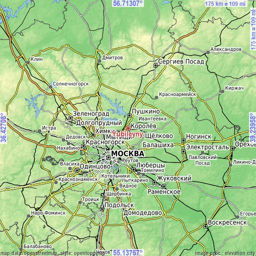
| \ | Map #1 | Map #2 | Topo.Map |
| Scale [m] | 137..180 m | 136..186 m | × |
| Scale [ft] | 449..591 ft | 446..610 ft | × |
| Average | 157.9 m = 518 ft | 157.7 m = 517 ft | × |
| Width | 5.47 km = 3.4 mi | 10.95 km = 6.8 mi | 175.2 km = 108.9 mi |
| Height | 5.47 km = 3.4 mi | 10.95 km = 6.8 mi | 175.2 km = 108.9 mi |
| ↑Max Latitude | 55.957938° | 55.982531° | 56.71307° |
| Latitude at center | 55.93333° | 55.93333° | 55.93333° |
| ↓Min Latitude | 55.908706° | 55.884066° | 55.13757° |
| ← Min Longitude | 37.789385° | 37.745439° | 36.42708° |
| Longitude center | 37.83333° | 37.83333° | 37.83333° |
| →Max Longitude | 37.877275° | 37.921221° | 39.23958° |
Nearby cities:
Cities around Yubileyny sort by population:
• Mytishchi elevation 158 m
6.8 km,  249°
249°
• Korolev 161 m
2.2 km,  192°
192°
• Shchelkovo 145 m
8.7 km,  96°
96°
• Ivanteyevka 140 m
6.9 km,  52°
52°
• Bolshevo 159 m
0.3 km,  309°
309°
• Mamontovka 160 m
5.3 km,  350°
350°
• Zagoryanskiy 143 m
7.8 km,  90°
90°
• Pirogovskiy 152 m
8 km, 308°
• Druzhba 163 m
7.7 km,  227°
227°
• Lesnyye Polyany 168 m
4.2 km,  29°
29°
• Cherkizovo 157 m
5.5 km,  328°
328°
• Tarasovka 148 m
2.7 km,  13°
13°
Multilingual:
 En español:
Yubileyny elevación 163 m.
 En France:
Ioubileïny élévation 163 m.
 Auf Deutsch:
Jubileiny höhe über dem Meeresspiegel ist 163 m.

Sources and notes:
- [note 1] Map square and city borders are not equal. Map elevation data is calculated only from area inside that square.
- [src 1] Elevation data from geonames database provided with same terms of usage.
- [src 2] The elevation map of Yubileyny is generated using elevation data from NASA's 3 arcsec (90m) resolution SRTM data.
- [src 3] Base (background) map © OpenStreetMap contributors tiles are generated by Geofabrik and OpenTopoMap.
Copyright & License:
This Yubileyny Elevation Map is licensed under CC BY-SA. You may reuse any part from this page, if you give a proper credit by linking to this URL:
 More info on terms of use page.