Lomintsevskiy elevation
Lomintsevskiy (Tula), Russia elevation is 177 meters and Lomintsevskiy elevation in feet is 581 ft above sea level [src 1]. Lomintsevskiy is a populated place (feature code) with elevation that is 22 meters (72 ft) smaller than average city elevation in Russia.
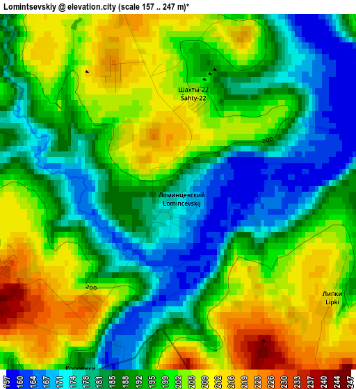
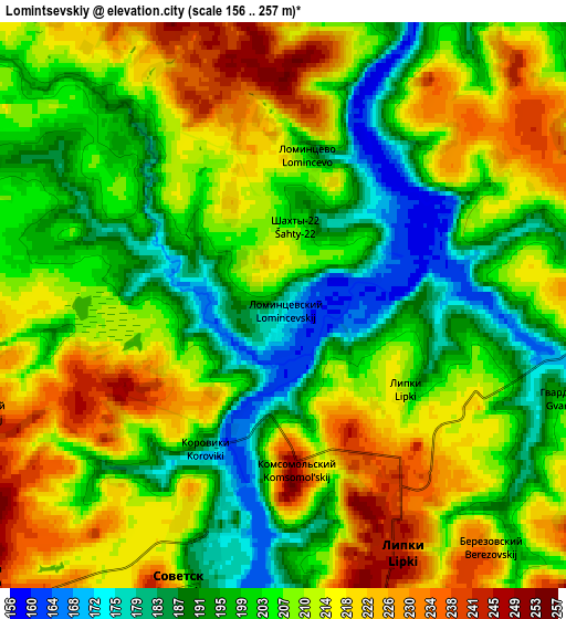
Below is the Elevation map of Lomintsevskiy, which displays elevation range with different colors. Scale of the first map is from 157 to 247 m (515 to 810 ft) with average elevation of 193.9 meters (=636 ft) [note 1]
These maps also provides idea of topography and contour of this city, they are displayed at different zoom levels. More info about maps, scale and edge coordinates you can find below images.
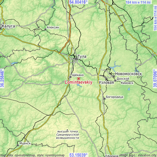
| \ | Map #1 | Map #2 | Topo.Map |
| Scale [m] | 157..247 m | 156..257 m | × |
| Scale [ft] | 515..810 ft | 512..843 ft | × |
| Average | 193.9 m = 636 ft | 206.5 m = 677 ft | × |
| Width | 5.75 km = 3.6 mi | 11.49 km = 7.1 mi | 183.9 km = 114.3 mi |
| Height | 5.75 km = 3.6 mi | 11.49 km = 7.1 mi | 183.9 km = 114.3 mi |
| ↑Max Latitude | 54.011311° | 54.037127° | 54.80416° |
| Latitude at center | 53.98548° | 53.98548° | 53.98548° |
| ↓Min Latitude | 53.959633° | 53.933769° | 53.15039° |
| ← Min Longitude | 37.620765° | 37.576819° | 36.25846° |
| Longitude center | 37.66471° | 37.66471° | 37.66471° |
| →Max Longitude | 37.708655° | 37.752601° | 39.07096° |
Nearby cities:
Cities around Lomintsevskiy sort by population:
• Tula elevation 161 m
23.6 km,  352°
352°
• Shchëkino 241 m
9.6 km,  283°
283°
• Kireyevsk 212 m
18.2 km,  108°
108°
• Kosaya Gora 233 m
16.8 km,  332°
332°
• Skuratovskiy 250 m
13.5 km,  342°
342°
• Pervomayskiy 239 m
12.1 km,  302°
302°
• Bolokhovo 237 m
15.3 km,  44°
44°
• Mendeleyevskiy 244 m
17.6 km, 343°
• Borodinskiy 200 m
10.1 km,  81°
81°
• Shvartsevskiy 229 m
24.3 km,  60°
60°
• Priupskiy 249 m
9.6 km,  151°
151°
• Brusyanka 195 m
24.3 km,  90°
90°
Multilingual:
 En español:
Lomintsevskiy elevación 177 m.
 En France:
Lomintsevskiy élévation 177 m.
 Auf Deutsch:
Lomintsevskiy höhe über dem Meeresspiegel ist 177 m.

Sources and notes:
- [note 1] Map square and city borders are not equal. Map elevation data is calculated only from area inside that square.
- [src 1] Elevation data from geonames database provided with same terms of usage.
- [src 2] The elevation map of Lomintsevskiy is generated using elevation data from NASA's 3 arcsec (90m) resolution SRTM data.
- [src 3] Base (background) map © OpenStreetMap contributors tiles are generated by Geofabrik and OpenTopoMap.
Copyright & License:
This Lomintsevskiy Elevation Map is licensed under CC BY-SA. You may reuse any part from this page, if you give a proper credit by linking to this URL:
 More info on terms of use page.