Loukhi elevation
Loukhi (Karelia), Russia elevation is 95 meters and Loukhi elevation in feet is 312 ft above sea level [src 1]. Loukhi is a populated place (feature code) with elevation that is 104 meters (341 ft) smaller than average city elevation in Russia.
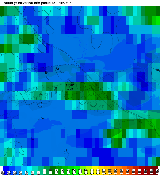
Below is the Elevation map of Loukhi, which displays elevation range with different colors. Scale of the first map is from 93 to 105 m (305 to 344 ft) with average elevation of 96 meters (=315 ft) [note 1]
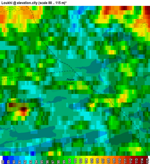
These maps also provides idea of topography and contour of this city, they are displayed at different zoom levels. More info about maps, scale and edge coordinates you can find below images.
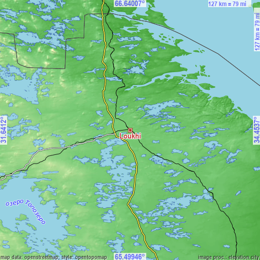
| \ | Map #1 | Map #2 | Topo.Map |
| Scale [m] | 93..105 m | 88..115 m | × |
| Scale [ft] | 305..344 ft | 289..377 ft | × |
| Average | 96 m = 315 ft | 97.4 m = 320 ft | × |
| Width | 3.96 km = 2.5 mi | 7.93 km = 4.9 mi | 126.8 km = 78.8 mi |
| Height | 3.96 km = 2.5 mi | 7.93 km = 4.9 mi | 126.8 km = 78.8 mi |
| ↑Max Latitude | 66.093975° | 66.111777° | 66.64007° |
| Latitude at center | 66.07616° | 66.07616° | 66.07616° |
| ↓Min Latitude | 66.058333° | 66.040493° | 65.49946° |
| ← Min Longitude | 33.003505° | 32.959559° | 31.6412° |
| Longitude center | 33.04745° | 33.04745° | 33.04745° |
| →Max Longitude | 33.091395° | 33.135341° | 34.4537° |
Nearby cities:
Cities around Loukhi sort by population:
• Kandalaksha elevation 40 m
123.9 km,  346°
346°
• Polyarnyye Zori 112 m
145.4 km, 350°
• Kem’ 15 m
143.2 km,  150°
150°
• Zelenoborskiy 72 m
90.7 km,  340°
340°
• Umba 1 m
89.1 km,  40°
40°
• Kalevala 106 m
129.5 km,  221°
221°
• Chupa 6 m
21.6 km,  0°
0°
• Poyakonda 4 m
58.5 km, 350°
• Rabocheostrovsk 1 m
144.8 km, 146°
• Pyaozerskiy 149 m
95.2 km,  248°
248°
• Afrikanda 138 m
152.4 km,  355°
355°
• Yushkozero 105 m
153.6 km,  196°
196°
Multilingual:
 En español:
Loukhi elevación 95 m.
 En France:
Loukhi élévation 95 m.


Sources and notes:
- [note 1] Map square and city borders are not equal. Map elevation data is calculated only from area inside that square.
- [src 1] Elevation data from geonames database provided with same terms of usage.
- [src 2] The elevation map of Loukhi is generated using GMTED2010 database with 7.5 arcsec (225m) resolution.
- [src 3] Base (background) map © OpenStreetMap contributors tiles are generated by Geofabrik and OpenTopoMap.
Copyright & License:
This Loukhi Elevation Map is licensed under CC BY-SA. You may reuse any part from this page, if you give a proper credit by linking to this URL:
 More info on terms of use page.