Lyubytino elevation
Lyubytino (Novgorod Oblast), Russia elevation is 71 meters and Lyubytino elevation in feet is 233 ft above sea level [src 1]. Lyubytino is a populated place (feature code) with elevation that is 128 meters (420 ft) smaller than average city elevation in Russia.
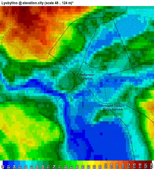
Below is the Elevation map of Lyubytino, which displays elevation range with different colors. Scale of the first map is from 48 to 124 m (157 to 407 ft) with average elevation of 73.6 meters (=241 ft) [note 1]
These maps also provides idea of topography and contour of this city, they are displayed at different zoom levels. More info about maps, scale and edge coordinates you can find below images.
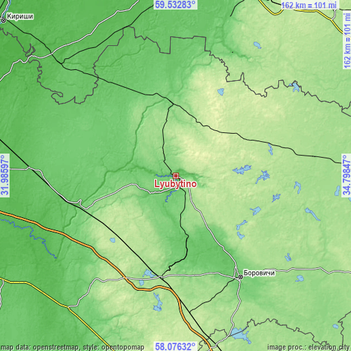
| \ | Map #1 | Topo.Map |
| Scale [m] | 48..124 m | × |
| Scale [ft] | 157..407 ft | × |
| Average | 73.6 m = 241 ft | × |
| Width | 5.06 km = 3.1 mi | 161.9 km = 100.6 mi |
| Height | 5.06 km = 3.1 mi | 161.9 km = 100.6 mi |
| ↑Max Latitude | 58.834969° | 59.53283° |
| Latitude at center | 58.81222° | 58.81222° |
| ↓Min Latitude | 58.789456° | 58.07632° |
| ← Min Longitude | 33.348275° | 31.98597° |
| Longitude center | 33.39222° | 33.39222° |
| →Max Longitude | 33.436165° | 34.79847° |
Nearby cities:
Cities around Lyubytino sort by population:
• Borovichi elevation 101 m
56.1 km,  147°
147°
• Okulovka 164 m
46.1 km,  187°
187°
• Malaya Vishera 68 m
67.4 km,  273°
273°
• Khvoynaya 164 m
66.3 km,  81°
81°
• Kholm 60 m
59.3 km,  328°
328°
• Budogoshch’ 52 m
74.2 km,  314°
314°
• Uglovka 193 m
64.1 km,  173°
173°
• Kulotino 104 m
40.3 km,  180°
180°
• Moshenskoye 153 m
77 km,  115°
115°
• Nebolchi 115 m
34.8 km,  355°
355°
• Opechenskiy Posad 130 m
73.1 km,  144°
144°
• Zarubino 134 m
9.8 km, 150°
Multilingual:
 En español:
Lyubytino elevación 71 m.
 En France:
Lyubytino élévation 71 m.
 Auf Deutsch:
Lyubytino höhe über dem Meeresspiegel ist 71 m.

Sources and notes:
- [note 1] Map square and city borders are not equal. Map elevation data is calculated only from area inside that square.
- [src 1] Elevation data from geonames database provided with same terms of usage.
- [src 2] The elevation map of Lyubytino is generated using elevation data from NASA's 3 arcsec (90m) resolution SRTM data.
- [src 3] Base (background) map © OpenStreetMap contributors tiles are generated by Geofabrik and OpenTopoMap.
Copyright & License:
This Lyubytino Elevation Map is licensed under CC BY-SA. You may reuse any part from this page, if you give a proper credit by linking to this URL:
 More info on terms of use page.