Milyutinskaya elevation
Milyutinskaya (Rostov), Russia elevation is 90 meters and Milyutinskaya elevation in feet is 295 ft above sea level [src 1]. Milyutinskaya is a seat of a second-order administrative division (feature code) with elevation that is 109 meters (358 ft) smaller than average city elevation in Russia.
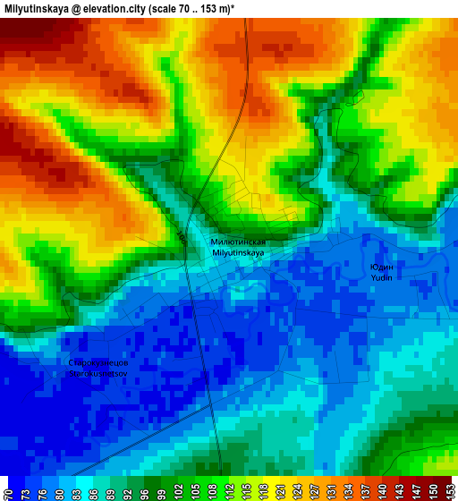
Below is the Elevation map of Milyutinskaya, which displays elevation range with different colors. Scale of the first map is from 70 to 153 m (230 to 502 ft) with average elevation of 100.8 meters (=331 ft) [note 1]
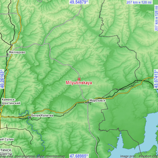
These maps also provides idea of topography and contour of this city, they are displayed at different zoom levels. More info about maps, scale and edge coordinates you can find below images.
| \ | Map #1 | Topo.Map |
| Scale [m] | 70..153 m | × |
| Scale [ft] | 230..502 ft | × |
| Average | 100.8 m = 331 ft | × |
| Width | 6.46 km = 4 mi | 206.7 km = 128.4 mi |
| Height | 6.46 km = 4 mi | 206.7 km = 128.4 mi |
| ↑Max Latitude | 48.656917° | 49.54879° |
| Latitude at center | 48.62788° | 48.62788° |
| ↓Min Latitude | 48.598826° | 47.68985° |
| ← Min Longitude | 41.623935° | 40.26163° |
| Longitude center | 41.66788° | 41.66788° |
| →Max Longitude | 41.711825° | 43.07413° |
Nearby cities:
Cities around Milyutinskaya sort by population:
• Morozovsk elevation 73 m
32.5 km,  158°
158°
• Tatsinskiy 82 m
56 km,  211°
211°
• Sholokhovskiy 153 m
59.9 km,  229°
229°
• Oblivskaya 59 m
62.2 km,  99°
99°
• Gornyatskiy 96 m
66.1 km,  236°
236°
• Kashary 81 m
66.7 km,  313°
313°
• Zhirnov 65 m
64.7 km,  218°
218°
• Chernyshkovskiy 76 m
47.4 km,  118°
118°
• Bokovskaya 94 m
67.9 km,  10°
10°
• Bystrogorskiy 42 m
60.7 km, 219°
• Uglegorskiy 110 m
52.6 km, 215°
• Sovetskaya 74 m
53.9 km,  38°
38°
Multilingual:
 En español:
Milyutinskaya elevación 90 m.
 En France:
Milyutinskaya élévation 90 m.
 Auf Deutsch:
Milyutinskaya höhe über dem Meeresspiegel ist 90 m.

Sources and notes:
- [note 1] Map square and city borders are not equal. Map elevation data is calculated only from area inside that square.
- [src 1] Elevation data from geonames database provided with same terms of usage.
- [src 2] The elevation map of Milyutinskaya is generated using elevation data from NASA's 3 arcsec (90m) resolution SRTM data.
- [src 3] Base (background) map © OpenStreetMap contributors tiles are generated by Geofabrik and OpenTopoMap.
Copyright & License:
This Milyutinskaya Elevation Map is licensed under CC BY-SA. You may reuse any part from this page, if you give a proper credit by linking to this URL:
 More info on terms of use page.