Mstera elevation
Mstera (Vladimir), Russia elevation is 105 meters and Mstera elevation in feet is 344 ft above sea level [src 1]. Mstera is a populated place (feature code) with elevation that is 94 meters (308 ft) smaller than average city elevation in Russia.
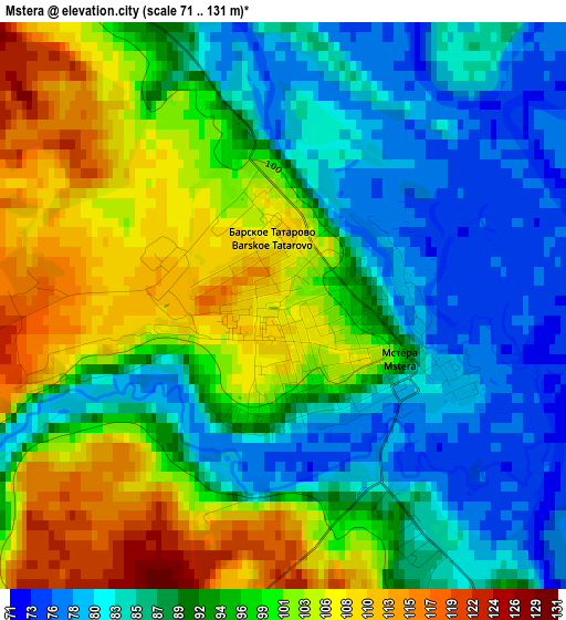
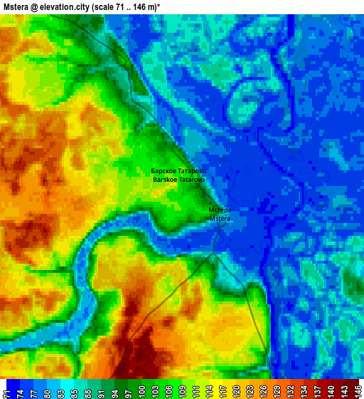
Below is the Elevation map of Mstera, which displays elevation range with different colors. Scale of the first map is from 71 to 131 m (233 to 430 ft) with average elevation of 93.7 meters (=307 ft) [note 1]
These maps also provides idea of topography and contour of this city, they are displayed at different zoom levels. More info about maps, scale and edge coordinates you can find below images.
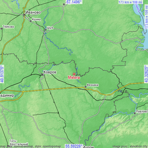
| \ | Map #1 | Map #2 | Topo.Map |
| Scale [m] | 71..131 m | 71..146 m | × |
| Scale [ft] | 233..430 ft | 233..479 ft | × |
| Average | 93.7 m = 307 ft | 97 m = 318 ft | × |
| Width | 5.41 km = 3.4 mi | 10.82 km = 6.7 mi | 173.2 km = 107.6 mi |
| Height | 5.41 km = 3.4 mi | 10.82 km = 6.7 mi | 173.1 km = 107.6 mi |
| ↑Max Latitude | 56.403215° | 56.427524° | 57.1496° |
| Latitude at center | 56.37889° | 56.37889° | 56.37889° |
| ↓Min Latitude | 56.35455° | 56.330194° | 55.59226° |
| ← Min Longitude | 41.876055° | 41.832109° | 40.51375° |
| Longitude center | 41.92° | 41.92° | 41.92° |
| →Max Longitude | 41.963945° | 42.007891° | 43.32625° |
Nearby cities:
Cities around Mstera sort by population:
• Kovrov elevation 128 m
37.1 km,  266°
266°
• Vyazniki 92 m
21.2 km,  136°
136°
• Yuzha 107 m
23.4 km,  14°
14°
• Melekhovo 97 m
40.2 km,  253°
253°
• Nikologory 121 m
26.8 km,  170°
170°
• Talitsy 102 m
30.3 km,  56°
56°
• Novovyazniki 133 m
25.4 km, 142°
• Stepantsevo 123 m
30.6 km,  205°
205°
• Luknovo 116 m
23.3 km,  161°
161°
• Oktyabr’skiy 132 m
19.3 km, 157°
• Frolishchi 107 m
45.3 km,  83°
83°
• Krasnyy Oktyabr’ 129 m
45.1 km,  227°
227°
Multilingual:
 En español:
Mstera elevación 105 m.
 En France:
Mstera élévation 105 m.


Sources and notes:
- [note 1] Map square and city borders are not equal. Map elevation data is calculated only from area inside that square.
- [src 1] Elevation data from geonames database provided with same terms of usage.
- [src 2] The elevation map of Mstera is generated using elevation data from NASA's 3 arcsec (90m) resolution SRTM data.
- [src 3] Base (background) map © OpenStreetMap contributors tiles are generated by Geofabrik and OpenTopoMap.
Copyright & License:
This Mstera Elevation Map is licensed under CC BY-SA. You may reuse any part from this page, if you give a proper credit by linking to this URL:
 More info on terms of use page.