Novaya Lyada elevation
Novaya Lyada (Tambov), Russia elevation is 153 meters and Novaya Lyada elevation in feet is 502 ft above sea level [src 1]. Novaya Lyada is a populated place (feature code) with elevation that is 46 meters (151 ft) smaller than average city elevation in Russia.
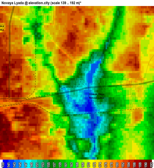
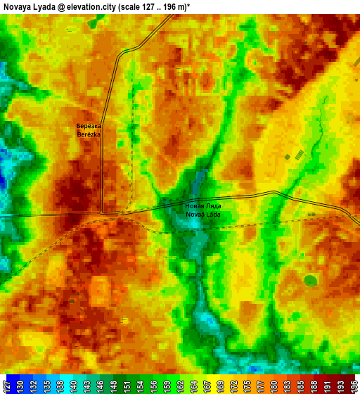
Below is the Elevation map of Novaya Lyada, which displays elevation range with different colors. Scale of the first map is from 139 to 192 m (456 to 630 ft) with average elevation of 169.6 meters (=556 ft) [note 1]
These maps also provides idea of topography and contour of this city, they are displayed at different zoom levels. More info about maps, scale and edge coordinates you can find below images.
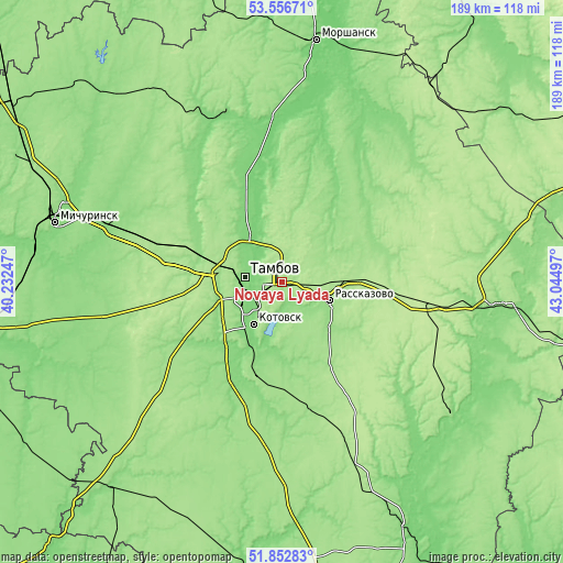
| \ | Map #1 | Map #2 | Topo.Map |
| Scale [m] | 139..192 m | 127..196 m | × |
| Scale [ft] | 456..630 ft | 417..643 ft | × |
| Average | 169.6 m = 556 ft | 170.5 m = 559 ft | × |
| Width | 5.92 km = 3.7 mi | 11.84 km = 7.4 mi | 189.5 km = 117.7 mi |
| Height | 5.92 km = 3.7 mi | 11.84 km = 7.4 mi | 189.4 km = 117.7 mi |
| ↑Max Latitude | 52.739704° | 52.766302° | 53.55671° |
| Latitude at center | 52.71309° | 52.71309° | 52.71309° |
| ↓Min Latitude | 52.68646° | 52.659813° | 51.85283° |
| ← Min Longitude | 41.594775° | 41.550829° | 40.23247° |
| Longitude center | 41.63872° | 41.63872° | 41.63872° |
| →Max Longitude | 41.682665° | 41.726611° | 43.04497° |
Nearby cities:
Cities around Novaya Lyada sort by population:
• Tambov elevation 128 m
13.3 km,  278°
278°
• Rasskazovo 154 m
17.7 km,  110°
110°
• Kotovsk 131 m
16.8 km,  213°
213°
• Znamenka 124 m
35.8 km,  203°
203°
• Pokrovo-Prigorodnoye 158 m
15.3 km,  257°
257°
• Selezni 140 m
28.7 km,  290°
290°
• Donskoye 118 m
12.8 km,  302°
302°
• Bokino 120 m
14.7 km,  235°
235°
• Goreloye 117 m
26.5 km,  340°
340°
• Platonovka 172 m
21.1 km,  90°
90°
• Komsomolets 176 m
24.5 km, 284°
• Satinka 165 m
37.2 km,  175°
175°
Multilingual:
 En español:
Novaya Lyada elevación 153 m.
 En France:
Novaya Lyada élévation 153 m.
 Auf Deutsch:
Novaya Lyada höhe über dem Meeresspiegel ist 153 m.

Sources and notes:
- [note 1] Map square and city borders are not equal. Map elevation data is calculated only from area inside that square.
- [src 1] Elevation data from geonames database provided with same terms of usage.
- [src 2] The elevation map of Novaya Lyada is generated using elevation data from NASA's 3 arcsec (90m) resolution SRTM data.
- [src 3] Base (background) map © OpenStreetMap contributors tiles are generated by Geofabrik and OpenTopoMap.
Copyright & License:
This Novaya Lyada Elevation Map is licensed under CC BY-SA. You may reuse any part from this page, if you give a proper credit by linking to this URL:
 More info on terms of use page.