Novoye Leushino elevation
Novoye Leushino (Ivanovo), Russia elevation is 130 meters and Novoye Leushino elevation in feet is 427 ft above sea level [src 1]. Novoye Leushino is a populated place (feature code) with elevation that is 69 meters (226 ft) smaller than average city elevation in Russia.
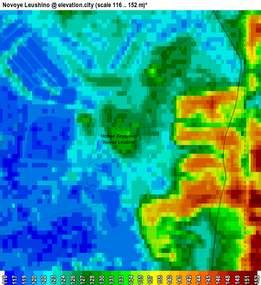
Below is the Elevation map of Novoye Leushino, which displays elevation range with different colors. Scale of the first map is from 116 to 152 m (381 to 499 ft) with average elevation of 125.9 meters (=413 ft) [note 1]
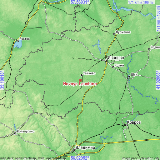
These maps also provides idea of topography and contour of this city, they are displayed at different zoom levels. More info about maps, scale and edge coordinates you can find below images.
| \ | Map #1 | Topo.Map |
| Scale [m] | 116..152 m | × |
| Scale [ft] | 381..499 ft | × |
| Average | 125.9 m = 413 ft | × |
| Width | 5.35 km = 3.3 mi | 171.2 km = 106.4 mi |
| Height | 5.35 km = 3.3 mi | 171.2 km = 106.4 mi |
| ↑Max Latitude | 56.83137° | 57.56931° |
| Latitude at center | 56.80732° | 56.80732° |
| ↓Min Latitude | 56.783254° | 56.02952° |
| ← Min Longitude | 40.470485° | 39.10818° |
| Longitude center | 40.51443° | 40.51443° |
| →Max Longitude | 40.558375° | 41.92068° |
Nearby cities:
Cities around Novoye Leushino sort by population:
• Ivanovo elevation 126 m
34.9 km,  52°
52°
• Teykovo 123 m
5.8 km,  13°
13°
• Kokhma 120 m
37.8 km,  67°
67°
• Komsomol’sk 152 m
26.1 km,  340°
340°
• Novo-Talitsy 124 m
30.3 km,  43°
43°
• Lezhnevo 108 m
23.3 km,  98°
98°
• Gavrilov Posad 123 m
36.6 km,  221°
221°
• Bogorodskoye 125 m
40.3 km, 48°
• Petrovskiy 117 m
21.9 km,  212°
212°
• Novyye Gorki 97 m
34.5 km,  105°
105°
• Nerl’ 123 m
17.8 km, 205°
• Markovo 150 m
23.5 km,  357°
357°
Multilingual:
 En español:
Novoye Leushino elevación 130 m.
 En France:
Novoye Leushino élévation 130 m.
 Auf Deutsch:
Novoye Leushino höhe über dem Meeresspiegel ist 130 m.
 На русском:
Нов.Леушино, Новое Леушино высота над уровнем моря 130 м
Sources and notes:
- [note 1] Map square and city borders are not equal. Map elevation data is calculated only from area inside that square.
- [src 1] Elevation data from geonames database provided with same terms of usage.
- [src 2] The elevation map of Novoye Leushino is generated using elevation data from NASA's 3 arcsec (90m) resolution SRTM data.
- [src 3] Base (background) map © OpenStreetMap contributors tiles are generated by Geofabrik and OpenTopoMap.
Copyright & License:
This Novoye Leushino Elevation Map is licensed under CC BY-SA. You may reuse any part from this page, if you give a proper credit by linking to this URL:
 More info on terms of use page.