Odoyev elevation
Odoyev (Tula), Russia elevation is 219 meters and Odoyev elevation in feet is 719 ft above sea level [src 1]. Odoyev is a populated place (feature code) with elevation that is 20 meters (66 ft) bigger than average city elevation in Russia.
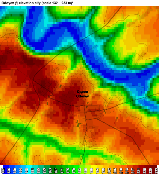
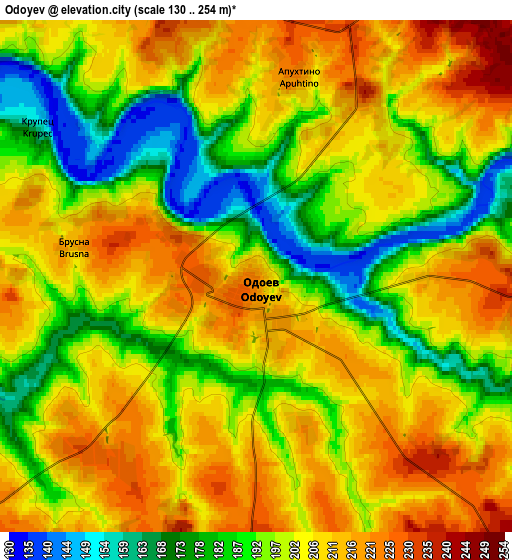
Below is the Elevation map of Odoyev, which displays elevation range with different colors. Scale of the first map is from 132 to 233 m (433 to 764 ft) with average elevation of 190.2 meters (=624 ft) [note 1]
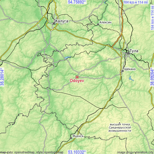
These maps also provides idea of topography and contour of this city, they are displayed at different zoom levels. More info about maps, scale and edge coordinates you can find below images.
| \ | Map #1 | Map #2 | Topo.Map |
| Scale [m] | 132..233 m | 130..254 m | × |
| Scale [ft] | 433..764 ft | 427..833 ft | × |
| Average | 190.2 m = 624 ft | 200 m = 656 ft | × |
| Width | 5.75 km = 3.6 mi | 11.51 km = 7.2 mi | 184.1 km = 114.4 mi |
| Height | 5.75 km = 3.6 mi | 11.51 km = 7.2 mi | 184.1 km = 114.4 mi |
| ↑Max Latitude | 53.96519° | 53.991034° | 54.75892° |
| Latitude at center | 53.93933° | 53.93933° | 53.93933° |
| ↓Min Latitude | 53.913454° | 53.887562° | 53.10332° |
| ← Min Longitude | 36.642445° | 36.598499° | 35.28014° |
| Longitude center | 36.68639° | 36.68639° | 36.68639° |
| →Max Longitude | 36.730335° | 36.774281° | 38.09264° |
Nearby cities:
Cities around Odoyev sort by population:
• Suvorov elevation 191 m
23.8 km,  328°
328°
• Plavsk 180 m
47.3 km,  122°
122°
• Belëv 176 m
39 km,  248°
248°
• Sosenskiy 219 m
49.2 km,  285°
285°
• Dubna 177 m
29.9 km,  36°
36°
• Ageyevo 173 m
28.2 km, 329°
• Arsen’yevo 231 m
22.3 km,  183°
183°
• Cherepet’ 147 m
28.2 km,  314°
314°
• Slavniy 220 m
45.9 km,  197°
197°
• Krapivna 177 m
30.8 km,  89°
89°
• Khanino 196 m
30.5 km,  352°
352°
• Chekalin 191 m
33.7 km,  301°
301°
Multilingual:
 En español:
Odoyev elevación 219 m.
 En France:
Odoyev élévation 219 m.


Sources and notes:
- [note 1] Map square and city borders are not equal. Map elevation data is calculated only from area inside that square.
- [src 1] Elevation data from geonames database provided with same terms of usage.
- [src 2] The elevation map of Odoyev is generated using elevation data from NASA's 3 arcsec (90m) resolution SRTM data.
- [src 3] Base (background) map © OpenStreetMap contributors tiles are generated by Geofabrik and OpenTopoMap.
Copyright & License:
This Odoyev Elevation Map is licensed under CC BY-SA. You may reuse any part from this page, if you give a proper credit by linking to this URL:
 More info on terms of use page.