Omutninsk elevation
Omutninsk (Kirov), Russia elevation is 184 meters and Omutninsk elevation in feet is 604 ft above sea level [src 1]. Omutninsk is a populated place (feature code) with elevation that is 15 meters (49 ft) smaller than average city elevation in Russia.
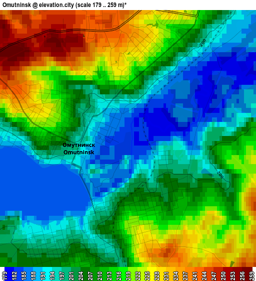
Below is the Elevation map of Omutninsk, which displays elevation range with different colors. Scale of the first map is from 179 to 259 m (587 to 850 ft) with average elevation of 208 meters (=682 ft) [note 1]
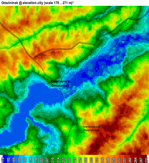
These maps also provides idea of topography and contour of this city, they are displayed at different zoom levels. More info about maps, scale and edge coordinates you can find below images.
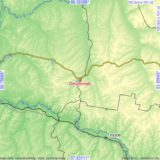
| \ | Map #1 | Map #2 | Topo.Map |
| Scale [m] | 179..259 m | 178..271 m | × |
| Scale [ft] | 587..850 ft | 584..889 ft | × |
| Average | 208 m = 682 ft | 219.7 m = 721 ft | × |
| Width | 5.08 km = 3.2 mi | 10.16 km = 6.3 mi | 162.6 km = 101 mi |
| Height | 5.08 km = 3.2 mi | 10.16 km = 6.3 mi | 162.6 km = 101 mi |
| ↑Max Latitude | 58.692853° | 58.71568° | 59.39358° |
| Latitude at center | 58.67001° | 58.67001° | 58.67001° |
| ↓Min Latitude | 58.647152° | 58.62428° | 57.93111° |
| ← Min Longitude | 52.149255° | 52.105309° | 50.78695° |
| Longitude center | 52.1932° | 52.1932° | 52.1932° |
| →Max Longitude | 52.237145° | 52.281091° | 53.59945° |
Nearby cities:
Cities around Omutninsk sort by population:
• Glazov elevation 151 m
64.9 km,  155°
155°
• Zuyevka 136 m
68.2 km,  244°
244°
• Vostochnyy 229 m
13.5 km,  12°
12°
• Yar 147 m
47.4 km,  186°
186°
• Peskovka 197 m
42.8 km, 13°
• Falënki 157 m
48.9 km,  225°
225°
• Kostino 197 m
67.5 km,  66°
66°
• Kosino 126 m
60.3 km, 241°
• Pudem 146 m
40.6 km,  182°
182°
• Lesnyye Polyany 218 m
39.2 km,  19°
19°
• Chërnaya Kholunitsa 190 m
34.1 km,  306°
306°
• Belorechensk 197 m
12.8 km,  26°
26°
Multilingual:
 En español:
Omutninsk elevación 184 m.
 En France:
Omoutninsk élévation 184 m.
 Auf Deutsch:
Omutninsk höhe über dem Meeresspiegel ist 184 m.

Sources and notes:
- [note 1] Map square and city borders are not equal. Map elevation data is calculated only from area inside that square.
- [src 1] Elevation data from geonames database provided with same terms of usage.
- [src 2] The elevation map of Omutninsk is generated using elevation data from NASA's 3 arcsec (90m) resolution SRTM data.
- [src 3] Base (background) map © OpenStreetMap contributors tiles are generated by Geofabrik and OpenTopoMap.
Copyright & License:
This Omutninsk Elevation Map is licensed under CC BY-SA. You may reuse any part from this page, if you give a proper credit by linking to this URL:
 More info on terms of use page.