Onega elevation
Onega (Arkhangelskaya), Russia elevation is 32 meters and Onega elevation in feet is 105 ft above sea level [src 1]. Onega is a populated place (feature code) with elevation that is 167 meters (548 ft) smaller than average city elevation in Russia.
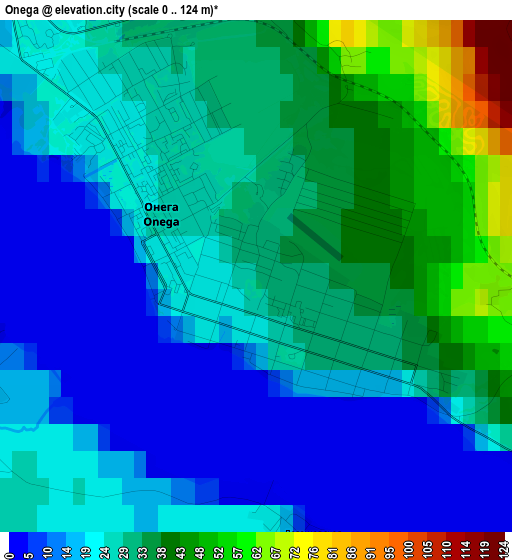
Below is the Elevation map of Onega, which displays elevation range with different colors. Scale of the first map is from 0 to 124 m (0 to 407 ft) with average elevation of 25.3 meters (=83 ft) [note 1]
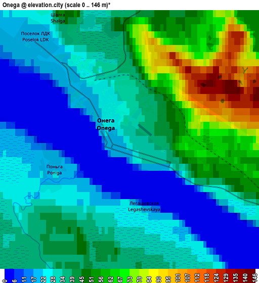
These maps also provides idea of topography and contour of this city, they are displayed at different zoom levels. More info about maps, scale and edge coordinates you can find below images.
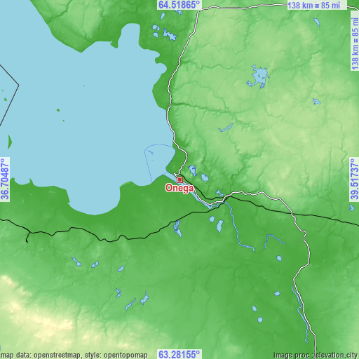
| \ | Map #1 | Map #2 | Topo.Map |
| Scale [m] | 0..124 m | 0..146 m | × |
| Scale [ft] | 0..407 ft | 0..479 ft | × |
| Average | 25.3 m = 83 ft | 37.4 m = 123 ft | × |
| Width | 4.3 km = 2.7 mi | 8.6 km = 5.3 mi | 137.6 km = 85.5 mi |
| Height | 4.3 km = 2.7 mi | 8.6 km = 5.3 mi | 137.5 km = 85.4 mi |
| ↑Max Latitude | 63.926242° | 63.94555° | 64.51865° |
| Latitude at center | 63.90692° | 63.90692° | 63.90692° |
| ↓Min Latitude | 63.887585° | 63.868236° | 63.28155° |
| ← Min Longitude | 38.067175° | 38.023229° | 36.70487° |
| Longitude center | 38.11112° | 38.11112° | 38.11112° |
| →Max Longitude | 38.155065° | 38.199011° | 39.51737° |
Nearby cities:
Cities around Onega sort by population:
• Arkhangel’sk elevation 8 m
137.1 km,  59°
59°
• Severodvinsk 8 m
110.6 km,  48°
48°
• Novodvinsk 24 m
142.6 km,  66°
66°
• Yagry 8 m
112.1 km, 47°
• Isakogorka 15 m
136.9 km, 64°
• Mirnyy 114 m
168.8 km,  138°
138°
• Uyemskiy 7 m
146.9 km, 64°
• Katunino 20 m
133.2 km, 66°
• Kodino 40 m
78.1 km,  105°
105°
• Samoded 59 m
122.6 km, 105°
• Yemtsa 107 m
144 km,  130°
130°
• Vas’kovo 45 m
127.1 km, 63°
Multilingual:
 En español:
Onega elevación 32 m.
 En France:
Onega élévation 32 m.


Sources and notes:
- [note 1] Map square and city borders are not equal. Map elevation data is calculated only from area inside that square.
- [src 1] Elevation data from geonames database provided with same terms of usage.
- [src 2] The elevation map of Onega is generated using GMTED2010 database with 7.5 arcsec (225m) resolution.
- [src 3] Base (background) map © OpenStreetMap contributors tiles are generated by Geofabrik and OpenTopoMap.
Copyright & License:
This Onega Elevation Map is licensed under CC BY-SA. You may reuse any part from this page, if you give a proper credit by linking to this URL:
 More info on terms of use page.