Petrovo-Dal’neye elevation
Petrovo-Dal’neye (Moscow Oblast), Russia elevation is 141 meters and Petrovo-Dal’neye elevation in feet is 463 ft above sea level [src 1]. Petrovo-Dal’neye is a populated place (feature code) with elevation that is 58 meters (190 ft) smaller than average city elevation in Russia.
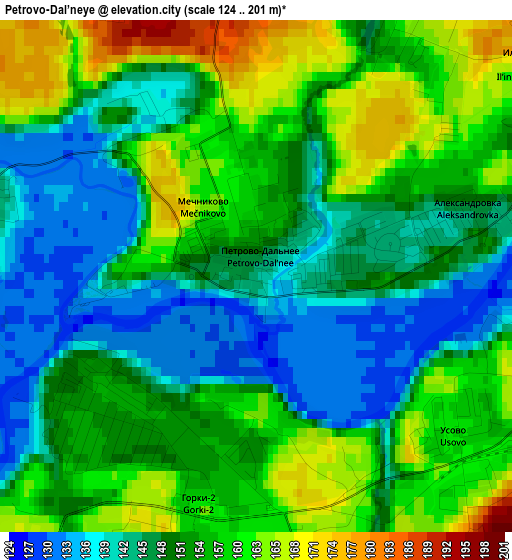
Below is the Elevation map of Petrovo-Dal’neye, which displays elevation range with different colors. Scale of the first map is from 124 to 201 m (407 to 659 ft) with average elevation of 151.6 meters (=497 ft) [note 1]
These maps also provides idea of topography and contour of this city, they are displayed at different zoom levels. More info about maps, scale and edge coordinates you can find below images.
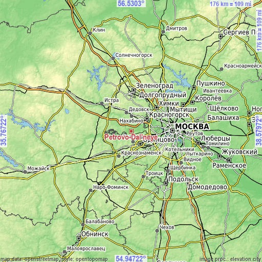
| \ | Map #1 | Topo.Map |
| Scale [m] | 124..201 m | × |
| Scale [ft] | 407..659 ft | × |
| Average | 151.6 m = 497 ft | × |
| Width | 5.5 km = 3.4 mi | 176 km = 109.4 mi |
| Height | 5.5 km = 3.4 mi | 176 km = 109.4 mi |
| ↑Max Latitude | 55.771517° | 56.5303° |
| Latitude at center | 55.74679° | 55.74679° |
| ↓Min Latitude | 55.722047° | 54.94722° |
| ← Min Longitude | 37.129525° | 35.76722° |
| Longitude center | 37.17347° | 37.17347° |
| →Max Longitude | 37.217415° | 38.57972° |
Nearby cities:
Cities around Petrovo-Dal’neye sort by population:
• Odintsovo elevation 199 m
10.1 km,  139°
139°
• Nakhabino 183 m
11.3 km,  1°
1°
• Vniissok 188 m
10.3 km,  166°
166°
• Nikolina Gora 175 m
8.2 km,  260°
260°
• Pavlovskaya Sloboda 161 m
9.5 km,  323°
323°
• Opalikha 188 m
10.1 km,  29°
29°
• Nemchinovka 178 m
12 km,  102°
102°
• Barvikha 146 m
6.6 km,  94°
94°
• Arkhangel’skoye 159 m
9.1 km,  59°
59°
• Gorki Vtoryye 159 m
2.4 km,  194°
194°
• Zhavoronki 195 m
11.7 km,  202°
202°
• Nazar'yevo 185 m
11.6 km,  225°
225°
Multilingual:
 En español:
Petrovo-Dal’neye elevación 141 m.
 En France:
Petrovo-Dal’neye élévation 141 m.
 Auf Deutsch:
Petrovo-Dal’neye höhe über dem Meeresspiegel ist 141 m.

Sources and notes:
- [note 1] Map square and city borders are not equal. Map elevation data is calculated only from area inside that square.
- [src 1] Elevation data from geonames database provided with same terms of usage.
- [src 2] The elevation map of Petrovo-Dal’neye is generated using elevation data from NASA's 3 arcsec (90m) resolution SRTM data.
- [src 3] Base (background) map © OpenStreetMap contributors tiles are generated by Geofabrik and OpenTopoMap.
Copyright & License:
This Petrovo-Dal’neye Elevation Map is licensed under CC BY-SA. You may reuse any part from this page, if you give a proper credit by linking to this URL:
 More info on terms of use page.