Pindushi elevation
Pindushi (Karelia), Russia elevation is 56 meters and Pindushi elevation in feet is 184 ft above sea level [src 1]. Pindushi is a populated place (feature code) with elevation that is 143 meters (469 ft) smaller than average city elevation in Russia.
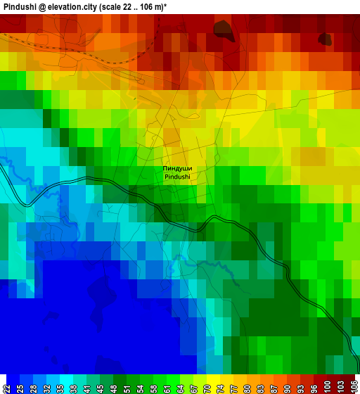
Below is the Elevation map of Pindushi, which displays elevation range with different colors. Scale of the first map is from 22 to 106 m (72 to 348 ft) with average elevation of 56.9 meters (=187 ft) [note 1]
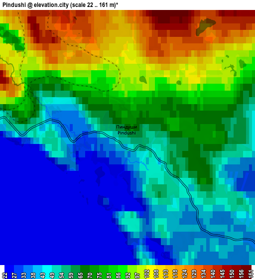
These maps also provides idea of topography and contour of this city, they are displayed at different zoom levels. More info about maps, scale and edge coordinates you can find below images.
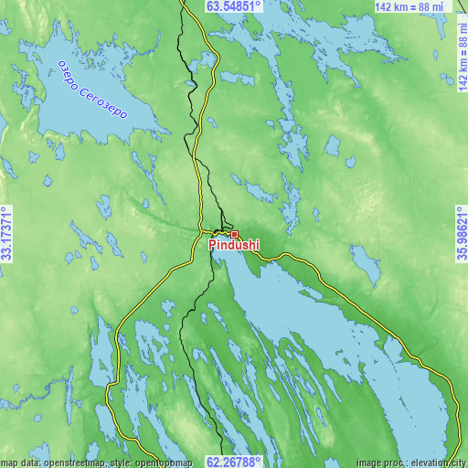
| \ | Map #1 | Map #2 | Topo.Map |
| Scale [m] | 22..106 m | 22..161 m | × |
| Scale [ft] | 72..348 ft | 72..528 ft | × |
| Average | 56.9 m = 187 ft | 65.6 m = 215 ft | × |
| Width | 4.45 km = 2.8 mi | 8.9 km = 5.5 mi | 142.4 km = 88.5 mi |
| Height | 4.45 km = 2.8 mi | 8.9 km = 5.5 mi | 142.4 km = 88.5 mi |
| ↑Max Latitude | 62.935192° | 62.95518° | 63.54851° |
| Latitude at center | 62.91519° | 62.91519° | 62.91519° |
| ↓Min Latitude | 62.895174° | 62.875145° | 62.26788° |
| ← Min Longitude | 34.536015° | 34.492069° | 33.17371° |
| Longitude center | 34.57996° | 34.57996° | 34.57996° |
| →Max Longitude | 34.623905° | 34.667851° | 35.98621° |
Nearby cities:
Cities around Pindushi sort by population:
• Petrozavodsk elevation 73 m
126.2 km,  185°
185°
• Kondopoga 67 m
80.6 km, 191°
• Segezha 88 m
92.8 km,  352°
352°
• Medvezh’yegorsk 43 m
6.2 km,  271°
271°
• Nadvoitsy 79 m
106.6 km, 352°
• Porosozero 202 m
96.6 km,  256°
256°
• Shuya 75 m
108.5 km, 189°
• Povenets 40 m
14.5 km,  120°
120°
• Sukkozero 227 m
116.2 km,  284°
284°
• Shun’ga 23 m
39.5 km,  151°
151°
• Girvas 88 m
66.6 km,  223°
223°
• Yanishpole 23 m
90.8 km, 190°
Multilingual:
 En español:
Pindushi elevación 56 m.
 En France:
Pindushi élévation 56 m.


Sources and notes:
- [note 1] Map square and city borders are not equal. Map elevation data is calculated only from area inside that square.
- [src 1] Elevation data from geonames database provided with same terms of usage.
- [src 2] The elevation map of Pindushi is generated using GMTED2010 database with 7.5 arcsec (225m) resolution.
- [src 3] Base (background) map © OpenStreetMap contributors tiles are generated by Geofabrik and OpenTopoMap.
Copyright & License:
This Pindushi Elevation Map is licensed under CC BY-SA. You may reuse any part from this page, if you give a proper credit by linking to this URL:
 More info on terms of use page.