Pontonnyy elevation
Pontonnyy (St.-Petersburg), Russia elevation is 19 meters and Pontonnyy elevation in feet is 62 ft above sea level [src 1]. Pontonnyy is a populated place (feature code) with elevation that is 180 meters (591 ft) smaller than average city elevation in Russia.
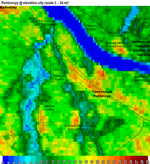
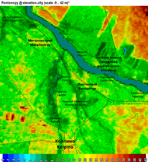
Below is the Elevation map of Pontonnyy, which displays elevation range with different colors. Scale of the first map is from 3 to 24 m (10 to 79 ft) with average elevation of 13.1 meters (=43 ft) [note 1]
These maps also provides idea of topography and contour of this city, they are displayed at different zoom levels. More info about maps, scale and edge coordinates you can find below images.
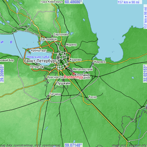
| \ | Map #1 | Map #2 | Topo.Map |
| Scale [m] | 3..24 m | -9..42 m | × |
| Scale [ft] | 10..79 ft | -30..138 ft | × |
| Average | 13.1 m = 43 ft | 16.4 m = 54 ft | × |
| Width | 4.92 km = 3.1 mi | 9.84 km = 6.1 mi | 157.4 km = 97.8 mi |
| Height | 4.92 km = 3.1 mi | 9.84 km = 6.1 mi | 157.4 km = 97.8 mi |
| ↑Max Latitude | 59.808777° | 59.830869° | 60.48686° |
| Latitude at center | 59.78667° | 59.78667° | 59.78667° |
| ↓Min Latitude | 59.764548° | 59.742412° | 59.07148° |
| ← Min Longitude | 30.571335° | 30.527389° | 29.20903° |
| Longitude center | 30.61528° | 30.61528° | 30.61528° |
| →Max Longitude | 30.659225° | 30.703171° | 32.02153° |
Nearby cities:
Cities around Pontonnyy sort by population:
• Kolpino elevation 19 m
4.3 km,  200°
200°
• Rybatskoye 19 m
8.8 km,  311°
311°
• Obukhovo 14 m
11.2 km,  304°
304°
• Metallostroy 16 m
4.1 km,  292°
292°
• Otradnoye 20 m
11.4 km,  95°
95°
• Shushary 24 m
13.3 km,  280°
280°
• Imeni Sverdlova 16 m
3 km,  69°
69°
• Krasnyy Bor 48 m
12 km,  165°
165°
• Tyarlevo 26 m
12.9 km,  227°
227°
• Sapërnyy 16 m
2.8 km,  114°
114°
• Ust’-Izhora 15 m
3.4 km,  325°
325°
• Petro-Slavyanka 17 m
6.3 km, 285°
Multilingual:
 En español:
Pontonnyy elevación 19 m.
 En France:
Pontonnyy élévation 19 m.
 Auf Deutsch:
Pontonnyy höhe über dem Meeresspiegel ist 19 m.

Sources and notes:
- [note 1] Map square and city borders are not equal. Map elevation data is calculated only from area inside that square.
- [src 1] Elevation data from geonames database provided with same terms of usage.
- [src 2] The elevation map of Pontonnyy is generated using elevation data from NASA's 3 arcsec (90m) resolution SRTM data.
- [src 3] Base (background) map © OpenStreetMap contributors tiles are generated by Geofabrik and OpenTopoMap.
Copyright & License:
This Pontonnyy Elevation Map is licensed under CC BY-SA. You may reuse any part from this page, if you give a proper credit by linking to this URL:
 More info on terms of use page.