Pytalovo elevation
Pytalovo (Pskov Oblast), Russia elevation is 80 meters and Pytalovo elevation in feet is 262 ft above sea level [src 1]. Pytalovo is a populated place (feature code) with elevation that is 119 meters (390 ft) smaller than average city elevation in Russia.
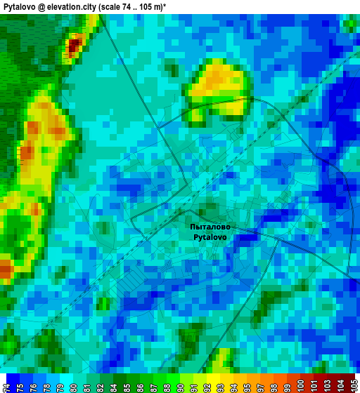
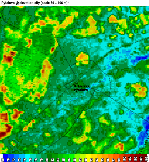
Below is the Elevation map of Pytalovo, which displays elevation range with different colors. Scale of the first map is from 74 to 105 m (243 to 344 ft) with average elevation of 80.5 meters (=264 ft) [note 1]
These maps also provides idea of topography and contour of this city, they are displayed at different zoom levels. More info about maps, scale and edge coordinates you can find below images.
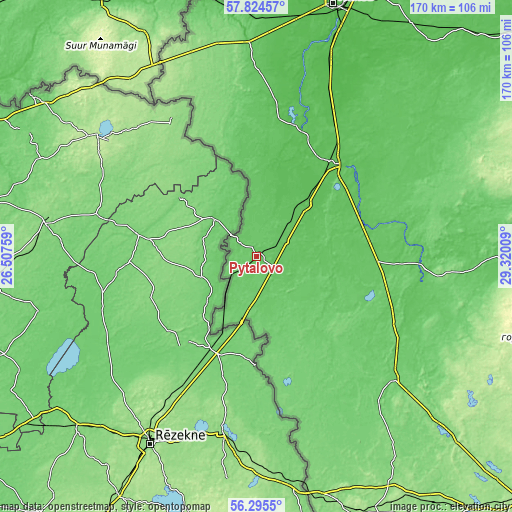
| \ | Map #1 | Map #2 | Topo.Map |
| Scale [m] | 74..105 m | 69..106 m | × |
| Scale [ft] | 243..344 ft | 226..348 ft | × |
| Average | 80.5 m = 264 ft | 82.1 m = 269 ft | × |
| Width | 5.31 km = 3.3 mi | 10.63 km = 6.6 mi | 170 km = 105.6 mi |
| Height | 5.31 km = 3.3 mi | 10.63 km = 6.6 mi | 170 km = 105.6 mi |
| ↑Max Latitude | 57.091793° | 57.115661° | 57.82457° |
| Latitude at center | 57.06791° | 57.06791° | 57.06791° |
| ↓Min Latitude | 57.044012° | 57.020098° | 56.2955° |
| ← Min Longitude | 27.869895° | 27.825949° | 26.50759° |
| Longitude center | 27.91384° | 27.91384° | 27.91384° |
| →Max Longitude | 27.957785° | 28.001731° | 29.32009° |
Nearby cities:
Cities around Pytalovo sort by population:
• Ostrov elevation 70 m
40.5 km,  40°
40°
• Krasnogorodsk 89 m
34.1 km,  139°
139°
• Palkino 67 m
52.9 km,  6°
6°
• Makushino 107 m
54.2 km, 141°
• Varygino 88 m
50.7 km,  131°
131°
• Matyushkino 89 m
48.7 km,  117°
117°
• Pokrovskoye 101 m
46.9 km,  153°
153°
• Vel’ye 88 m
41.7 km,  105°
105°
• Lukino 103 m
40.6 km, 124°
• Il’inskoye 104 m
40.3 km, 113°
• Kresty 102 m
34.2 km,  161°
161°
• Blyasino 83 m
27.4 km, 119°
Multilingual:
 En español:
Pytalovo elevación 80 m.
 En France:
Pytalovo élévation 80 m.


Sources and notes:
- [note 1] Map square and city borders are not equal. Map elevation data is calculated only from area inside that square.
- [src 1] Elevation data from geonames database provided with same terms of usage.
- [src 2] The elevation map of Pytalovo is generated using elevation data from NASA's 3 arcsec (90m) resolution SRTM data.
- [src 3] Base (background) map © OpenStreetMap contributors tiles are generated by Geofabrik and OpenTopoMap.
Copyright & License:
This Pytalovo Elevation Map is licensed under CC BY-SA. You may reuse any part from this page, if you give a proper credit by linking to this URL:
 More info on terms of use page.