Roshal’ elevation
Roshal’ (Moscow Oblast), Russia elevation is 117 meters and Roshal’ elevation in feet is 384 ft above sea level [src 1]. Roshal’ is a populated place (feature code) with elevation that is 82 meters (269 ft) smaller than average city elevation in Russia.
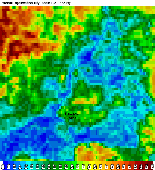
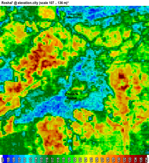
Below is the Elevation map of Roshal’, which displays elevation range with different colors. Scale of the first map is from 108 to 135 m (354 to 443 ft) with average elevation of 117.6 meters (=386 ft) [note 1]
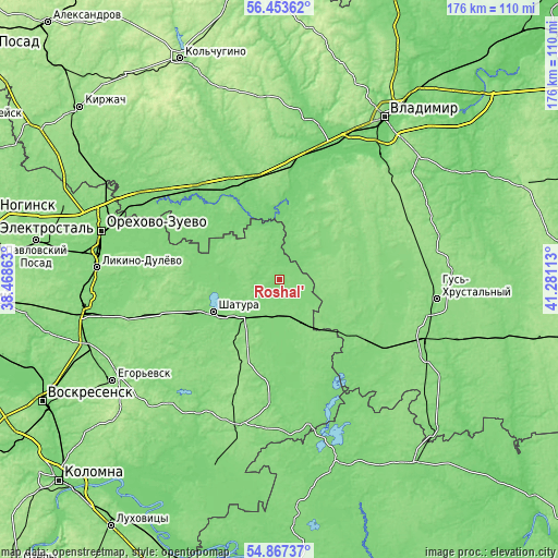
These maps also provides idea of topography and contour of this city, they are displayed at different zoom levels. More info about maps, scale and edge coordinates you can find below images.
| \ | Map #1 | Map #2 | Topo.Map |
| Scale [m] | 108..135 m | 107..136 m | × |
| Scale [ft] | 354..443 ft | 351..446 ft | × |
| Average | 117.6 m = 386 ft | 119.9 m = 393 ft | × |
| Width | 5.51 km = 3.4 mi | 11.02 km = 6.8 mi | 176.4 km = 109.6 mi |
| Height | 5.51 km = 3.4 mi | 11.02 km = 6.8 mi | 176.4 km = 109.6 mi |
| ↑Max Latitude | 55.693306° | 55.718067° | 56.45362° |
| Latitude at center | 55.66853° | 55.66853° | 55.66853° |
| ↓Min Latitude | 55.643738° | 55.61893° | 54.86737° |
| ← Min Longitude | 39.830935° | 39.786989° | 38.46863° |
| Longitude center | 39.87488° | 39.87488° | 39.87488° |
| →Max Longitude | 39.918825° | 39.962771° | 41.28113° |
Nearby cities:
Cities around Roshal’ sort by population:
• Shatura elevation 124 m
23.8 km,  243°
243°
• Sobinka 105 m
36.3 km,  13°
13°
• Kosterevo 120 m
33.3 km,  330°
330°
• Urshel’skiy 139 m
21.5 km,  87°
87°
• Misheronskiy 130 m
10.2 km,  303°
303°
• Shaturtorf 137 m
30.6 km,  248°
248°
• Cherusti 126 m
15.7 km,  147°
147°
• Kerva 126 m
19.8 km, 251°
• Baksheyevo 112 m
4.5 km,  1°
1°
• Tugolesskiy Bor 120 m
13.5 km,  193°
193°
• Mezinovskiy 127 m
35.5 km,  120°
120°
• Savinskaya 124 m
34 km,  167°
167°
Multilingual:
 En español:
Roshal’ elevación 117 m.
 En France:
Roshal’ élévation 117 m.


Sources and notes:
- [note 1] Map square and city borders are not equal. Map elevation data is calculated only from area inside that square.
- [src 1] Elevation data from geonames database provided with same terms of usage.
- [src 2] The elevation map of Roshal’ is generated using elevation data from NASA's 3 arcsec (90m) resolution SRTM data.
- [src 3] Base (background) map © OpenStreetMap contributors tiles are generated by Geofabrik and OpenTopoMap.
Copyright & License:
This Roshal’ Elevation Map is licensed under CC BY-SA. You may reuse any part from this page, if you give a proper credit by linking to this URL:
 More info on terms of use page.